Map of Ponder town
Ponder is a town in Denton County, Texas, United States. The population was 2,442 in 2020. Ponder town overview: Name: Ponder town LSAD Code: 43 LSAD Description: town (suffix) State: Texas County: Denton County Elevation: 732 ft (223 m) Total Area: 3.39 sq mi (8.77 km²) Land Area: 3.38 sq mi (8.76 km²) Water Area: 0.00 sq mi (0.01 km²) Total Population: 2,442 ZIP code: 76259 ... Read more
Map of Ponder town
Map of Point city
Point is a city in Rains County, Texas, United States. The population was 820 at the 2010 census. Point city overview: Name: Point city LSAD Code: 25 LSAD Description: city (suffix) State: Texas County: Rains County Elevation: 528 ft (161 m) Total Area: 2.78 sq mi (7.21 km²) Land Area: 2.76 sq mi (7.14 km²) Water Area: 0.03 sq mi (0.07 km²) Total Population: 820 Population ... Read more
Map of Point city
Map of Point Venture village
Point Venture is a village in western Travis County, Texas. The population was 800 as of the 2010 census. Located on the north bank of Lake Travis, Point Venture was a second home and family vacation destination, since the early 1970s. It has matured into a community of full-time residents with over 150 children attending ... Read more
Map of Point Venture village
Map of Point Comfort city
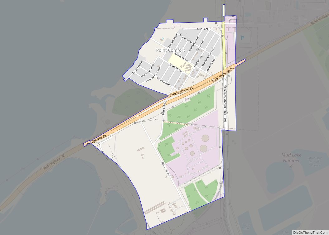
Point Comfort is a city in Calhoun County, Texas, United States. It is a part of the Victoria, Texas Metropolitan Statistical Area. The population was 737 at the 2010 census. Point Comfort city overview: Name: Point Comfort city LSAD Code: 25 LSAD Description: city (suffix) State: Texas County: Calhoun County Elevation: 16 ft (5 m) Total Area: ... Read more
Map of Point Comfort city
Map of Poteet city
Poteet is a city in Atascosa County, Texas, United States. The population was 3,260 as of the 2010 census. It is part of the San Antonio Metropolitan Statistical Area. It was named for its first postmaster, Francis Marion Poteet. It is best known as the birthplace of country music legend, George Strait. Poteet is known ... Read more
Map of Poteet city
Map of Post city
Post is a city in and the county seat of Garza County, Texas, United States. Its population was 5,376 at the 2010 census. Post city overview: Name: Post city LSAD Code: 25 LSAD Description: city (suffix) State: Texas County: Garza County Elevation: 2,605 ft (794 m) Total Area: 3.77 sq mi (9.77 km²) Land Area: 3.75 sq mi (9.70 km²) Water Area: 0.03 sq mi ... Read more
Map of Post city
Map of Post Oak Bend City town
Post Oak Bend City is a town in Kaufman County, Texas, United States. The population was 683 in 2020. Post Oak Bend City town overview: Name: Post Oak Bend City town LSAD Code: 43 LSAD Description: town (suffix) State: Texas County: Kaufman County Elevation: 440 ft (134 m) Total Area: 2.05 sq mi (5.31 km²) Land Area: 2.04 sq mi (5.30 km²) Water ... Read more
Map of Post Oak Bend City town
Map of Portland city, Texas
Portland is a city in Nueces and San Patricio Counties in the U.S. state of Texas. Its population was 20,383 as of the 2020 United States census. Portland is a suburb of Corpus Christi, located on the north shore of Nueces and Corpus Christi Bays. Portland city overview: Name: Portland city LSAD Code: 25 LSAD ... Read more
Map of Portland city, Texas
Map of Porter Heights CDP
Porter Heights is a census-designated place (CDP) in Montgomery County, Texas, United States. The population was 1,903 at the 2020 census. Porter Heights CDP overview: Name: Porter Heights CDP LSAD Code: 57 LSAD Description: CDP (suffix) State: Texas County: Montgomery County Elevation: 125 ft (38 m) Total Area: 3.2 sq mi (8.2 km²) Land Area: 3.2 sq mi (8.2 km²) Water Area: 0.0 sq mi ... Read more
Map of Porter Heights CDP
Map of Port O’Connor CDP
Port O’Connor is an unincorporated community and census-designated place (CDP) in Calhoun County, Texas, United States, near the Gulf coastline between Galveston and Corpus Christi. The CDP had a population of 1,253 at the 2010 census. It is part of the Victoria, Texas metropolitan statistical area. Port O’Connor CDP overview: Name: Port O’Connor CDP LSAD ... Read more
Map of Port O’Connor CDP
Map of Port Neches city
Port Neches is a city in Jefferson County, Texas, United States. The population was 13,692 at the 2020 census, up from 13,040 at the 2010 census. It is part of the Beaumont–Port Arthur metropolitan area. Port Neches city overview: Name: Port Neches city LSAD Code: 25 LSAD Description: city (suffix) State: Texas County: Jefferson County ... Read more
Map of Port Neches city
Map of Port Mansfield CDP
Port Mansfield is a census-designated place (CDP) in Willacy County, Texas, United States. The population was 226 at the 2010 census. Port Mansfield CDP overview: Name: Port Mansfield CDP LSAD Code: 57 LSAD Description: CDP (suffix) State: Texas County: Willacy County Elevation: 3 ft (1 m) Total Area: 5.7 sq mi (14.8 km²) Land Area: 5.2 sq mi (13.5 km²) Water Area: 0.5 sq mi ... Read more
Map of Port Mansfield CDP