Map of Santa Anna CDP
Santa Anna is a census-designated place (CDP) in Starr County, Texas, United States. This was a new CDP for the 2010 census with a population of 13. Santa Anna CDP overview: Name: Santa Anna CDP LSAD Code: 57 LSAD Description: CDP (suffix) State: Texas County: Starr County Total Area: 0.7 sq mi (2 km²) Land Area: 0.7 sq mi (2 km²) ... Read more
Map of Santa Anna CDP
Map of Sansom Park city
Sansom Park is a city in Tarrant County, Texas, United States. Its population was 4,686 at the 2010 census. Sansom Park city overview: Name: Sansom Park city LSAD Code: 25 LSAD Description: city (suffix) State: Texas County: Tarrant County Elevation: 751 ft (229 m) Total Area: 1.24 sq mi (3.21 km²) Land Area: 1.24 sq mi (3.21 km²) Water Area: 0.00 sq mi (0.00 km²) Total ... Read more
Map of Sansom Park city
Map of Sanger city, Texas
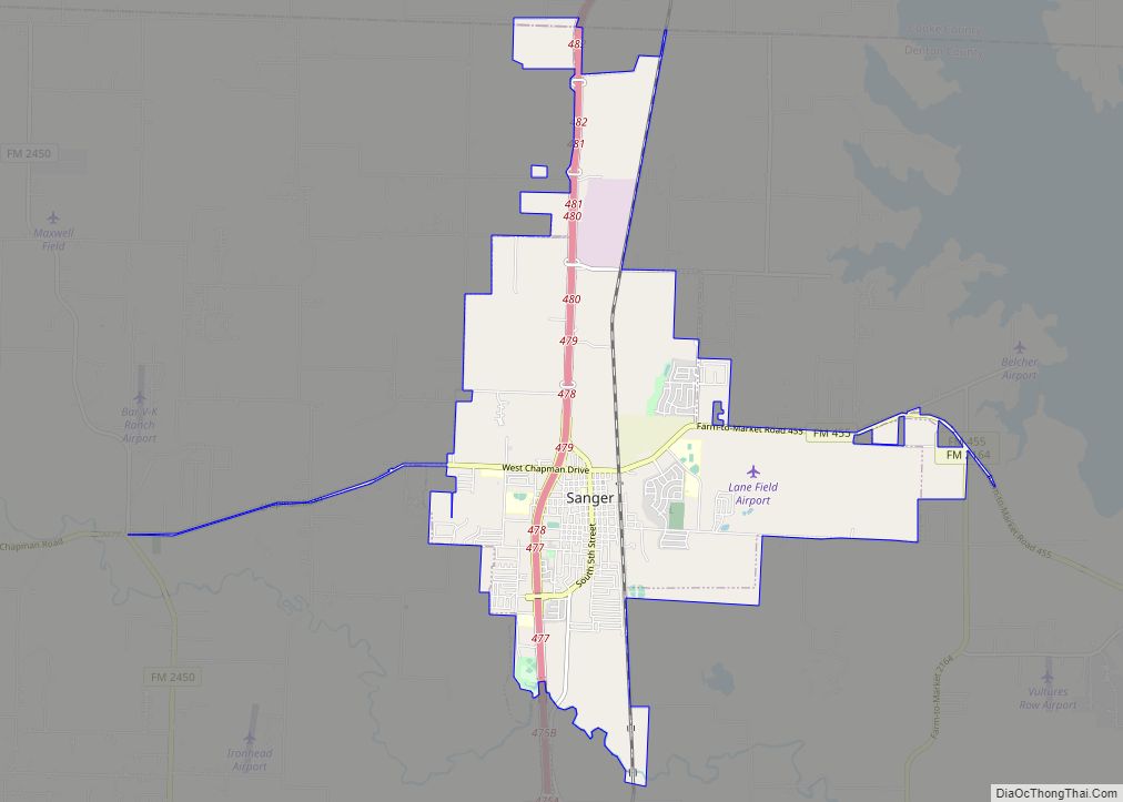
Sanger is a city in Denton County, Texas, United States. The population was 6,916 at the 2010 census, and 8,839 at the 2020 census. Sanger city overview: Name: Sanger city LSAD Code: 25 LSAD Description: city (suffix) State: Texas County: Denton County Elevation: 673 ft (205 m) Total Area: 11.81 sq mi (30.59 km²) Land Area: 11.76 sq mi (30.46 km²) Water Area: ... Read more
Map of Sanger city, Texas
Map of Sanford town, Texas
Sanford is a town in Hutchinson County, Texas, United States. The population was 164 at the 2010 census, down from 203 at the 2000 census. On December 28, 1974, Hee Haw Season 6, Episode 16, Red Steagall saluted his hometown of Sanford, population 181. Sanford town overview: Name: Sanford town LSAD Code: 43 LSAD Description: ... Read more
Map of Sanford town, Texas
Map of Schertz city
Schertz (/ʃɜːrts/ shurts) is a city in Guadalupe, Bexar, and Comal counties in the U.S. state of Texas, within the San Antonio–New Braunfels metropolitan area. The population was 42,002 at the 2020 census, up from 31,465 at the 2010 census. Schertz was settled by Alsatian emigrants in the 1800s. Schertz city overview: Name: Schertz city ... Read more
Map of Schertz city
Map of Scenic Oaks CDP
Scenic Oaks is a census-designated place (CDP) in Bexar County, Texas, United States. It is part of the San Antonio Metropolitan Statistical Area. The population was 10,458 at the 2010 census, up from 4,957 at the 2010 census. Scenic Oaks CDP overview: Name: Scenic Oaks CDP LSAD Code: 57 LSAD Description: CDP (suffix) State: Texas ... Read more
Map of Scenic Oaks CDP
Map of Savoy city, Texas
Savoy is a city in Fannin County, Texas, United States. The population was 831 at the 2010 census. Savoy city overview: Name: Savoy city LSAD Code: 25 LSAD Description: city (suffix) State: Texas County: Fannin County Elevation: 679 ft (207 m) Total Area: 0.80 sq mi (2.06 km²) Land Area: 0.80 sq mi (2.06 km²) Water Area: 0.00 sq mi (0.00 km²) Total Population: 831 Population ... Read more
Map of Savoy city, Texas
Map of Savannah CDP, Texas
Savannah is a census-designated place east of Denton in Denton County, Texas, United States. The community is a housing subdivision marketed by Huffines Communities and is located entirely within the boundaries of Denton County Fresh Water Supply District#10. As of the 2010 census, Savannah had a population of 3,318. Savannah CDP overview: Name: Savannah CDP ... Read more
Map of Savannah CDP, Texas
Map of Sarita CDP
Sarita is a census-designated place (CDP) in, and the county seat of Kenedy County, Texas, United States. It is the only settlement of note in the county, and as of the 2010 census had a population of 238. Sarita has been ranked the most politically liberal town in Texas. Sarita CDP overview: Name: Sarita CDP ... Read more
Map of Sarita CDP
Map of Santel CDP
Santel is a census-designated place (CDP) in Starr County, Texas, United States. It is a new CDP formed from part of the former Los Villareales CDP prior to the 2010 census. The settlement has a population of 44 people. Santel CDP overview: Name: Santel CDP LSAD Code: 57 LSAD Description: CDP (suffix) State: Texas County: ... Read more
Map of Santel CDP
Map of Santa Rosa CDP, Texas
Santa Rosa is a census-designated place (CDP) in Starr County, Texas, United States. It is a new CDP for 2010 census with a population of 241. It was formed along with El Chaparral CDP from the old Santa Cruz CDP. (Not to confused with the new Santa Cruz CDP.) Santa Rosa CDP overview: Name: Santa ... Read more
Map of Santa Rosa CDP, Texas
Map of Scotland city, Texas
Scotland is a city in Archer County in the U.S. state of Texas. It is part of the Wichita Falls, Texas Metropolitan Statistical Area. The population was 501 at the 2010 census. The town is named for its founder, Henry J. Scott. Scotland city overview: Name: Scotland city LSAD Code: 25 LSAD Description: city (suffix) ... Read more
Map of Scotland city, Texas