Sarita is a census-designated place (CDP) in, and the county seat of Kenedy County, Texas, United States. It is the only settlement of note in the county, and as of the 2010 census had a population of 238. Sarita has been ranked the most politically liberal town in Texas.
| Name: | Sarita CDP |
|---|---|
| LSAD Code: | 57 |
| LSAD Description: | CDP (suffix) |
| State: | Texas |
| County: | Kenedy County |
| Elevation: | 36 ft (11 m) |
| Total Area: | 1.22 sq mi (3.17 km²) |
| Land Area: | 1.19 sq mi (3.08 km²) |
| Water Area: | 0.03 sq mi (0.09 km²) |
| Total Population: | 205 |
| Population Density: | 200/sq mi (77.3/km²) |
| ZIP code: | 78385 |
| Area code: | 361 |
| FIPS code: | 4865876 |
| GNISfeature ID: | 1346706 |
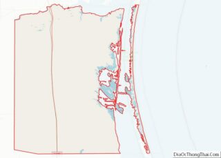
Online Interactive Map
Click on ![]() to view map in "full screen" mode.
to view map in "full screen" mode.
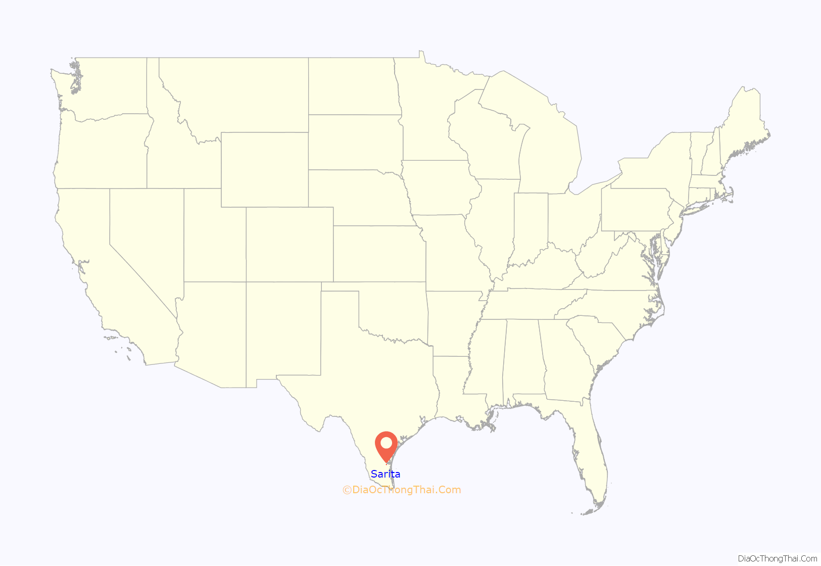
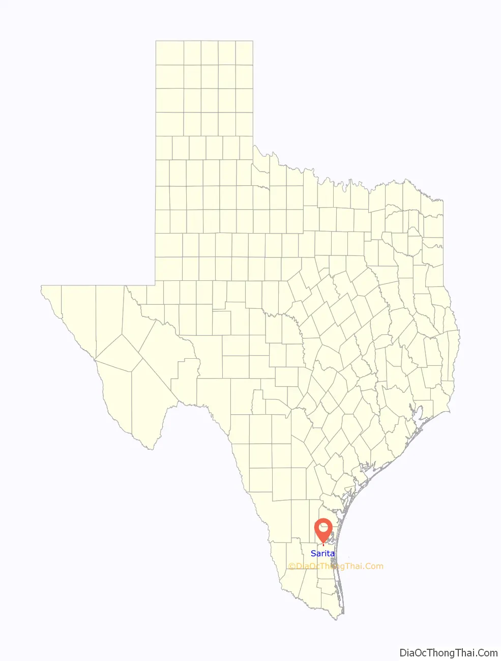
Sarita location map. Where is Sarita CDP?
History
In 1904, the town of Sarita, Texas was founded on land that had been part of Kenedy Ranch. John G. Kenedy named the town after his daughter Sarita Kenedy East. The town served the Kenedy Pasture Company and Kenedy Ranch and its employees. The company store, ranch offices, and ranch buildings have been located in Sarita. Most of the residents were somehow involved in the Kenedy businesses, either as employees or tenant cotton farmers from Kenedy Pasture Company. The Kenedy Ranch Museum, with art and artifacts about the history of the Kenedy family in South Texas, opened in 2003 in the newly restored Kenedy Pasture Company building.
“Occupation” hoax
In 2014, a fake news website called National Report published an article claiming that a militia of “over one hundred armed La Raza militants” had occupied Sarita, forcing original residents out of their homes and using the town as a base of operations. The hoax report circled on the Internet.
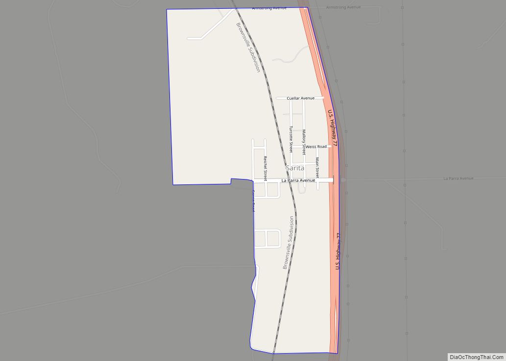
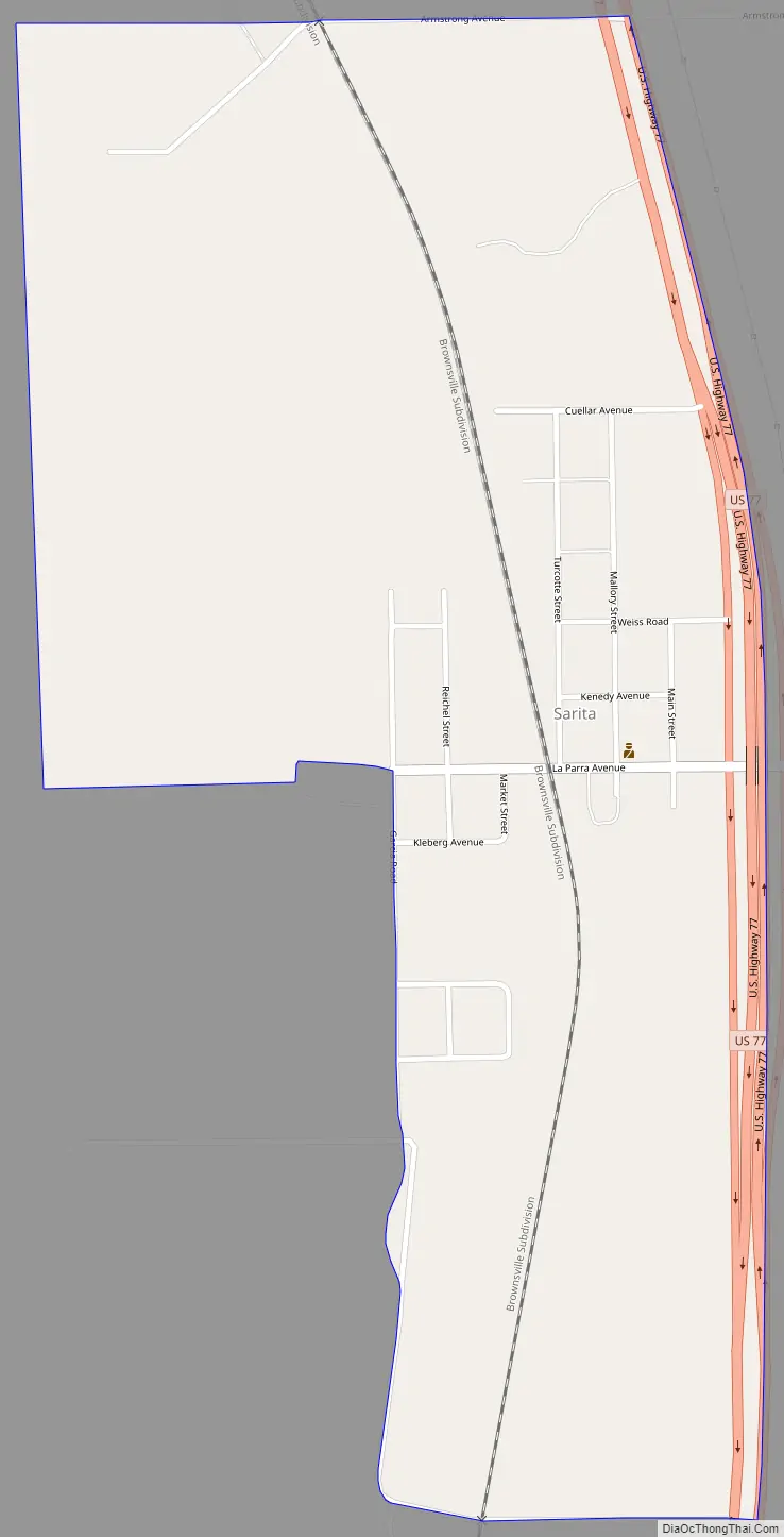
Sarita Road Map
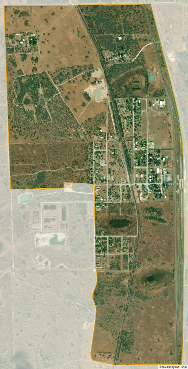
Sarita city Satellite Map
Geography
Sarita is located in northern Kenedy County at 27°13′18″N, 97°47′21″W. It is along U.S. Route 77, 21 miles (34 km) south of Kingsville, 61 miles (98 km) south of Corpus Christi, and 74 miles (119 km) north of Harlingen. The United States Border Patrol Sarita checkpoint on US 77 is located some 14 miles (23 km) south of the town of Sarita.
Cityscape
Gary Cartwright of Texas Monthly said that Sarita’s only landmarks were a green sign reading “Sarita”, a water tower, and a blinking yellow light. Sarita has an elementary school and a Catholic church. The only lodging establishment, as of 2004, is a bed and breakfast operated by justice of the peace Patti Fain. The only venue that sells soft drinks is a vending machine at the Kenedy County courthouse. Sarita does not have any convenience stores, shops, or cafes. The nearest grocery store is in Kingsville, though there are convenience stores at gas stations in Riviera 5 miles (8 km) to the north along US 77. The nearest major medical center is in Corpus Christi.
Climate
The climate in this area is characterized by hot, humid summers and generally mild to cool winters. According to the Köppen climate classification system, Sarita has a humid subtropical climate, abbreviated “Cfa” on climate maps.
See also
Map of Texas State and its subdivision:- Anderson
- Andrews
- Angelina
- Aransas
- Archer
- Armstrong
- Atascosa
- Austin
- Bailey
- Bandera
- Bastrop
- Baylor
- Bee
- Bell
- Bexar
- Blanco
- Borden
- Bosque
- Bowie
- Brazoria
- Brazos
- Brewster
- Briscoe
- Brooks
- Brown
- Burleson
- Burnet
- Caldwell
- Calhoun
- Callahan
- Cameron
- Camp
- Carson
- Cass
- Castro
- Chambers
- Cherokee
- Childress
- Clay
- Cochran
- Coke
- Coleman
- Collin
- Collingsworth
- Colorado
- Comal
- Comanche
- Concho
- Cooke
- Coryell
- Cottle
- Crane
- Crockett
- Crosby
- Culberson
- Dallam
- Dallas
- Dawson
- Deaf Smith
- Delta
- Denton
- Dewitt
- Dickens
- Dimmit
- Donley
- Duval
- Eastland
- Ector
- Edwards
- El Paso
- Ellis
- Erath
- Falls
- Fannin
- Fayette
- Fisher
- Floyd
- Foard
- Fort Bend
- Franklin
- Freestone
- Frio
- Gaines
- Galveston
- Garza
- Gillespie
- Glasscock
- Goliad
- Gonzales
- Gray
- Grayson
- Gregg
- Grimes
- Guadalupe
- Hale
- Hall
- Hamilton
- Hansford
- Hardeman
- Hardin
- Harris
- Harrison
- Hartley
- Haskell
- Hays
- Hemphill
- Henderson
- Hidalgo
- Hill
- Hockley
- Hood
- Hopkins
- Houston
- Howard
- Hudspeth
- Hunt
- Hutchinson
- Irion
- Jack
- Jackson
- Jasper
- Jeff Davis
- Jefferson
- Jim Hogg
- Jim Wells
- Johnson
- Jones
- Karnes
- Kaufman
- Kendall
- Kenedy
- Kent
- Kerr
- Kimble
- King
- Kinney
- Kleberg
- Knox
- La Salle
- Lamar
- Lamb
- Lampasas
- Lavaca
- Lee
- Leon
- Liberty
- Limestone
- Lipscomb
- Live Oak
- Llano
- Loving
- Lubbock
- Lynn
- Madison
- Marion
- Martin
- Mason
- Matagorda
- Maverick
- McCulloch
- McLennan
- McMullen
- Medina
- Menard
- Midland
- Milam
- Mills
- Mitchell
- Montague
- Montgomery
- Moore
- Morris
- Motley
- Nacogdoches
- Navarro
- Newton
- Nolan
- Nueces
- Ochiltree
- Oldham
- Orange
- Palo Pinto
- Panola
- Parker
- Parmer
- Pecos
- Polk
- Potter
- Presidio
- Rains
- Randall
- Reagan
- Real
- Red River
- Reeves
- Refugio
- Roberts
- Robertson
- Rockwall
- Runnels
- Rusk
- Sabine
- San Augustine
- San Jacinto
- San Patricio
- San Saba
- Schleicher
- Scurry
- Shackelford
- Shelby
- Sherman
- Smith
- Somervell
- Starr
- Stephens
- Sterling
- Stonewall
- Sutton
- Swisher
- Tarrant
- Taylor
- Terrell
- Terry
- Throckmorton
- Titus
- Tom Green
- Travis
- Trinity
- Tyler
- Upshur
- Upton
- Uvalde
- Val Verde
- Van Zandt
- Victoria
- Walker
- Waller
- Ward
- Washington
- Webb
- Wharton
- Wheeler
- Wichita
- Wilbarger
- Willacy
- Williamson
- Wilson
- Winkler
- Wise
- Wood
- Yoakum
- Young
- Zapata
- Zavala
- Alabama
- Alaska
- Arizona
- Arkansas
- California
- Colorado
- Connecticut
- Delaware
- District of Columbia
- Florida
- Georgia
- Hawaii
- Idaho
- Illinois
- Indiana
- Iowa
- Kansas
- Kentucky
- Louisiana
- Maine
- Maryland
- Massachusetts
- Michigan
- Minnesota
- Mississippi
- Missouri
- Montana
- Nebraska
- Nevada
- New Hampshire
- New Jersey
- New Mexico
- New York
- North Carolina
- North Dakota
- Ohio
- Oklahoma
- Oregon
- Pennsylvania
- Rhode Island
- South Carolina
- South Dakota
- Tennessee
- Texas
- Utah
- Vermont
- Virginia
- Washington
- West Virginia
- Wisconsin
- Wyoming