Map of Valle Verde CDP

Map of Valle Verde CDP

Valle Verde is a census-designated place (CDP) in Webb County, Texas, United States. This was a new CDP formed from parts of the Ranchitos Las Lomas CDP prior to the 2010 census. Although a new CDP the population was listed as zero. It is one of several colonias in the county. Valle Verde CDP overview: … Read more

Map of Valle Hermoso CDP

Map of Valle Hermoso CDP

Valle Hermoso is a census-designated place (CDP) in Starr County, Texas, United States. Although a new CDP for the 2010 census the population was listed as zero. Valle Hermoso CDP overview: Name: Valle Hermoso CDP LSAD Code: 57 LSAD Description: CDP (suffix) State: Texas County: Starr County Total Area: 0.5 sq mi (1 km²) Land Area: 0.5 sq mi (1 km²) … Read more

Map of Vanderbilt CDP, Texas

Map of Vanderbilt CDP, Texas

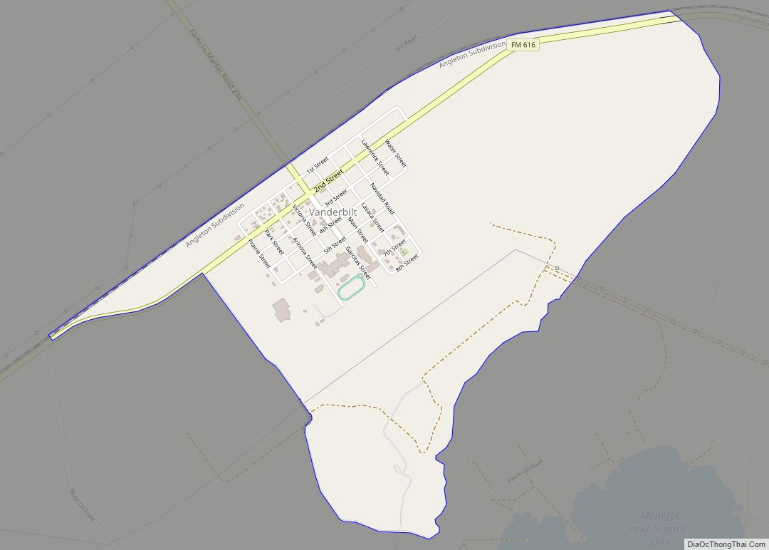
Vanderbilt is an unincorporated community and census-designated place (CDP) in Jackson County, Texas, United States. The population was 395 at the 2010 census. Vanderbilt CDP overview: Name: Vanderbilt CDP LSAD Code: 57 LSAD Description: CDP (suffix) State: Texas County: Jackson County Elevation: 39 ft (12 m) Total Area: 1.9 sq mi (4.9 km²) Land Area: 1.9 sq mi (4.9 km²) Water Area: 0.0 sq mi … Read more

Map of Van city

Map of Van city, Texas

Van is a city located in southeastern Van Zandt County, Texas, United States about 26 miles northwest of Tyler. Its population was 2,632 at the 2010 census. The town draws its name from an early settler and school teacher Henry Vance. Van city overview: Name: Van city LSAD Code: 25 LSAD Description: city (suffix) State: … Read more

Map of Van Vleck CDP

Map of Van Vleck CDP

Van Vleck is a census-designated place (CDP) in Matagorda County, Texas, United States. The population is one of the few areas with positive growth in Matagorda County. The 2010 census showed a 25% increase with 1,844 people (versus 1,411 at the 2000 census). Although near Bay City, TX the site of Van Vleck falls outside … Read more

Map of Van Horn town

Map of Van Horn town

Van Horn is a town in and the seat of Culberson County, Texas, United States. According to the 2010 census, Van Horn had a population of 2,063, down from 2,435 at the 2000 census. The 2020 census results detailed a decline in population to 1,941. Van Horn’s official newspaper is The Van Horn Advocate. The … Read more

Map of Van Alstyne city

Map of Van Alstyne city

Van Alstyne is a city in Grayson and Collin Counties in the U.S. state of Texas. The population was 3,046 at the 2010 census, up from 2,502 at the 2000 census. The Grayson County portion of Van Alstyne is part of the Sherman–Denison Metropolitan Statistical Area. Van Alstyne city overview: Name: Van Alstyne city LSAD … Read more

Map of Valley View city, Texas

Map of Valley View city, Texas

Valley View is a city in Cooke County, Texas, United States. Its population was 757 at the 2010 census. Valley View city overview: Name: Valley View city LSAD Code: 25 LSAD Description: city (suffix) State: Texas County: Cooke County Elevation: 722 ft (220 m) Total Area: 3.54 sq mi (9.17 km²) Land Area: 3.54 sq mi (9.16 km²) Water Area: 0.00 sq mi (0.01 km²) Total … Read more

Map of Valley Mills city

Map of Valley Mills city

Valley Mills is a city in Bosque and McLennan counties in central Texas, United States. The population was 1,203 at the 2010 census. The McLennan County portion of Valley Mills is part of the Waco Metropolitan Statistical Area. Valley Mills city overview: Name: Valley Mills city LSAD Code: 25 LSAD Description: city (suffix) State: Texas … Read more

Map of Valle Vista CDP, Texas

Map of Valle Vista CDP, Texas

Valle Vista is a census-designated place (CDP) in Starr County, Texas, United States. It is a new CDP formed from part of the old La Victoria CDP prior to the 2010 census with a population of 469. Valle Vista CDP overview: Name: Valle Vista CDP LSAD Code: 57 LSAD Description: CDP (suffix) State: Texas County: … Read more

Map of Villa Pancho CDP

Map of Villa Pancho CDP

Villa Pancho is a census-designated place (CDP) in Cameron County, Texas, United States. The population was 788 at the 2010 census, up from 386 at the 2000 census. It is part of the Brownsville–Harlingen Metropolitan Statistical Area. Villa Pancho CDP overview: Name: Villa Pancho CDP LSAD Code: 57 LSAD Description: CDP (suffix) State: Texas County: … Read more

Map of Villa del Sol CDP

Map of Villa del Sol CDP

Villa del Sol is a census-designated place (CDP) in Cameron County, Texas, United States. The population was 175 at the 2010 census. It is part of the Brownsville–Harlingen Metropolitan Statistical Area. Villa del Sol CDP overview: Name: Villa del Sol CDP LSAD Code: 57 LSAD Description: CDP (suffix) State: Texas County: Cameron County Elevation: 30 ft … Read more