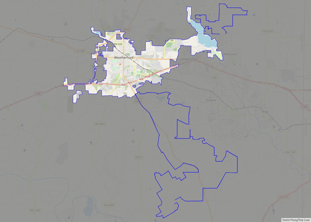
Map of Weir city, Texas

Map of Weir city, Texas

Weir is a city in Williamson County, Texas, United States. The population was 450 at the 2010 census. Weir city overview: Name: Weir city LSAD Code: 25 LSAD Description: city (suffix) State: Texas County: Williamson County Elevation: 682 ft (208 m) Total Area: 1.64 sq mi (4.25 km²) Land Area: 1.62 sq mi (4.19 km²) Water Area: 0.03 sq mi (0.07 km²) Total Population: 450 Population … Read more

Map of Weinert city

Map of Weinert city

Weinert is a city in Haskell County, Texas, United States. The population was 172 at the 2010 census. Weinert city overview: Name: Weinert city LSAD Code: 25 LSAD Description: city (suffix) State: Texas County: Haskell County Elevation: 1,526 ft (465 m) Total Area: 0.48 sq mi (1.25 km²) Land Area: 0.48 sq mi (1.25 km²) Water Area: 0.00 sq mi (0.00 km²) Total Population: 172 Population … Read more

Map of Weimar city

Map of Weimar city

Weimar (/ˈwaɪmər/ or, by many non-locals, /ˈwiːmər/) is a city in Colorado County, Texas, United States. The population was 2,076 at the 2020 census. It is part of the Texas-German belt region and was founded and named by German emigrants after the city of Weimar, Germany. In 1873 the town was founded in anticipation that … Read more

Map of Webster city, Texas

Map of Webster city, Texas

Webster is a city in the U.S. state of Texas located in Harris County, within the Houston–The Woodlands–Sugar Land metropolitan area. Its population was 12,499 at the 2020 U.S. census. Webster city overview: Name: Webster city LSAD Code: 25 LSAD Description: city (suffix) State: Texas County: Harris County Elevation: 23 ft (7 m) Total Area: 6.62 sq mi (17.15 km²) … Read more

Map of West Odessa CDP

Map of West Odessa CDP

West Odessa is an unincorporated area and census-designated place (CDP) in Ector County, Texas, United States, on the west side of the city of Odessa. The population was 22,707 at the 2010 census, up from 17,799 at the 2000 census. It is part of the Odessa metropolitan area. West Odessa CDP overview: Name: West Odessa … Read more

Map of West Livingston CDP

Map of West Livingston CDP

West Livingston is a census-designated place (CDP) in western Polk County, Texas, United States, located along the eastern shore of Lake Livingston 6 miles (9.7 km) west of central Livingston. The population was 8,156 at the 2020 census. West Livingston CDP overview: Name: West Livingston CDP LSAD Code: 57 LSAD Description: CDP (suffix) State: Texas County: … Read more

Map of West Lake Hills city

Map of West Lake Hills city

West Lake Hills (locally referred to as “Westlake”) is a city in Travis County, Texas, United States. The population was 3,444 at the 2020 census. The city developed rapidly in the 1970s and 1980s on the south side of the Colorado River. According to the United States Census Bureau, the city has a total area … Read more

Map of West Columbia city, Texas

Map of West Columbia city, Texas

West Columbia is a city in Brazoria County in the U.S. state of Texas. The city is centered on the intersection of Texas Highways 35 & 36, 55 miles (89 km) southwest of downtown Houston. The population was 3,644 at the 2020 census. The 1st Congress of the Republic of Texas was convened in West Columbia … Read more

Map of West Alto Bonito CDP

Map of West Alto Bonito CDP

West Alto Bonito is a census-designated place (CDP) in Starr County, Texas, United States. The population was 696 in 2010 census. Prior to the 2010 census West Alto Bonito CDP was known as Alto Bonito CDP. West Alto Bonito CDP overview: Name: West Alto Bonito CDP LSAD Code: 57 LSAD Description: CDP (suffix) State: Texas … Read more

Map of Weslaco city

Map of Weslaco city

Weslaco /ˈwɛsləˌkoʊ/ is a city in Hidalgo County, Texas, United States. As of the 2020 census the population was 41,103, and in 2020 the estimated population was 41,103. It is located at the southern tip of Texas in the Rio Grande Valley near the Mexican border, across the Rio Grande from the city of Nuevo … Read more

Map of Wells town, Texas

Map of Wells town, Texas

Wells is a town in Cherokee County, Texas, United States. The population was 790 at the 2010 census, and 853 at the 2020 U.S. census. Wells town overview: Name: Wells town LSAD Code: 43 LSAD Description: town (suffix) State: Texas County: Cherokee County Elevation: 325 ft (99 m) Total Area: 1.92 sq mi (4.96 km²) Land Area: 1.92 sq mi (4.96 km²) Water … Read more

Map of Wells Branch CDP

Map of Wells Branch CDP

Wells Branch is a census-designated place (CDP) in Travis County, Texas, United States. The population was 14,000 at the 2020 census. Wells Branch CDP overview: Name: Wells Branch CDP LSAD Code: 57 LSAD Description: CDP (suffix) State: Texas County: Travis County Elevation: 820 ft (250 m) Total Area: 2.5 sq mi (6.6 km²) Land Area: 2.5 sq mi (6.6 km²) Water Area: 0.0 sq mi … Read more