Map of White Oak city, Texas

Map of White Oak city, Texas

White Oak is a city in Gregg County, Texas, United States. It was incorporated in 1960. The population was 6,225 as of 2020. White Oak city overview: Name: White Oak city LSAD Code: 25 LSAD Description: city (suffix) State: Texas County: Gregg County Elevation: 413 ft (126 m) Total Area: 9.14 sq mi (23.67 km²) Land Area: 9.09 sq mi (23.54 km²) Water … Read more

Map of White Deer town

Map of White Deer town

White Deer is a town in Carson County, Texas, United States. The population was 1,000 at the 2010 census. It is part of the Amarillo metropolitan statistical area. White Deer town overview: Name: White Deer town LSAD Code: 43 LSAD Description: town (suffix) State: Texas County: Carson County Elevation: 3,366 ft (1,026 m) Total Area: 1.74 sq mi (4.51 km²) … Read more

Map of Wheeler city, Texas

Map of Wheeler city, Texas

Wheeler is a city, and the county seat of Wheeler County, Texas, United States, located on the eastern border of the Texas Panhandle. The population was last reported at 1,592 in the 2010 census. Wheeler city overview: Name: Wheeler city LSAD Code: 25 LSAD Description: city (suffix) State: Texas County: Wheeler County Elevation: 2,507 ft (764 m) … Read more

Map of Wharton city, Texas

Map of Wharton city, Texas

Wharton is a city in and the county seat of Wharton County, Texas, United States. This city is 60 mi (97 km) southwest of Houston. Its population was 8,832 at the 2010 census and 8,627 at the 2020 census. Wharton is located on the Colorado River of Texas. U.S. Highway 59 passes west of it. Wharton city … Read more

Map of Westworth Village city

Map of Westworth Village city

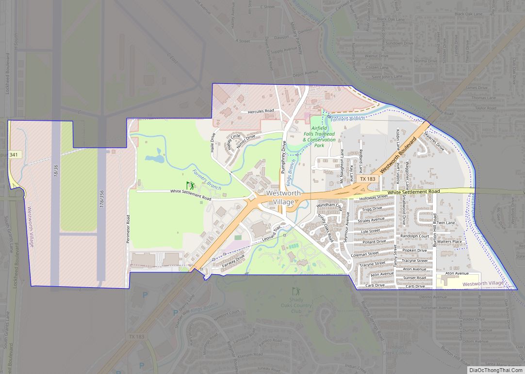
Westworth Village is a city in Tarrant County, Texas, United States. The population was 2,472 at the 2010 census. Westworth Village city overview: Name: Westworth Village city LSAD Code: 25 LSAD Description: city (suffix) State: Texas County: Tarrant County Elevation: 568 ft (173 m) Total Area: 2.08 sq mi (5.40 km²) Land Area: 2.07 sq mi (5.37 km²) Water Area: 0.01 sq mi (0.03 km²) Total … Read more

Map of Westwood Shores CDP

Map of Westwood Shores CDP

Westwood Shores is a census-designated place (CDP) in Trinity County, Texas, United States. This was a new CDP for the 2010 census with a population of 1,162, increasing to 1,239 at the 2020 census. Westwood Shores CDP overview: Name: Westwood Shores CDP LSAD Code: 57 LSAD Description: CDP (suffix) State: Texas County: Trinity County Total … Read more

Map of Westway CDP

Map of Westway CDP

Westway is a census-designated place (CDP) in El Paso County, Texas, United States. The population was 4,188 at the 2010 census. It is part of the El Paso Metropolitan Statistical Area. It is located east of Interstate 10 about 2 miles (3 km) from the New Mexico – Texas state line. The ZIP Code encompassing the … Read more

Map of Westover Hills town

Map of Westover Hills town

Westover Hills is a town in Tarrant County, Texas, United States. The population was 682 at the 2010 census. In 2000, Westover Hills was the wealthiest location in Texas by per capita income and the 12th highest-income place in the United States. It has since been surpassed in Texas by both Piney Point Village and … Read more

Map of Weston city, Texas

Map of Weston city, Texas

Weston is a city in Collin County, Texas, United States. The population was 563 at the 2010 census, and 283 at the 2020 United States census. Weston city overview: Name: Weston city LSAD Code: 25 LSAD Description: city (suffix) State: Texas County: Collin County Elevation: 748 ft (228 m) Total Area: 4.52 sq mi (11.71 km²) Land Area: 4.49 sq mi (11.62 km²) … Read more

Map of Weston Lakes city

Map of Weston Lakes city

Weston Lakes is a city in Fort Bend County, Texas, United States, within Greater Houston. Residents voted to incorporate the community in an election held on May 10, 2008. At the time of incorporation, there were about 2,300 residents living in Weston Lakes. The population was 3,853 as of the 2020 census. Weston Lakes city … Read more

Map of White Settlement city

Map of White Settlement city

White Settlement is a city in Tarrant County, Texas, United States, and a northwestern suburb of Fort Worth. The population was 17,851 in 2019. White Settlement city overview: Name: White Settlement city LSAD Code: 25 LSAD Description: city (suffix) State: Texas County: Tarrant County Elevation: 666 ft (203 m) Total Area: 5.04 sq mi (13.05 km²) Land Area: 5.04 sq mi (13.05 km²) … Read more

Map of Wildwood CDP, Texas

Map of Wildwood CDP, Texas

Wildwood is a gated community and census-designated place in Hardin and Tyler counties, Texas, United States. As of the 2020 census it had a population of 1,121. The Hardin county portion of Wildwood is part of the Beaumont–Port Arthur Metropolitan Statistical Area. Wildwood CDP overview: Name: Wildwood CDP LSAD Code: 57 LSAD Description: CDP (suffix) … Read more