Map of Bonanza Hills CDP

Map of Bonanza Hills CDP

Bonanza Hills is a census-designated place in Webb County, Texas, United States. The population was 37 at the 2010 census. This was a new CDP formed from parts of the Botines CDP and additional area prior to the 2010 census. Bonanza Hills CDP overview: Name: Bonanza Hills CDP LSAD Code: 57 LSAD Description: CDP (suffix) … Read more

Map of Bolivar Peninsula CDP

Map of Bolivar Peninsula CDP

Bolivar Peninsula (/ˈbɒlɪvər/ BOL-i-vər) is a census-designated place (CDP) in Galveston County, Texas, United States. The population was 2,417 at the 2010 census. The communities of Port Bolivar, Crystal Beach, Caplen, Gilchrist, and High Island are located on Bolivar Peninsula. Bolivar Peninsula CDP overview: Name: Bolivar Peninsula CDP LSAD Code: 57 LSAD Description: CDP (suffix) … Read more

Map of Boling CDP

Map of Boling CDP

Boling is a census-designated place (CDP) in Wharton County, Texas, United States. This was a new CDP formed from parts of the Boling-Iago CDP prior to the 2010 census with a population of 1122. Boling CDP overview: Name: Boling CDP LSAD Code: 57 LSAD Description: CDP (suffix) State: Texas County: Wharton County Total Area: 4.7 sq mi … Read more

Map of Bowie city, Texas

Map of Bowie city, Texas

Bowie (/ˈbuːi/ BOO-ee) is a town in Montague County, Texas, United States. The population was 5,218 at the 2010 census. Bowie city overview: Name: Bowie city LSAD Code: 25 LSAD Description: city (suffix) State: Texas County: Montague County Elevation: 1,129 ft (344 m) Total Area: 5.54 sq mi (14.36 km²) Land Area: 5.52 sq mi (14.29 km²) Water Area: 0.02 sq mi (0.06 km²) Total Population: … Read more

Map of Bovina city

Map of Bovina city

Bovina is a city in Parmer County, Texas, United States. The population was 1,868 at the 2010 census. Bovina city overview: Name: Bovina city LSAD Code: 25 LSAD Description: city (suffix) State: Texas County: Parmer County Elevation: 4,068 ft (1,240 m) Total Area: 1.18 sq mi (3.05 km²) Land Area: 1.18 sq mi (3.05 km²) Water Area: 0.00 sq mi (0.00 km²) Total Population: 1,699 Population … Read more

Map of Botines CDP

Map of Botines CDP

Botines is a census-designated place (CDP) in Webb County, Texas, United States. The population was 117 at the 2010 census. Botines is located 5 miles (8.0 km) north of Laredo. The town’s name originates from the Spanish term botín, which means buskin, boot, or legging. It is one of several colonias in the county. Botines CDP … Read more

Map of Borger city

Map of Borger city

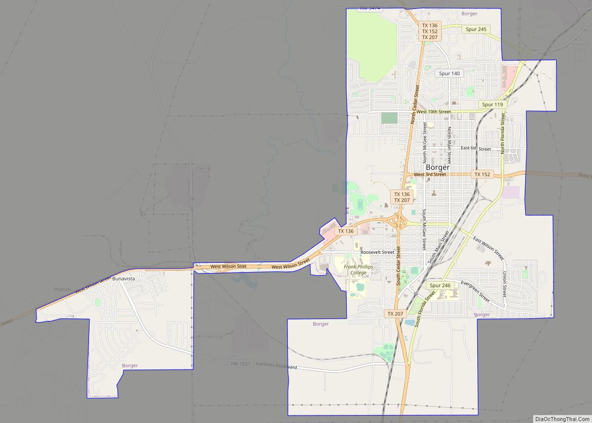
Borger (/ˈbɔːrɡər/ BOR-gər) is the largest city in Hutchinson County, Texas, United States. The population was 12,551 at the 2020 census. Borger is named for businessman Asa Philip “Ace” Borger, who also established the Hutchinson County seat of Stinnett and several other small towns in Texas and Oklahoma. Borger city overview: Name: Borger city LSAD … Read more

Map of Booker town

Map of Booker town

Booker is a town in Lipscomb and Ochiltree counties in the U.S. state of Texas. It was named for B.F. Booker, a civil engineer for the Panhandle and Santa Fe Railway. The population was 1,516 at the 2010 census. Booker town overview: Name: Booker town LSAD Code: 43 LSAD Description: town (suffix) State: Texas County: … Read more

Map of Bremond city

Map of Bremond city

Bremond (/ˈbriːmɒnd/ BREE-mond) is a city in Robertson County, Texas, United States. The population was 858 at the 2020 census. Bremond city overview: Name: Bremond city LSAD Code: 25 LSAD Description: city (suffix) State: Texas County: Robertson County Elevation: 459 ft (140 m) Total Area: 0.89 sq mi (2.29 km²) Land Area: 0.89 sq mi (2.29 km²) Water Area: 0.00 sq mi (0.00 km²) Total Population: … Read more

Map of Breckenridge city, Texas

Map of Breckenridge city, Texas

Breckenridge is a city in Stephens County, Texas, United States. The estimated population was 5,349 as of February 2021. It is the county seat of Stephens County. The mayor is Bob Sims. Breckenridge was a stop on the since defunct Wichita Falls and Southern Railroad, one of the properties of Frank Kell and Joseph A. … Read more

Map of Brazos Country city

Map of Brazos Country city

Brazos Country is a residential community in Austin County, Texas. Brazos Country city overview: Name: Brazos Country city LSAD Code: 25 LSAD Description: city (suffix) State: Texas County: Austin County Incorporated: 2000 Total Area: 2.00 sq mi (5.19 km²) Land Area: 1.95 sq mi (5.06 km²) Water Area: 0.05 sq mi (0.13 km²) Total Population: 469 Population Density: 242.70/sq mi (93.71/km²) ZIP code: 77474 FIPS … Read more

Map of Brazos Bend city

Map of Brazos Bend city

Brazos Bend city overview: Name: Brazos Bend city LSAD Code: 25 LSAD Description: city (suffix) State: Texas County: Hood County FIPS code: 4810087 Online Interactive Map Brazos Bend online map. Source: Basemap layers from Google Map, Open Street Map (OSM), Arcgisonline, Wmflabs. Boundary Data from Database of Global Administrative Areas. Brazos Bend location map. Where … Read more