Breckenridge is a city in Stephens County, Texas, United States. The estimated population was 5,349 as of February 2021. It is the county seat of Stephens County. The mayor is Bob Sims.
Breckenridge was a stop on the since defunct Wichita Falls and Southern Railroad, one of the properties of Frank Kell and Joseph A. Kemp of Wichita Falls, Texas. The line was thereafter operated until 1969 by the Chicago, Rock Island and Pacific Railroad.
Former Texas State Representative Carl Isett of Lubbock (District 84) was born in Breckenridge in 1957.
Dallas Cowboys legend Gerald M. “Jerry” Tubbs was an honor graduate student and played center at Breckenridge High School. He was part of two Texas state-championship football teams in 1951 and 1952. He played in three high-school all-star games, and was a unanimous Texas All-State selection in 1952. In 1971, Tubbs was inducted into the Texas High School Football Hall of Fame.
| Name: | Breckenridge city |
|---|---|
| LSAD Code: | 25 |
| LSAD Description: | city (suffix) |
| State: | Texas |
| County: | Stephens County |
| Elevation: | 1,204 ft (367 m) |
| Total Area: | 4.20 sq mi (10.88 km²) |
| Land Area: | 4.20 sq mi (10.87 km²) |
| Water Area: | 0.00 sq mi (0.01 km²) |
| Total Population: | 5,780 |
| Population Density: | 1,292.11/sq mi (498.89/km²) |
| ZIP code: | 76424 |
| Area code: | 254 |
| FIPS code: | 4810132 |
| GNISfeature ID: | 1372709 |
| Website: | breckenridgetx.gov |
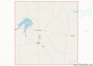
Online Interactive Map
Click on ![]() to view map in "full screen" mode.
to view map in "full screen" mode.
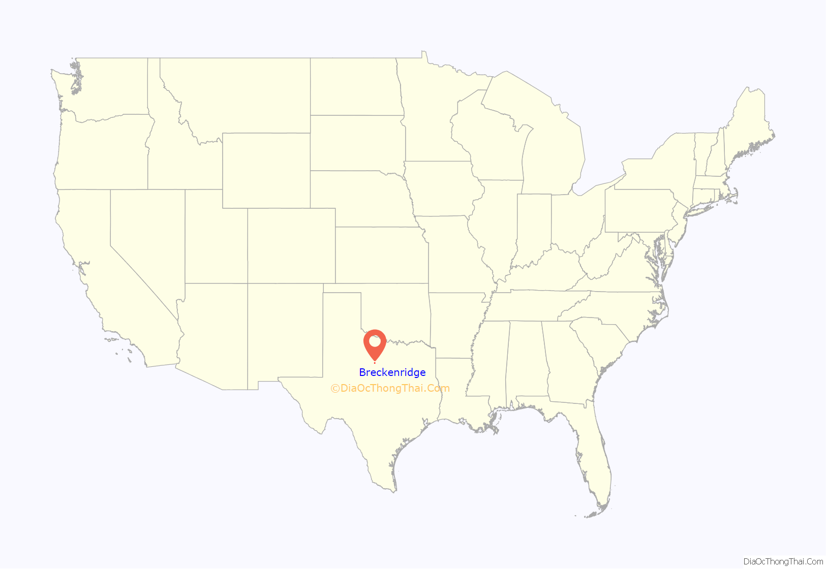
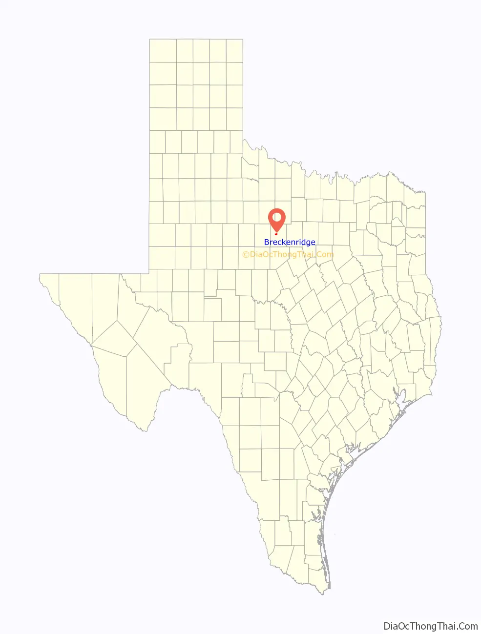
Breckenridge location map. Where is Breckenridge city?
History
The town of Breckenridge originated in 1854 as Picketville, either named after the structure of its early homes or after rancher Bill Pickett, who lived in the area at the time. In 1876, Stephens County was established, and its territory included Picketville. The town was renamed “Breckenridge” after former U.S. Vice President and Confederate Army General John C. Breckinridge, though with an altered spelling.
Breckenridge was a major oil producer in the early 1920s. The population jumped from around 1000 to 5000 in under five years. Briefly, it was the home of legendary figure of the Old West, John “Doc” Holliday. Breckenridge’s boomtown era was well documented by the hundreds of photographs of pioneer photographer Basil Clemons.
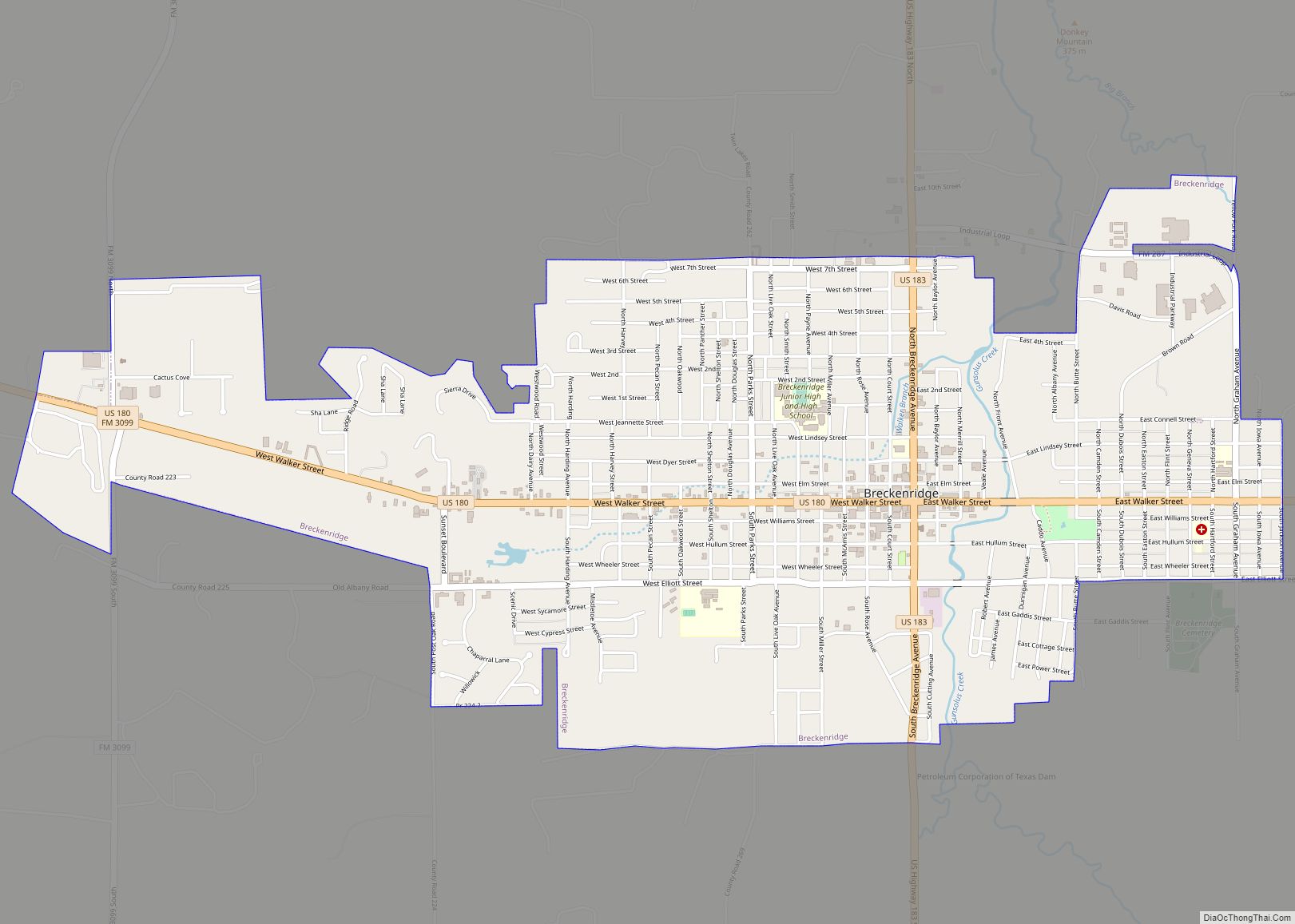
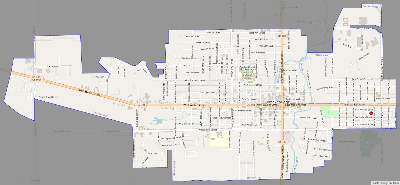
Breckenridge Road Map
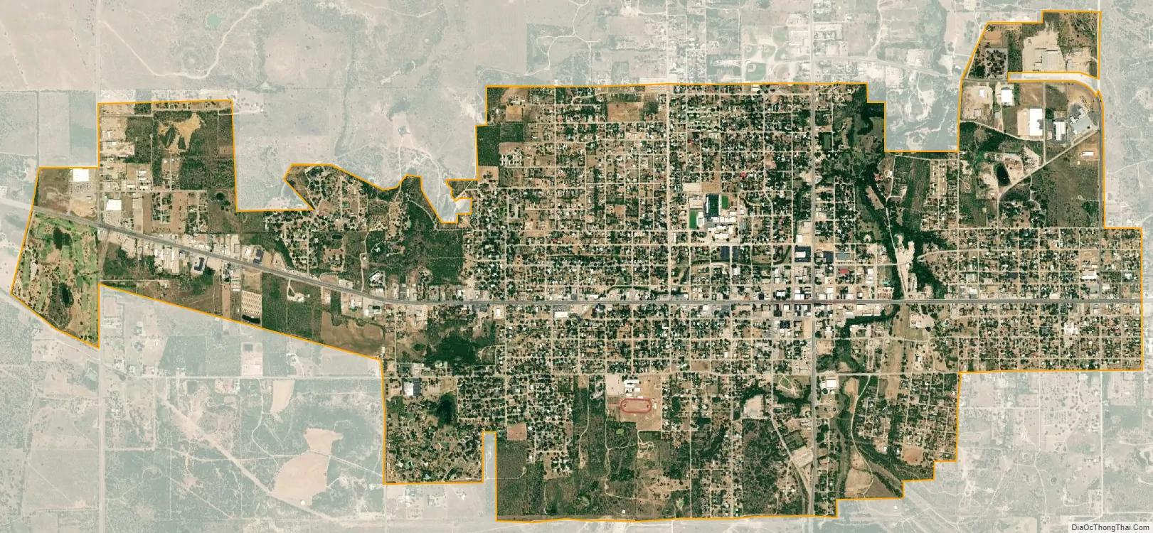
Breckenridge city Satellite Map
Geography
Breckenridge is located at 32°45′24″N 98°54′20″W / 32.75667°N 98.90556°W / 32.75667; -98.90556 (32.756793, –98.905580).
According to the United States Census Bureau, the city has a total area of 4.2 sq mi (10.8 km), of which 0.24% is covered by water.
See also
Map of Texas State and its subdivision:- Anderson
- Andrews
- Angelina
- Aransas
- Archer
- Armstrong
- Atascosa
- Austin
- Bailey
- Bandera
- Bastrop
- Baylor
- Bee
- Bell
- Bexar
- Blanco
- Borden
- Bosque
- Bowie
- Brazoria
- Brazos
- Brewster
- Briscoe
- Brooks
- Brown
- Burleson
- Burnet
- Caldwell
- Calhoun
- Callahan
- Cameron
- Camp
- Carson
- Cass
- Castro
- Chambers
- Cherokee
- Childress
- Clay
- Cochran
- Coke
- Coleman
- Collin
- Collingsworth
- Colorado
- Comal
- Comanche
- Concho
- Cooke
- Coryell
- Cottle
- Crane
- Crockett
- Crosby
- Culberson
- Dallam
- Dallas
- Dawson
- Deaf Smith
- Delta
- Denton
- Dewitt
- Dickens
- Dimmit
- Donley
- Duval
- Eastland
- Ector
- Edwards
- El Paso
- Ellis
- Erath
- Falls
- Fannin
- Fayette
- Fisher
- Floyd
- Foard
- Fort Bend
- Franklin
- Freestone
- Frio
- Gaines
- Galveston
- Garza
- Gillespie
- Glasscock
- Goliad
- Gonzales
- Gray
- Grayson
- Gregg
- Grimes
- Guadalupe
- Hale
- Hall
- Hamilton
- Hansford
- Hardeman
- Hardin
- Harris
- Harrison
- Hartley
- Haskell
- Hays
- Hemphill
- Henderson
- Hidalgo
- Hill
- Hockley
- Hood
- Hopkins
- Houston
- Howard
- Hudspeth
- Hunt
- Hutchinson
- Irion
- Jack
- Jackson
- Jasper
- Jeff Davis
- Jefferson
- Jim Hogg
- Jim Wells
- Johnson
- Jones
- Karnes
- Kaufman
- Kendall
- Kenedy
- Kent
- Kerr
- Kimble
- King
- Kinney
- Kleberg
- Knox
- La Salle
- Lamar
- Lamb
- Lampasas
- Lavaca
- Lee
- Leon
- Liberty
- Limestone
- Lipscomb
- Live Oak
- Llano
- Loving
- Lubbock
- Lynn
- Madison
- Marion
- Martin
- Mason
- Matagorda
- Maverick
- McCulloch
- McLennan
- McMullen
- Medina
- Menard
- Midland
- Milam
- Mills
- Mitchell
- Montague
- Montgomery
- Moore
- Morris
- Motley
- Nacogdoches
- Navarro
- Newton
- Nolan
- Nueces
- Ochiltree
- Oldham
- Orange
- Palo Pinto
- Panola
- Parker
- Parmer
- Pecos
- Polk
- Potter
- Presidio
- Rains
- Randall
- Reagan
- Real
- Red River
- Reeves
- Refugio
- Roberts
- Robertson
- Rockwall
- Runnels
- Rusk
- Sabine
- San Augustine
- San Jacinto
- San Patricio
- San Saba
- Schleicher
- Scurry
- Shackelford
- Shelby
- Sherman
- Smith
- Somervell
- Starr
- Stephens
- Sterling
- Stonewall
- Sutton
- Swisher
- Tarrant
- Taylor
- Terrell
- Terry
- Throckmorton
- Titus
- Tom Green
- Travis
- Trinity
- Tyler
- Upshur
- Upton
- Uvalde
- Val Verde
- Van Zandt
- Victoria
- Walker
- Waller
- Ward
- Washington
- Webb
- Wharton
- Wheeler
- Wichita
- Wilbarger
- Willacy
- Williamson
- Wilson
- Winkler
- Wise
- Wood
- Yoakum
- Young
- Zapata
- Zavala
- Alabama
- Alaska
- Arizona
- Arkansas
- California
- Colorado
- Connecticut
- Delaware
- District of Columbia
- Florida
- Georgia
- Hawaii
- Idaho
- Illinois
- Indiana
- Iowa
- Kansas
- Kentucky
- Louisiana
- Maine
- Maryland
- Massachusetts
- Michigan
- Minnesota
- Mississippi
- Missouri
- Montana
- Nebraska
- Nevada
- New Hampshire
- New Jersey
- New Mexico
- New York
- North Carolina
- North Dakota
- Ohio
- Oklahoma
- Oregon
- Pennsylvania
- Rhode Island
- South Carolina
- South Dakota
- Tennessee
- Texas
- Utah
- Vermont
- Virginia
- Washington
- West Virginia
- Wisconsin
- Wyoming