Map of Caney City town

Map of Caney City town

Caney City is a city in Henderson County, Texas, United States. The population was 217 at the 2010 census. Caney City town overview: Name: Caney City town LSAD Code: 43 LSAD Description: town (suffix) State: Texas County: Henderson County Elevation: 354 ft (108 m) Total Area: 1.15 sq mi (2.98 km²) Land Area: 1.15 sq mi (2.98 km²) Water Area: 0.00 sq mi (0.00 km²) Total … Read more

Map of Canadian city, Texas

Map of Canadian city, Texas

Canadian is a city in, and the county seat of, Hemphill County, Texas, United States. The population was 2,649 at the 2010 census, up from 2,233 in 2000. It is named for the nearby Canadian River, a tributary of the Arkansas River. Incorporated in 1908, Canadian is sometimes called “the oasis of the High Plains”. … Read more

Map of Campo Verde CDP

Map of Campo Verde CDP

Campo Verde is a census-designated place (CDP) in Starr County, Texas, United States. It is a new CDP formed from part of the La Rosita CDP prior to the 2010 census with a population of 132. Campo Verde CDP overview: Name: Campo Verde CDP LSAD Code: 57 LSAD Description: CDP (suffix) State: Texas County: Starr … Read more

Map of Campbell city, Texas

Map of Campbell city, Texas

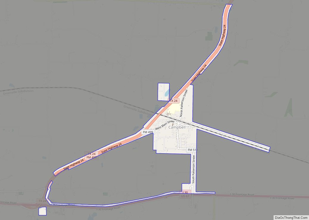
Campbell is a city in Hunt County, in the U.S. state of Texas. The population was 638 at the 2010 census, down from 734 at the 2000 census. Campbell city overview: Name: Campbell city LSAD Code: 25 LSAD Description: city (suffix) State: Texas County: Hunt County Elevation: 591 ft (180 m) Total Area: 1.34 sq mi (3.47 km²) Land Area: … Read more

Map of Camp Wood city

Map of Camp Wood city

Camp Wood is a city in Real County, Texas, USA, in the Texas Hill Country, which is part of the Edwards Plateau. The population was 706 at the 2010 census. Camp Wood city overview: Name: Camp Wood city LSAD Code: 25 LSAD Description: city (suffix) State: Texas County: Real County Elevation: 1,457 ft (444 m) Total Area: … Read more

Map of Camp Swift CDP

Map of Camp Swift CDP

Camp Swift is a census-designated place (CDP) in Bastrop County, Texas, United States. The population was 7,943 at the 2020 census. Camp Swift began as a United States Army training base built in 1942. It is named after Major General Eben Swift. Camp Swift CDP overview: Name: Camp Swift CDP LSAD Code: 57 LSAD Description: … Read more

Map of Carthage city, Texas

Map of Carthage city, Texas

Carthage is a city and the county seat of Panola County, Texas, United States. This city is situated in deep East Texas, 20 miles west of the Louisiana state line. Its population was 6,569 at the 2020 census. Carthage city overview: Name: Carthage city LSAD Code: 25 LSAD Description: city (suffix) State: Texas County: Panola … Read more

Map of Carrizo Springs city

Map of Carrizo Springs city

Carrizo Springs is the largest city in and the county seat of Dimmit County, Texas, United States. The population was 5,368 at the 2010 census. (2018 estimate 5,470). The name of the town is derived from the local springs, which were named by the Spanish for the cane grass that once grew around them. It … Read more

Map of Carrizo Hill CDP

Map of Carrizo Hill CDP

Carrizo Hill is a census-designated place (CDP) in Dimmit County, in the U.S. state of Texas, United States. The population was 582 at the 2010 census. Carrizo Hill CDP overview: Name: Carrizo Hill CDP LSAD Code: 57 LSAD Description: CDP (suffix) State: Texas County: Dimmit County Elevation: 630 ft (190 m) Total Area: 0.5 sq mi (1.3 km²) Land Area: … Read more

Map of Carmine city

Map of Carmine city

Carmine (/ˈkɑːrmiːn/ KAR-meen) is a city in Fayette County, Texas, United States. The population was 250 at the 2010 census. The Texas Basketball Museum in Carmine is operated by Coach Bob Springer at the corner of Augsburg Avenue and Hauptstrasse Street. The collection highlights players who advance to the professional ranks as well as high … Read more

Map of Carlsbad CDP, Texas

Map of Carlsbad CDP, Texas

Carlsbad is a census-designated place and unincorporated community in northwest Tom Green County, Texas, United States. It lies along U.S. Route 87 northwest of the city of San Angelo, the county seat of Tom Green County. Its elevation is 2,024 feet (617 m). Although Carlsbad is unincorporated, it has a post office, with the ZIP code of … Read more

Map of Carl's Corner town

Map of Carl’s Corner town

Carl’s Corner is a town in Hill County, Texas, United States. The population was 173 at the 2010 census. The town was founded by, and named after, Carl Cornelius, a local truck stop owner and long-time friend of Willie Nelson. Cornelius founded the town for the purpose of legalizing alcohol sales in the otherwise mostly-dry … Read more