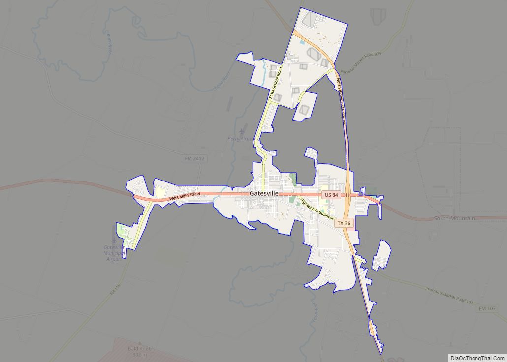
Map of Gholson city

Map of Gholson city

Gholson is a city in McLennan County, Texas, United States. The population was 1,061 at the 2010 census. It is part of the Waco Metropolitan Statistical Area. The area was settled in the 1840s, and was early known as Sardis. The name Gholson, after early settlers, brothers Benjamin and Samuel Gholson, came into gradual use, … Read more

Map of Geronimo CDP, Texas

Map of Geronimo CDP, Texas

Geronimo is an unincorporated community and census-designated place (CDP) in Guadalupe County, Texas, United States. The population was 1,032 at the 2010 census, up from 619 at the 2000 census. It is part of the San Antonio Metropolitan Statistical Area. Geronimo CDP overview: Name: Geronimo CDP LSAD Code: 57 LSAD Description: CDP (suffix) State: Texas … Read more

Map of Goliad city

Map of Goliad city

Goliad (/ˈɡoʊliæd/ GOH-lee-ad) is a city in Goliad County, Texas, United States. It is known for the 1836 Goliad massacre during the Texas Revolution. It had a population of 1,620 at the 2020 census. Founded on the San Antonio River, it is the county seat of Goliad County. It is part of the Victoria, Texas, … Read more

Map of Goldthwaite city

Map of Goldthwaite city

Goldthwaite is a town and the county seat of Mills County, Texas, United States. The population was 1,878 at the 2010 census. Goldthwaite city overview: Name: Goldthwaite city LSAD Code: 25 LSAD Description: city (suffix) State: Texas County: Mills County Elevation: 1,572 ft (479 m) Total Area: 2.07 sq mi (5.35 km²) Land Area: 2.02 sq mi (5.23 km²) Water Area: 0.05 sq mi (0.12 km²) … Read more

Map of Goldsmith city

Map of Goldsmith city

Goldsmith is a city in Ector County, Texas, United States. The population was 257 at the 2010 census. It is part of the Odessa Metropolitan Statistical Area. Goldsmith city overview: Name: Goldsmith city LSAD Code: 25 LSAD Description: city (suffix) State: Texas County: Ector County Elevation: 3,140 ft (957 m) Total Area: 0.32 sq mi (0.84 km²) Land Area: 0.32 sq mi … Read more

Map of Godley city, Texas

Map of Godley city, Texas

Godley is a city in northwestern Johnson County, Texas, United States, in the Dallas–Fort Worth metroplex. It is on Texas State Highway 171, Farm Roads 2331 and 917, and the tracks of the Atchison, Topeka and Santa Fe Railway northwest of Cleburne. The population was 1,009 in 2010, up from 879 in 2000. Godley city … Read more

Map of Glidden CDP, Texas

Map of Glidden CDP, Texas

Glidden is an unincorporated community and census-designated place in Colorado County, Texas, United States. As of the 2010 census it had a population of 661. It lies just north of Interstate 10 and 3 miles (5 km) to the west of Columbus. Glidden CDP overview: Name: Glidden CDP LSAD Code: 57 LSAD Description: CDP (suffix) State: … Read more

Map of Glenn Heights city

Map of Glenn Heights city

Glenn Heights is a city in Dallas and Ellis counties in the U.S. state of Texas. The population was 11,278 at the 2010 census, and 15,819 in 2020. Glenn Heights city overview: Name: Glenn Heights city LSAD Code: 25 LSAD Description: city (suffix) State: Texas County: Dallas County, Ellis County Elevation: 676 ft (206 m) Total Area: … Read more

Map of Glen Rose city

Map of Glen Rose city

Glen Rose is a city in and the county seat of Somervell County, Texas, United States. As of the 2012 census estimate, the city population was 2,502. Glen Rose city overview: Name: Glen Rose city LSAD Code: 25 LSAD Description: city (suffix) State: Texas County: Somervell County Elevation: 620 ft (189 m) Total Area: 3.92 sq mi (10.16 km²) Land … Read more

Map of Gladewater city

Map of Gladewater city

Gladewater is a city in Gregg and Upshur counties in the U.S. state of Texas with a 2020 census population of 6,134. In the early 20th century, Gladewater was an oil boom town. In 1995, the Texas Legislature proclaimed it the “Antique Capital of East Texas.” Gladewater city overview: Name: Gladewater city LSAD Code: 25 … Read more

Map of Girard CDP, Texas

Map of Girard CDP, Texas

Girard is an unincorporated community and census-designated place (CDP) in Kent County, Texas, United States. The population was 50 at the 2010 census. Girard CDP overview: Name: Girard CDP LSAD Code: 57 LSAD Description: CDP (suffix) State: Texas County: Kent County Elevation: 2,116 ft (645 m) Total Area: 1.45 sq mi (3.76 km²) Land Area: 1.45 sq mi (3.76 km²) Water Area: 0.0 sq mi … Read more

Map of Gilmer city

Map of Gilmer city

Gilmer is a city in, and the county seat of, Upshur County, Texas. It is best known for being the home of the East Texas Yamboree and the birthplace of popular music singers Don Henley of the Eagles band and Johnny Mathis, as well as blues musician Freddie King. Its population was 4,843 at the … Read more