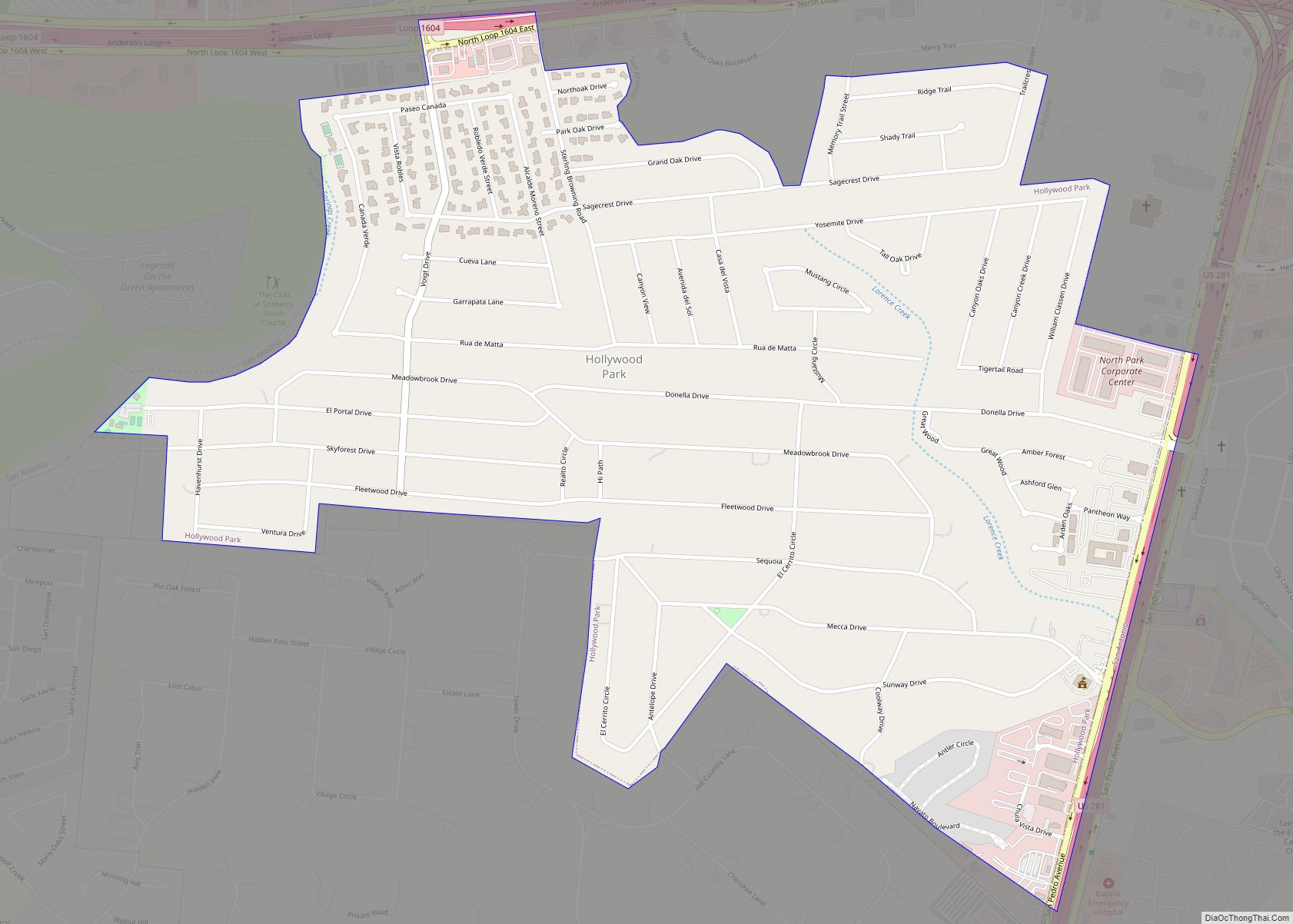
Map of Holland town, Texas

Map of Holland town, Texas

Holland is a city in Bell County, Texas, United States. The population was 1,075 at the 2020 census. The center of population of Texas is located in Holland. It is part of the Killeen–Temple–Fort Hood metropolitan statistical area. Holland town overview: Name: Holland town LSAD Code: 43 LSAD Description: town (suffix) State: Texas County: Bell … Read more

Map of Holiday Lakes town, Texas

Map of Holiday Lakes town, Texas

Holiday Lakes is a town in Brazoria County, Texas, United States. The population was 991 at the 2020 census. Holiday Lakes town overview: Name: Holiday Lakes town LSAD Code: 43 LSAD Description: town (suffix) State: Texas County: Brazoria County Elevation: 36 ft (11 m) Total Area: 0.98 sq mi (2.53 km²) Land Area: 0.88 sq mi (2.28 km²) Water Area: 0.10 sq mi (0.25 km²) Total … Read more

Map of Holiday Beach CDP

Map of Holiday Beach CDP

Holiday Beach is an unincorporated community and census-designated place in Aransas County, Texas, United States. As of the 2010 census it had a population of 514. This was a new CDP for the 2010 census. Holiday Beach CDP overview: Name: Holiday Beach CDP LSAD Code: 57 LSAD Description: CDP (suffix) State: Texas County: Aransas County … Read more

Map of Hitchcock city, Texas

Map of Hitchcock city, Texas

Hitchcock is a city in Galveston County, Texas, United States. The population was 6,961 at the 2010 census. Hitchcock city overview: Name: Hitchcock city LSAD Code: 25 LSAD Description: city (suffix) State: Texas County: Galveston County Incorporated: January 30, 1960 Elevation: 16 ft (4.9 m) Total Area: 91.48 sq mi (236.94 km²) Land Area: 60.43 sq mi (156.51 km²) Water Area: 31.05 sq mi (80.43 km²) … Read more

Map of Horseshoe Bend CDP, Texas

Map of Horseshoe Bend CDP, Texas

Horseshoe Bend is a census-designated place in Parker County, Texas, United States. This was a new CDP for the 2010 census with a population of 789. Horseshoe Bend CDP overview: Name: Horseshoe Bend CDP LSAD Code: 57 LSAD Description: CDP (suffix) State: Texas County: Parker County Elevation: 718 ft (219 m) Total Area: 1.73 sq mi (4.5 km²) Land Area: … Read more

Map of Horseshoe Bay city

Map of Horseshoe Bay city

Horseshoe Bay is a city in Llano and Burnet counties in the U.S. state of Texas. Situated on Lake Lyndon B. Johnson and the south branch of the Colorado River, it is known in the region for its golf courses, hotel and resort, and water sports. Prior to its incorporation in September 2005, it was … Read more

Map of Hornsby Bend CDP

Map of Hornsby Bend CDP

Hornsby Bend is a census-designated place (CDP) in Travis County, Texas, United States. This was a new CDP for the 2010 census with a population of 6,791, increasing to 12,168 in 2020. The area was named after early settler and Republic of Texas era postmaster Reuben Hornsby. His great-grandson, Baseball Hall of Famer Rogers Hornsby, … Read more

Map of Horizon City city

Map of Horizon City

Horizon City is a city in El Paso County, Texas, United States. As of the 2020 United States Census, its population was 22,489, reflecting an increase of 5,754 from the 16,735 counted in the 2010 Census. Horizon City overview: Name: Horizon City LSAD Code: 25 LSAD Description: city (suffix) State: Texas County: El Paso County … Read more

Map of Hooks city

Map of Hooks city

Hooks is a city in Bowie County, Texas. It is part of the Texarkana metropolitan area and had a population of 2,518 at the 2020 U.S. census. Hooks city overview: Name: Hooks city LSAD Code: 25 LSAD Description: city (suffix) State: Texas County: Bowie County Elevation: 374 ft (114 m) Total Area: 2.09 sq mi (5.41 km²) Land Area: 2.09 sq mi … Read more

Map of Honey Grove city

Map of Honey Grove city

Honey Grove is a city in Fannin County, Texas, United States. Honey Grove bills itself as “The Sweetest Town in Texas”. The population was 1,668 at the 2010 census. Honey Grove city overview: Name: Honey Grove city LSAD Code: 25 LSAD Description: city (suffix) State: Texas County: Fannin County Elevation: 673 ft (205 m) Total Area: 3.02 sq mi … Read more

Map of Hondo city

Map of Hondo city

Hondo is a city in and the county seat of Medina County, Texas, United States. According to the 2010 Census, the population was 8,803. It is part of the San Antonio Metropolitan Statistical Area. Hondo city overview: Name: Hondo city LSAD Code: 25 LSAD Description: city (suffix) State: Texas County: Medina County Elevation: 892 ft (272 m) … Read more

Map of Hubbard city, Texas

Map of Hubbard city, Texas

Hubbard is a city in Hill County, Texas, United States. It was named for Texas Governor Richard B. Hubbard. The city is 42 miles (68 km) northeast of Waco, Texas.The population was 1,423 at the 2010 census, down from 1,586 at the 2000 census. Hubbard city overview: Name: Hubbard city LSAD Code: 25 LSAD Description: city … Read more