Map of Indian Hills CDP, Texas

Map of Indian Hills CDP, Texas

Indian Hills is a census-designated place (CDP) in Hidalgo County, Texas, United States. At the 2010 United States Census, the population was 2,591. It is part of the McAllen–Edinburg–Mission Metropolitan Statistical Area. Indian Hills CDP overview: Name: Indian Hills CDP LSAD Code: 57 LSAD Description: CDP (suffix) State: Texas County: Hidalgo County Elevation: 66 ft (20 m) … Read more

Map of Imperial CDP, Texas

Map of Imperial CDP, Texas

Imperial is a census-designated place (CDP) in Pecos County, Texas, United States. The population was 278 at the 2010 census. Imperial CDP overview: Name: Imperial CDP LSAD Code: 57 LSAD Description: CDP (suffix) State: Texas County: Pecos County Elevation: 2,392 ft (729 m) Total Area: 4.2 sq mi (11.0 km²) Land Area: 4.2 sq mi (11.0 km²) Water Area: 0.0 sq mi (0.0 km²) Total Population: … Read more

Map of Impact town

Map of Impact town

Impact is a town in Taylor County, Texas, United States. The population was 35 at the 2010 census. It is part of the Abilene, Texas Metropolitan Statistical Area. Impact town overview: Name: Impact town LSAD Code: 43 LSAD Description: town (suffix) State: Texas County: Taylor County Elevation: 1,670 ft (509 m) Total Area: 0.09 sq mi (0.23 km²) Land Area: … Read more

Map of Iglesia Antigua CDP

Map of Iglesia Antigua CDP

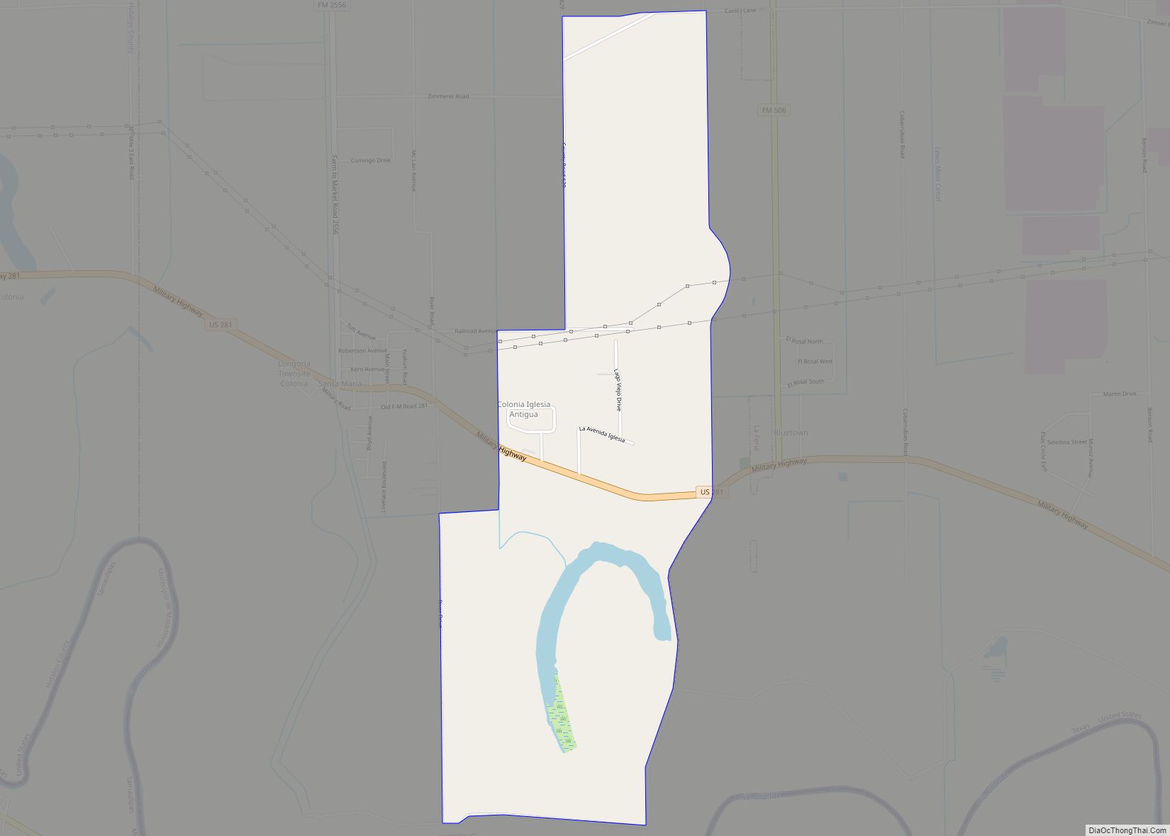
Iglesia Antigua is a census-designated place (CDP) in Cameron County, in the U.S. state of Texas. The population was 413 at the 2010 census. Prior to the 2010 census the community was part of the Bluetown-Iglesia Antigua CDP. It is part of the Brownsville–Harlingen Metropolitan Statistical Area. Iglesia Antigua CDP overview: Name: Iglesia Antigua CDP … Read more

Map of Idalou city

Map of Idalou city

Idalou is a city in Lubbock County, Texas, United States. It is located 7 miles (11 km) northeast of Lubbock near the intersection of Farm to Market Road 400 and US 62/US 82/SH 114. The population was 2,250 at the 2010 census. It is part of the Lubbock Metropolitan Statistical Area. Idalou city overview: Name: Idalou … Read more

Map of Iago CDP

Map of Iago CDP

Iago (Pron: Eye-a’-go) is a census-designated place (CDP) in Wharton County, Texas, United States. This was a new CDP formed from parts of the Boling-Iago CDP prior to the 2010 census with a population of 161. Iago CDP overview: Name: Iago CDP LSAD Code: 57 LSAD Description: CDP (suffix) State: Texas County: Wharton County Total … Read more

Map of Huxley city, Texas

Map of Huxley city, Texas

Huxley is a city in Shelby County, Texas, United States. The population was 385 at the 2010 census. Huxley city overview: Name: Huxley city LSAD Code: 25 LSAD Description: city (suffix) State: Texas County: Shelby County Elevation: 279 ft (85 m) Total Area: 2.08 sq mi (5.40 km²) Land Area: 2.04 sq mi (5.29 km²) Water Area: 0.04 sq mi (0.11 km²) Total Population: 385 Population … Read more

Map of Hutto city

Map of Hutto city

Hutto is a city in Williamson County, Texas, United States. It is part of the Austin–Round Rock metropolitan area. The population was 27,577 at the 2020 census. Hutto city overview: Name: Hutto city LSAD Code: 25 LSAD Description: city (suffix) State: Texas County: Williamson County Elevation: 663 ft (202 m) Total Area: 12.39 sq mi (32.09 km²) Land Area: 12.35 sq mi … Read more

Map of Hutchins city, Texas

Map of Hutchins city, Texas

Hutchins is a city in Dallas County, Texas, United States. Its population was 5,338 at the 2010 census. Hutchins city overview: Name: Hutchins city LSAD Code: 25 LSAD Description: city (suffix) State: Texas County: Dallas County Elevation: 466 ft (142 m) Total Area: 9.31 sq mi (24.11 km²) Land Area: 9.09 sq mi (23.54 km²) Water Area: 0.22 sq mi (0.57 km²)  2.35% Total Population: 5,338 … Read more

Map of Hurst city, Texas

Map of Hurst city, Texas

Hurst is a city in the U.S. state of Texas located in the densely populated portion of northeastern Tarrant County and is part of the Dallas–Fort Worth metropolitan area. It is considered a Dallas and Fort Worth suburb and is part of the Mid-Cities region. It is 13 miles from the Dallas/Fort Worth International Airport. … Read more

Map of Iowa Colony village

Map of Iowa Colony village

Iowa Colony is an incorporated Home Rule City in Brazoria County, Texas, United States, in the Houston metropolitan area. As of the 2010 census the city has a population of 1,170. Iowa Colony village overview: Name: Iowa Colony village LSAD Code: 47 LSAD Description: village (suffix) State: Texas County: Brazoria County Founded: 1908 Incorporated: 1973 … Read more

Map of Iola city, Texas

Map of Iola city, Texas

Iola is a city in Grimes County, Texas, United States, on Farm Road 39 and the Burlington-Rock Island Railway, at the headwaters of Ragan Creek in northwest Grimes County. As of the 2010 census the population was 401. Iola city overview: Name: Iola city LSAD Code: 25 LSAD Description: city (suffix) State: Texas County: Grimes … Read more