Map of Kingsland CDP, Texas

Map of Kingsland CDP, Texas

Kingsland is a census-designated place (CDP) in Llano County, Texas, United States. The population was 6,030 at the 2010 census, up from 4,584 at the 2000 census. Texas Ranch to Market Road 1431 runs through the community. Kingsland CDP overview: Name: Kingsland CDP LSAD Code: 57 LSAD Description: CDP (suffix) State: Texas County: Llano County … Read more

Map of Kingsbury city, Texas

Map of Kingsbury city, Texas

Kingsbury is a city in eastern Guadalupe County, Texas, United States. Kingsbury was a Census-designated place in 2010, when the census reported a population of 782. It is part of the San Antonio Metropolitan Statistical Area. The election to incorporate Kingsbury into a Type-C Liberty City passed by a landslide vote of 66–2 on May … Read more

Map of Kilgore city, Texas

Map of Kilgore city, Texas

Kilgore is a city in Gregg and Rusk counties in the eastern part of the U.S. state of Texas. Over three-fourths of the city limits is located in Gregg County, the remainder in Rusk County. The population was 12,975 at the 2010 census and 13,376 at the 2020 census. From the age of six, Van … Read more

Map of Kerrville city

Map of Kerrville city

Kerrville is a city in, and the county seat of, Kerr County, Texas, United States. The population of Kerrville was 24,278 at the 2020 census. Kerrville is named after James Kerr, a major in the Texas Revolution, and friend of settler-founder Joshua Brown, who settled in the area to start a shingle-making camp. Being nestled … Read more

Map of Kermit city

Map of Kermit city, Texas

Kermit is a city in and the county seat of Winkler County, Texas, United States. The population was 5,708 at the 2010 census. The city was named after Kermit Roosevelt following a visit by his father, President Theodore Roosevelt, to the county. Kermit city overview: Name: Kermit city LSAD Code: 25 LSAD Description: city (suffix) … Read more

Map of Kerens city

Map of Kerens city

Kerens is a city in Navarro County, Texas, United States. The population was 1,573 at the 2010 census. Kerens city overview: Name: Kerens city LSAD Code: 25 LSAD Description: city (suffix) State: Texas County: Navarro County Elevation: 371 ft (113 m) Total Area: 2.50 sq mi (6.48 km²) Land Area: 2.50 sq mi (6.48 km²) Water Area: 0.00 sq mi (0.01 km²) Total Population: 1,573 Population … Read more

Map of Kennedale city

Map of Kennedale city

Kennedale is a city in Tarrant County, Texas, United States. The city had a population of 8,543 as of 2018. Kennedale city overview: Name: Kennedale city LSAD Code: 25 LSAD Description: city (suffix) State: Texas County: Tarrant County Elevation: 630 ft (192 m) Total Area: 6.62 sq mi (17.15 km²) Land Area: 6.61 sq mi (17.12 km²) Water Area: 0.01 sq mi (0.03 km²) Total Population: … Read more

Map of Kennard city, Texas

Map of Kennard city, Texas

Kennard (/kəˈnɑːrd/ kə-NARD) is a city in Houston County, Texas, United States. Its population was 337 at the 2010 census. The main street is Texas State Highway 7. Kennard city overview: Name: Kennard city LSAD Code: 25 LSAD Description: city (suffix) State: Texas County: Houston County Elevation: 361 ft (110 m) Total Area: 1.30 sq mi (3.36 km²) Land Area: … Read more

Map of Kenefick town

Map of Kenefick town

Kenefick is a town in Liberty County, Texas, United States. The population was 563 at the 2010 census. Kenefick town overview: Name: Kenefick town LSAD Code: 43 LSAD Description: town (suffix) State: Texas County: Liberty County Elevation: 66 ft (20 m) Total Area: 1.56 sq mi (4.03 km²) Land Area: 1.55 sq mi (4.02 km²) Water Area: 0.004 sq mi (0.01 km²) Total Population: 563 Population … Read more

Map of Kingsville city, Texas

Map of Kingsville city, Texas

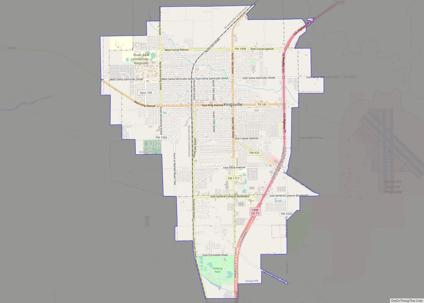
Kingsville is a city in the southern region of the U.S. state of Texas and the county seat of Kleberg County. Located on the U.S. Route 77 corridor between Corpus Christi and Harlingen, Kingsville is the principal city of the Kingsville Micropolitan Statistical Area, which is part of the larger Corpus Christi-Kingsville Combined Statistical Area. … Read more

Map of Krugerville city

Map of Krugerville city

Krugerville is a city in Denton County, Texas, United States. The population was 1,766 in 2020. Krugerville city overview: Name: Krugerville city LSAD Code: 25 LSAD Description: city (suffix) State: Texas County: Denton County Elevation: 686 ft (209 m) Total Area: 1.32 sq mi (3.42 km²) Land Area: 1.32 sq mi (3.42 km²) Water Area: 0.00 sq mi (0.00 km²) Total Population: 1,766 Population Density: 1,389.86/sq mi … Read more

Map of Kress city

Map of Kress city

Kress is a city in Swisher County, Texas, United States. The population was 715 at the 2010 census. Kress city overview: Name: Kress city LSAD Code: 25 LSAD Description: city (suffix) State: Texas County: Swisher County Elevation: 3,471 ft (1,058 m) Total Area: 0.57 sq mi (1.48 km²) Land Area: 0.56 sq mi (1.44 km²) Water Area: 0.02 sq mi (0.04 km²) Total Population: 715 Population … Read more