Map of Live Oak city, Texas
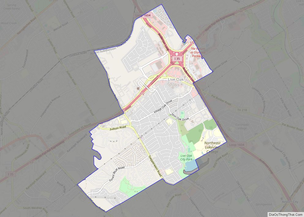
Live Oak is a city in Bexar County, Texas, United States. The population was 15,781 at the 2020 census. It is part of the San Antonio Metropolitan Statistical Area. Live Oak city overview: Name: Live Oak city LSAD Code: 25 LSAD Description: city (suffix) State: Texas County: Bexar County Elevation: 912 ft (278 m) Total Area: 4.80 sq mi ... Read more
Map of Live Oak city, Texas
Map of Littlefield city, Texas
Littlefield is a city in and the county seat of Lamb County, Texas, United States. Its population was 6,372 at the 2010 census. It is located in a significant cotton-growing region, northwest of Lubbock on the Llano Estacado just south of the Texas Panhandle. Littlefield had a large denim-manufacturing plant operated by American Cotton Growers. ... Read more
Map of Littlefield city, Texas
Map of Lolita CDP
Lolita is a census-designated place (CDP) in Jackson County, Texas, United States. The population was 555 at the 2010 census. Lolita CDP overview: Name: Lolita CDP LSAD Code: 57 LSAD Description: CDP (suffix) State: Texas County: Jackson County Elevation: 39 ft (12 m) Total Area: 2.6 sq mi (6.7 km²) Land Area: 2.6 sq mi (6.7 km²) Water Area: 0.0 sq mi (0.0 km²) Total Population: ... Read more
Map of Lolita CDP
Map of Log Cabin city
Log Cabin is a city in Henderson County, Texas, United States. The population was 714 at the 2010 census. Log Cabin city overview: Name: Log Cabin city LSAD Code: 25 LSAD Description: city (suffix) State: Texas County: Henderson County Elevation: 371 ft (113 m) Total Area: 1.06 sq mi (2.73 km²) Land Area: 1.05 sq mi (2.71 km²) Water Area: 0.01 sq mi (0.02 km²) Total ... Read more
Map of Log Cabin city
Map of Lockney town
Lockney is a town in Floyd County, Texas, United States. The population was 1,842 at the 2010 census, down from 2,056 at the 2000 census. Lockney town overview: Name: Lockney town LSAD Code: 43 LSAD Description: town (suffix) State: Texas County: Floyd County Elevation: 3,278 ft (999 m) Total Area: 1.54 sq mi (4.00 km²) Land Area: 1.54 sq mi (4.00 km²) Water ... Read more
Map of Lockney town
Map of Lockhart city, Texas
Lockhart is a city and the county seat of Caldwell County, Texas, United States. According to the 2020 census, its population was 14,379. Lockhart city overview: Name: Lockhart city LSAD Code: 25 LSAD Description: city (suffix) State: Texas County: Caldwell County Elevation: 515 ft (157 m) Total Area: 15.64 sq mi (40.50 km²) Land Area: 15.61 sq mi (40.44 km²) Water Area: 0.02 sq mi ... Read more
Map of Lockhart city, Texas
Map of Llano city
Llano (/ˈlænoʊ/ LAN-oh) is a city in Llano County, Texas, United States. As of 2010, the city population was 3,232. It is the county seat of Llano County. Llano has been described as the “deer capital of Texas”, with the single highest density of white-tailed deer in the United States. Llano city overview: Name: Llano ... Read more
Map of Llano city
Map of Llano Grande CDP
Llano Grande (Spanish “Great Plain”) is a census-designated place (CDP) in Hidalgo County, Texas. The population was 3,008 at the 2010 United States Census. It is part of the McAllen–Edinburg–Mission Metropolitan Statistical Area. Llano Grande means “Big Plain” in Spanish. Nearby Llano Grande State Park is popular with bird watchers and the supposed site of ... Read more
Map of Llano Grande CDP
Map of Longview city, Texas
Longview is a city in the U.S. state of Texas, and county seat of Gregg County which is named for Confederate General John Gregg. Longview is located in East Texas, where Interstate 20 and U.S. highways 80 and 259 converge just north of the Sabine River. According to the 2020 U.S. census, the city had ... Read more
Map of Longview city, Texas
Map of Longoria CDP
Longoria is a census-designated place (CDP) in Starr County, Texas, United States. This was a new CDP for the 2010 census with a population of 92. Longoria CDP overview: Name: Longoria CDP LSAD Code: 57 LSAD Description: CDP (suffix) State: Texas County: Starr County Total Area: 92 FIPS code: 4843822 Online Interactive Map Longoria online ... Read more
Map of Longoria CDP
Map of Lone Star city
Lone Star is a city in Morris County, Texas, United States. Its population was 1,581 at the 2010 census. Lone Star city overview: Name: Lone Star city LSAD Code: 25 LSAD Description: city (suffix) State: Texas County: Morris County Elevation: 348 ft (106 m) Total Area: 2.00 sq mi (5.18 km²) Land Area: 1.98 sq mi (5.12 km²) Water Area: 0.02 sq mi (0.05 km²) Total ... Read more
Map of Lone Star city
Map of Lone Oak city, Texas
Lone Oak is a city in Hunt County, Texas, United States. The population was 598 at the 2010 census, up from 521 at the 2000 census. Lone Oak city overview: Name: Lone Oak city LSAD Code: 25 LSAD Description: city (suffix) State: Texas County: Hunt County Elevation: 564 ft (172 m) Total Area: 1.11 sq mi (2.88 km²) Land Area: ... Read more
Map of Lone Oak city, Texas