Map of Matagorda CDP
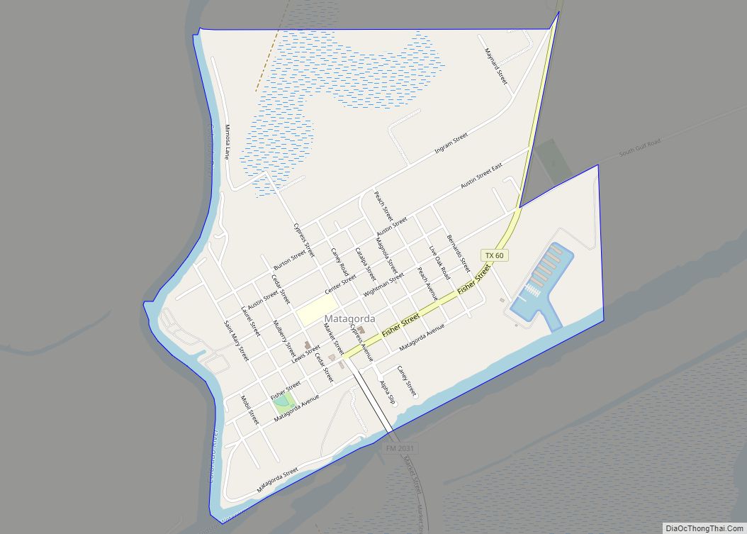
Matagorda (/ˈmætəˈɡɔːrdə/ (listen)) is a census-designated place in Matagorda County, Texas. It is located near the mouth of the Colorado River on the upper Texas coast in the United States. In 2020, its population was 313. Matagorda is primarily a tourist town, with commercial and recreational fishing being the top industries. About 23 miles (37 km) ... Read more
Map of Matagorda CDP
Map of Matador town
Matador is a town in and the county seat of Motley County, Texas, United States. Its population was 607 at the 2010 census. In 1891, it was established by and named for the Matador Ranch. It is located 95 miles (153 km) east of Lubbock, Texas. Matador town overview: Name: Matador town LSAD Code: 43 LSAD ... Read more
Map of Matador town
Map of Mason city, Texas
Mason is a city in, and the county seat of, Mason County, Texas, United States. The city is an agricultural community on Comanche Creek southwest of Mason Mountain, on the Edwards Plateau and part of the Llano Uplift. Its population was 2,114 at the 2010 census. Mason city overview: Name: Mason city LSAD Code: 25 ... Read more
Map of Mason city, Texas
Map of Martinez CDP, Texas
Martinez is a census-designated place (CDP) in Starr County, Texas, United States. This was a new CDP for the 2010 census with a population of 69. Martinez CDP overview: Name: Martinez CDP LSAD Code: 57 LSAD Description: CDP (suffix) State: Texas County: Starr County Total Area: 0.1 sq mi (0.3 km²) Land Area: 0.1 sq mi (0.3 km²) Water Area: 0.0 sq mi ... Read more
Map of Martinez CDP, Texas
Map of McKinney Acres CDP
McKinney Acres is a census-designated place (CDP) in Andrews County, Texas, United States. The population was 815 at the 2010 census. This was a new CDP for the 2010 census. McKinney Acres CDP overview: Name: McKinney Acres CDP LSAD Code: 57 LSAD Description: CDP (suffix) State: Texas County: Andrews County Elevation: 3,175 ft (968 m) Total Area: ... Read more
Map of McKinney Acres CDP
Map of McGregor city, Texas
McGregor is a city in McLennan and Coryell counties in the U.S. state of Texas. The population was 5,338 at the 2020 census. McGregor lies in two counties, as well as two metropolitan areas. The McLennan County portion of the city is part of the Waco Metropolitan Statistical Area, while the small portion that lies ... Read more
Map of McGregor city, Texas
Map of Megargel town, Texas
Megargel (/ˈmiːɡɑːrɡəl/ MEE-gar-gəl) is a town in Archer County, Texas, United States. It is part of the Wichita Falls, Texas metropolitan statistical area. Its population was 203 at the 2010 census. The town is named for Roy C. Megargel, the president of the railroad that developed the town. Megargel town overview: Name: Megargel town LSAD ... Read more
Map of Megargel town, Texas
Map of Medina CDP, Texas
Medina is a census-designated place (CDP) in Zapata County, Texas, United States. The population was 3,935 at the 2010 census. Medina CDP overview: Name: Medina CDP LSAD Code: 57 LSAD Description: CDP (suffix) State: Texas County: Zapata County Elevation: 397 ft (121 m) Total Area: 1.8 sq mi (4.6 km²) Land Area: 1.8 sq mi (4.6 km²) Water Area: 0.0 sq mi (0.0 km²) Total Population: ... Read more
Map of Medina CDP, Texas
Map of Meadows Place city
Meadows Place is a city located in Fort Bend County in the U.S. state of Texas within the Houston–Sugar Land–Baytown metropolitan area. As of the 2020 U.S. Census, the city population was 4,767. Meadows Place was part of Stafford‘s extraterritorial jurisdiction prior to incorporation on November 14, 1983. Meadows Place was incorporated as Meadows, but ... Read more
Map of Meadows Place city
Map of Meadowlakes city
Meadowlakes is a city in Burnet County, Texas, United States. The population was 1,777 at the 2010 census. Meadowlakes city overview: Name: Meadowlakes city LSAD Code: 25 LSAD Description: city (suffix) State: Texas County: Burnet County Elevation: 804 ft (245 m) Total Area: 0.78 sq mi (2.01 km²) Land Area: 0.76 sq mi (1.97 km²) Water Area: 0.02 sq mi (0.04 km²) Total Population: 1,777 Population ... Read more
Map of Meadowlakes city
Map of Meadow town, Texas
Meadow is a town in Terry County, Texas, United States. The population was 593 at the 2010 census. Meadow town overview: Name: Meadow town LSAD Code: 43 LSAD Description: town (suffix) State: Texas County: Terry County Elevation: 3,333 ft (1,016 m) Total Area: 1.61 sq mi (4.16 km²) Land Area: 1.61 sq mi (4.16 km²) Water Area: 0.00 sq mi (0.00 km²) Total Population: 593 Population ... Read more
Map of Meadow town, Texas
Map of McQueeney CDP
McQueeney is an unincorporated community and census-designated place (CDP) in Guadalupe County, Texas, United States. The population was 2,545 at the 2010 census. It is part of the San Antonio Metropolitan Statistical Area. McQueeney CDP overview: Name: McQueeney CDP LSAD Code: 57 LSAD Description: CDP (suffix) State: Texas County: Guadalupe County Elevation: 548 ft (167 m) Total ... Read more
Map of McQueeney CDP