Map of Mila Doce CDP

Map of Mila Doce CDP

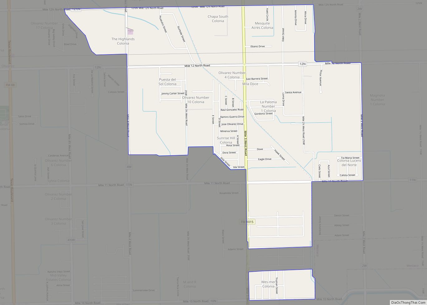
Mila Doce (“Mile Twelve” in Spanish, from the name of the road it adjoins) is a census-designated place (CDP) in Hidalgo County, Texas. The population was 6,222 at the 2010 United States Census. It is part of the McAllen–Edinburg–Mission Metropolitan Statistical Area. Mila Doce CDP overview: Name: Mila Doce CDP LSAD Code: 57 LSAD Description: … Read more

Map of Mikes CDP

Map of Mikes CDP

Mikes is a census-designated place (CDP) in Starr County, Texas, United States. This was a new CDP for the 2010 census with a population of 910. Mikes CDP overview: Name: Mikes CDP LSAD Code: 57 LSAD Description: CDP (suffix) State: Texas County: Starr County Total Area: 0.1 sq mi (0.3 km²) Land Area: 0.1 sq mi (0.3 km²) Water Area: 0.0 sq mi … Read more

Map of Miguel Barrera CDP

Map of Miguel Barrera CDP

Miguel Barrera is a census-designated place (CDP) in Starr County, Texas, United States. It is a new CDP formed from part of the La Rosita CDP prior to the 2010 census with a population of 128. Miguel Barrera CDP overview: Name: Miguel Barrera CDP LSAD Code: 57 LSAD Description: CDP (suffix) State: Texas County: Starr … Read more

Map of Midway city, Texas

Map of Midway city, Texas

Midway is a city in Madison County, Texas, United States at the junction of the La Bahía Road (now Texas State Highway 21) and the Old San Antonio Road in northeastern Madison County. Midway was the birthplace of George McJunkin, who was born a slave. Midway city overview: Name: Midway city LSAD Code: 25 LSAD … Read more

Map of Midway South CDP

Map of Midway South CDP

Midway South is a census-designated place (CDP) in Hidalgo County, Texas. The population was 2,239 at the 2010 United States Census. It is part of the McAllen–Edinburg–Mission Metropolitan Statistical Area. Midway South CDP overview: Name: Midway South CDP LSAD Code: 57 LSAD Description: CDP (suffix) State: Texas County: Hidalgo County Elevation: 79 ft (24 m) Total Area: … Read more

Map of Midway North CDP

Map of Midway North CDP

Midway North is a census-designated place (CDP) in Hidalgo County, Texas. The population was 4,752 at the 2010 United States Census. It is part of the McAllen–Edinburg–Mission Metropolitan Statistical Area. Midway North CDP overview: Name: Midway North CDP LSAD Code: 57 LSAD Description: CDP (suffix) State: Texas County: Hidalgo County Elevation: 79 ft (24 m) Total Area: … Read more

Map of Midlothian city, Texas

Map of Midlothian city, Texas

Midlothian is a city in northwest Ellis County, Texas, United States. The city is 25 miles (40 km) southwest of Dallas. It is the hub for the cement industry in North Texas, as it is the home to three separate cement production facilities, as well as a steel mill. The population of Midlothian grew by 121% … Read more

Map of Miami city, Texas

Map of Miami city, Texas

Miami (/maɪˈæmə/ my-AM-ə) is a town in Roberts County, Texas, United States. It is part of the Pampa, Texas micropolitan statistical area. Its population was 597 at the 2010 census. It is the county seat of Roberts County and the only municipality in the county. Miami city overview: Name: Miami city LSAD Code: 25 LSAD … Read more

Map of Mi Ranchito Estate CDP

Map of Mi Ranchito Estate CDP

Mi Ranchito Estate is a census-designated place (CDP) in Starr County, Texas, United States. It is a new CDP for the 2010 census with a population of 281. Parts of this new CDP were formed from the former Los Villareales CDP. Mi Ranchito Estate CDP overview: Name: Mi Ranchito Estate CDP LSAD Code: 57 LSAD … Read more

Map of Mexia city

Map of Mexia city

Mexia (/məˈheɪə/ (listen) mə-HAY-ə) is a city in Limestone County, Texas, United States. The population was 6,893 at the 2020 census. The city’s motto, based on the fact that outsiders tend to mispronounce the name /ˈmɛksiə/ Me-hey-ə, is “A great place to live, no matter how you pronounce it.” Named after General José Antonio Mexía, … Read more

Map of Milam CDP

Map of Milam CDP

Milam is a census-designated place (CDP) in Sabine County, Texas, United States. It is located along the Sabine River at the junction of Highway 87 and Highway 21. The population was 1,355 at the 2020 census. Milam is the largest city in Sabine County. Milam CDP overview: Name: Milam CDP LSAD Code: 57 LSAD Description: … Read more

Map of Mineral Wells city

Map of Mineral Wells city

Mineral Wells is a city in Palo Pinto and Parker Counties in the U.S. state of Texas. The population was 14,820 at the 2020 census. The city is named for mineral wells in the area, which were highly popular in the early 1900s. Mineral Wells city overview: Name: Mineral Wells city LSAD Code: 25 LSAD … Read more