Map of Riverside CDP, Utah
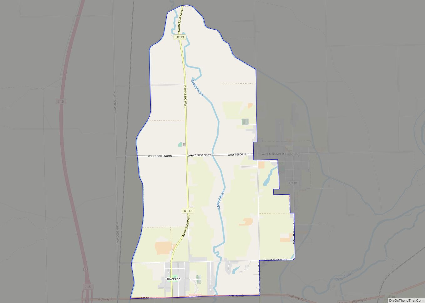
Riverside is a census-designated place (CDP) in Box Elder County, Utah, United States. The population was 760 at the 2010 census. Riverside CDP overview: Name: Riverside CDP LSAD Code: 57 LSAD Description: CDP (suffix) State: Utah County: Box Elder County Founded: 1894 Elevation: 4,363 ft (1,330 m) Total Area: 6.7 sq mi (17.4 km²) Land Area: 6.7 sq mi (17.4 km²) Water Area: ... Read more
Map of Riverside CDP, Utah
Map of Riverdale city, Utah
Riverdale is a city in southern Weber County, Utah, United States. The population was 8,426 at the 2010 census. It is part of the Ogden–Clearfield, Utah Metropolitan Statistical Area. Riverdale city overview: Name: Riverdale city LSAD Code: 25 LSAD Description: city (suffix) State: Utah County: Weber County Incorporated: March 4, 1946 Elevation: 4,370 ft (1,332 m) Total ... Read more
Map of Riverdale city, Utah
Map of River Heights city
River Heights is a city in Cache County, Utah, United States. The population was 1,734 at the 2010 census. It is included in the Logan, Utah–Idaho (partial) Metropolitan Statistical Area. River Heights city overview: Name: River Heights city LSAD Code: 25 LSAD Description: city (suffix) State: Utah County: Cache County Incorporated: October 31, 1934 Elevation: ... Read more
Map of River Heights city
Map of Richmond city, Utah
Richmond is a city in Cache County, Utah, United States. The population was 2,733 at the 2020 census. It is included in the Logan metropolitan area. Richmond city overview: Name: Richmond city LSAD Code: 25 LSAD Description: city (suffix) State: Utah County: Cache County Incorporated: 1868 Elevation: 4,610 ft (1,405 m) Total Area: 3.5 sq mi (9.06 km²) Land Area: ... Read more
Map of Richmond city, Utah
Map of Richfield city, Utah
Richfield is a city in and the county seat of Sevier County, Utah, United States, and is the largest city in southern-central Utah. Richfield city overview: Name: Richfield city LSAD Code: 25 LSAD Description: city (suffix) State: Utah County: Sevier County Elevation: 5,354 ft (1,632 m) Total Area: 5.93 sq mi (15.36 km²) Land Area: 5.93 sq mi (15.36 km²) Water Area: 0.00 sq mi ... Read more
Map of Richfield city, Utah
Map of Redmond town, Utah
Redmond is a town in Sevier County, Utah, United States. The population was 730 at the 2010 census. Redmond was first settled in 1876, and named for red mounds to the west of the town. Redmond town overview: Name: Redmond town LSAD Code: 43 LSAD Description: town (suffix) State: Utah County: Sevier County Elevation: 5,105 ft ... Read more
Map of Redmond town, Utah
Map of Scipio town, Utah
Scipio is a town on the eastern edge of Millard County, Utah, United States. The population was 290 at the 2000 census. Scipio town overview: Name: Scipio town LSAD Code: 43 LSAD Description: town (suffix) State: Utah County: Millard County Elevation: 5,315 ft (1,620 m) Total Area: 1.04 sq mi (2.70 km²) Land Area: 1.04 sq mi (2.70 km²) Water Area: 0.00 sq mi (0.00 km²) ... Read more
Map of Scipio town, Utah
Map of Saratoga Springs city, Utah
Saratoga Springs is a city in Utah County, Utah, United States. The elevation is 4,505 feet. It is part of the Provo–Orem, Utah Metropolitan Statistical Area. The city is a relatively new development along the northwestern shores of Utah Lake. It was incorporated on December 31, 1997 and has been growing rapidly since then. The ... Read more
Map of Saratoga Springs city, Utah
Map of Santa Clara city, Utah
Santa Clara is a city in Washington County, Utah, United States and is a part of the St. George Metropolitan Area. The population was 7,553 at the 2020 census, up from 6,003 at the 2010 census, and 4,630 at the 2000 census. The city is a western suburb of St. George. Santa Clara city overview: ... Read more
Map of Santa Clara city, Utah
Map of Sandy city, Utah
Sandy is a city in the Salt Lake City metropolitan area, located in Salt Lake County, Utah, United States. The population of Sandy was 87,461 at the 2010 census, making it the sixth-largest city in Utah. The population is currently estimated to be about 96,380 according to the July 1, 2019 United States Census estimates. ... Read more
Map of Sandy city, Utah
Map of Samak CDP
Samak is a census-designated place (CDP) in southwestern Summit County, Utah, United States. The population was 287 at the 2010 census. The name is simply the reversal of the name of the nearby city of Kamas. Samak CDP overview: Name: Samak CDP LSAD Code: 57 LSAD Description: CDP (suffix) State: Utah County: Summit County Elevation: ... Read more
Map of Samak CDP
Map of Salina city, Utah
Salina (/səˈlaɪnə/ sə-LY-nə) is a city in Sevier County, Utah, United States. The population was 2,660 at the 2020 census. Salina city overview: Name: Salina city LSAD Code: 25 LSAD Description: city (suffix) State: Utah County: Sevier County Elevation: 5,161 ft (1,573 m) Total Area: 5.83 sq mi (15.10 km²) Land Area: 5.83 sq mi (15.10 km²) Water Area: 0.00 sq mi (0.00 km²) Total Population: ... Read more
Map of Salina city, Utah