Map of Roy city, Utah
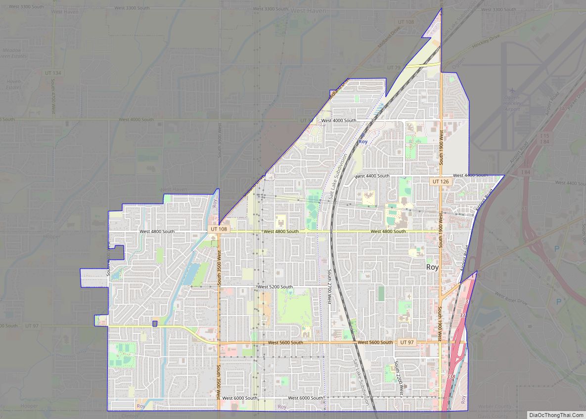
Roy is a city in Weber County, Utah, United States, located on the west side of Interstate 15. The population estimate in 2019 was 39,613, an increase of 5.8% from 36,884 at the 2010 Census. It is part of the Ogden−Clearfield, Utah Metropolitan Statistical Area, and is considered a suburb of nearby Ogden, although some ... Read more
Map of Roy city, Utah
Map of Scipio town, Utah
Scipio is a town on the eastern edge of Millard County, Utah, United States. The population was 290 at the 2000 census. Scipio town overview: Name: Scipio town LSAD Code: 43 LSAD Description: town (suffix) State: Utah County: Millard County Elevation: 5,315 ft (1,620 m) Total Area: 1.04 sq mi (2.70 km²) Land Area: 1.04 sq mi (2.70 km²) Water Area: 0.00 sq mi (0.00 km²) ... Read more
Map of Scipio town, Utah
Map of Saratoga Springs city, Utah
Saratoga Springs is a city in Utah County, Utah, United States. The elevation is 4,505 feet. It is part of the Provo–Orem, Utah Metropolitan Statistical Area. The city is a relatively new development along the northwestern shores of Utah Lake. It was incorporated on December 31, 1997 and has been growing rapidly since then. The ... Read more
Map of Saratoga Springs city, Utah
Map of South Weber city
South Weber (/ˈwiːbər/ WEE-bər) is a city on the northeastern edge of Davis County, Utah, United States. It is part of the Ogden–Clearfield, Utah Metropolitan Statistical Area. The population was 6,051 at the 2010 census, with an estimated population of 7,518 in 2018. South Weber city overview: Name: South Weber city LSAD Code: 25 LSAD ... Read more
Map of South Weber city
Map of South Salt Lake city
South Salt Lake is a city in Salt Lake County, Utah, United States and is part of the Salt Lake City Metropolitan Statistical Area. The population was 23,617 at the 2010 census. South Salt Lake city overview: Name: South Salt Lake city LSAD Code: 25 LSAD Description: city (suffix) State: Utah County: Salt Lake County ... Read more
Map of South Salt Lake city
Map of South Ogden city
South Ogden is a city in Weber County, Utah, United States with 17,199 residents. The population was 16,532 at the 2010 census. It is part of the Ogden–Clearfield, Utah Metropolitan Statistical Area. The current mayor is Russell L. Porter. South Ogden city overview: Name: South Ogden city LSAD Code: 25 LSAD Description: city (suffix) State: ... Read more
Map of South Ogden city
Map of South Jordan city
South Jordan is a city in south central Salt Lake County, Utah, United States, 18 miles (29 km) south of Salt Lake City. Part of the Salt Lake City metropolitan area, the city lies in the Salt Lake Valley along the banks of the Jordan River between the 10,000-foot (3,000 m) Oquirrh Mountains and the 11,000-foot (3,400 m) ... Read more
Map of South Jordan city
Map of Snyderville CDP
Snyderville is a census-designated place (CDP) near the southwestern edge of Summit County, Utah, United States. Prior to the 2010 Census, the area was designated as South Snyderville Basin CDP. The population was 3,636 at the 2000 census. Snyderville CDP overview: Name: Snyderville CDP LSAD Code: 57 LSAD Description: CDP (suffix) State: Utah County: Summit ... Read more
Map of Snyderville CDP
Map of Snowville town, Utah
Snowville is a town in Box Elder County, Utah, United States. The population was 167 at the 2010 census. Snowville town overview: Name: Snowville town LSAD Code: 43 LSAD Description: town (suffix) State: Utah County: Box Elder County Incorporated: November 6, 1933 Elevation: 4,547 ft (1,386 m) Total Area: 1.55 sq mi (4.02 km²) Land Area: 1.55 sq mi (4.02 km²) Water Area: ... Read more
Map of Snowville town, Utah
Map of Smithfield city, Utah
Smithfield is a city in Cache County, Utah, United States. The population was 9,495 at the 2010 United States Census, with an estimated population of 12,025 in 2019. It is included in the Logan, Utah–Idaho Metropolitan Statistical Area, and is the second largest city in the area after Logan, the county seat. Smithfield is home ... Read more
Map of Smithfield city, Utah
Map of Silver Summit CDP
Silver Summit is a census-designated place (CDP) in Summit County, Utah, United States. Prior to the 2010 Census, the area was designated as North Snyderville Basin CDP. The population was 1,821 at the 2000 census. Silver Summit CDP overview: Name: Silver Summit CDP LSAD Code: 57 LSAD Description: CDP (suffix) State: Utah County: Summit County ... Read more
Map of Silver Summit CDP
Map of Sigurd town
Sigurd is a town in Sevier County, Utah, United States. The population was 429 at the 2010 census. Sigurd town overview: Name: Sigurd town LSAD Code: 43 LSAD Description: town (suffix) State: Utah County: Sevier County Incorporated: 1935 Elevation: 5,226 ft (1,593 m) Total Area: 0.98 sq mi (2.55 km²) Land Area: 0.98 sq mi (2.55 km²) Water Area: 0.00 sq mi (0.00 km²) Total Population: ... Read more
Map of Sigurd town