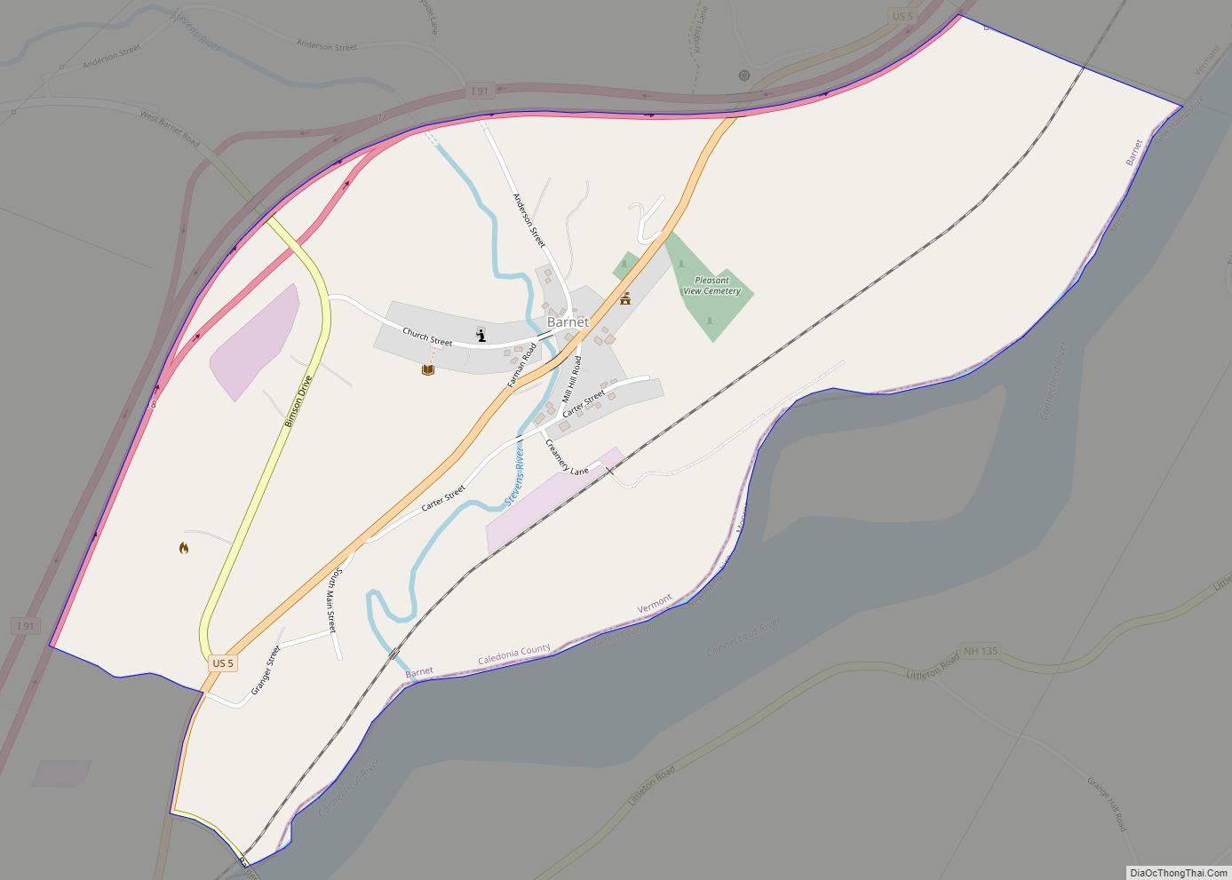
Map of Bethel CDP, Vermont
Bethel is a census-designated place (CDP) that comprises the central village of the town of Bethel, Windsor County, Vermont, United States. As of the 2010 census, the population of the CDP was 569, compared to 2,030 for the entire town of Bethel. Bethel CDP overview: Name: Bethel CDP LSAD Code: 57 LSAD Description: CDP (suffix) ... Read more
Map of Bethel CDP, Vermont
Map of Benson CDP, Vermont
Benson is the primary village and a census-designated place (CDP) in the town of Benson, Rutland County, Vermont, United States. As of the 2020 census, it had a population of 269, out of 974 in the entire town. The CDP is in northwestern Rutland County, at the geographic center of the town. Vermont Route 22A ... Read more
Map of Benson CDP, Vermont
Map of Chester CDP, Vermont
Chester is a census-designated place (CDP) in Windsor County, Vermont, United States. The population was 1,005 at the 2010 census. The CDP is a statistical area encompassing three distinct places: the urbanized center of the town of Chester; a locale known as Chester Depot, which is separated from the town center by the tracks of ... Read more
Map of Chester CDP, Vermont
Map of Chelsea CDP, Vermont
Chelsea is a town in and the shire town (county seat) of Orange County, Vermont, United States. The population was 1,233 at the 2020 census. Chelsea CDP overview: Name: Chelsea CDP LSAD Code: 57 LSAD Description: CDP (suffix) State: Vermont County: Orange County Elevation: 840 ft (256 m) Total Area: 39.9 sq mi (103.4 km²) Land Area: 39.9 sq mi (103.4 km²) Water ... Read more
Map of Chelsea CDP, Vermont
Map of Castleton CDP
Castleton is the primary village and a census-designated place (CDP) in the town of Castleton, Rutland County, Vermont, United States. As of the 2020 census, it had a population of 1,337, out of 4,458 in the entire town. A large portion of the village is part of the Castleton Village Historic District, listed on the ... Read more
Map of Castleton CDP
Map of Canaan CDP, Vermont
Canaan is a census-designated place comprising the main settlement in the town of Canaan, Essex County, Vermont, United States. As of the 2010 census, it had a population of 392, out of a total town population of 972. The Canaan CDP is in the northeast part of the town of Canaan and is bordered by ... Read more
Map of Canaan CDP, Vermont
Map of Brattleboro CDP
Brattleboro is a census-designated place (CDP) corresponding to the densely populated core of the town of Brattleboro in Windham County, Vermont, United States. The population was 8,289 at the 2000 census. Brattleboro CDP overview: Name: Brattleboro CDP LSAD Code: 57 LSAD Description: CDP (suffix) State: Vermont County: Windham County Elevation: 223 ft (68 m) Total Area: 10.0 sq mi ... Read more
Map of Brattleboro CDP
Map of Brandon CDP, Vermont
Brandon is an unincorporated village and census-designated place (CDP) in the town of Brandon, Rutland County, Vermont, United States. As of the 2020 census, the population was 1,727. Most of the village is listed on the National Register of Historic Places as the Brandon Village Historic District. Brandon CDP overview: Name: Brandon CDP LSAD Code: ... Read more
Map of Brandon CDP, Vermont
Map of Danville CDP, Vermont
Danville is the primary village and a census-designated place (CDP) in the town of Danville, Caledonia County, Vermont, United States. As of the 2020 census, the CDP had a population of 385, out of 2,335 in the entire town of Danville. The village is in west-central Caledonia County, south of the center of the town ... Read more
Map of Danville CDP, Vermont
Map of Concord CDP, Vermont
Concord is a census-designated place comprising the main settlement in the town of Concord, Essex County, Vermont, United States. As of the 2010 census, it had a population of 271, out of a total town population of 1,235. The Concord CDP is in the western part of the town of Concord, along the Moose River, ... Read more
Map of Concord CDP, Vermont
Map of East Middlebury CDP
East Middlebury is a census-designated place in the town of Middlebury, Addison County, Vermont, United States. Its population was 425 as of the 2010 census. East Middlebury first came to the attention of settlers from English America after the French and Indian War. The charter that created Middlebury dates from 1761 and the earliest settlement ... Read more
Map of East Middlebury CDP
Map of East Burke CDP
East Burke is a census-designated place in the town of Burke in Caledonia County, Vermont, United States. Its population was 132 as of the 2010 census. It is home to Burke Mountain and Burke Mountain Academy. East Burke CDP overview: Name: East Burke CDP LSAD Code: 57 LSAD Description: CDP (suffix) State: Vermont County: Caledonia ... Read more
Map of East Burke CDP