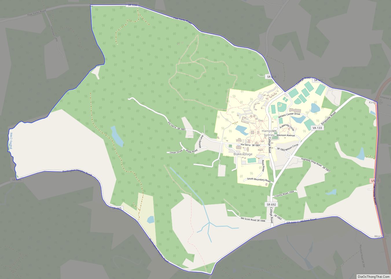
Map of East Highland Park CDP

Map of East Highland Park CDP

East Highland Park is a census-designated place (CDP) in Henrico County, Virginia, in the United States. The population was 15,131 at the 2020 census. East Highland Park CDP overview: Name: East Highland Park CDP LSAD Code: 57 LSAD Description: CDP (suffix) State: Virginia County: Henrico County Elevation: 200 ft (61 m) Total Area: 9.0 sq mi (23.3 km²) Land Area: … Read more

Map of Dunn Loring CDP

Map of Dunn Loring CDP

Dunn Loring is a census-designated place (CDP) in Fairfax County, Virginia, United States. The population was 8,803 at the 2010 census. The area borders Merrifield, Vienna, and Tysons.Dunn Loring is in the Metropolitan Area and is a suburban area next to DC. Many stars and celebrities have visited this city. Dunn Loring CDP overview: Name: … Read more

Map of Dungannon town

Map of Dungannon town

Dungannon is a town in Scott County, Virginia, United States. The population was 332 at the 2010 census. It was named after the town of Dungannon in County Tyrone, Northern Ireland. Dungannon is part of the Kingsport–Bristol (TN)–Bristol (VA) Metropolitan Statistical Area, which is a component of the Johnson City–Kingsport–Bristol, TN-VA Combined Statistical Area – … Read more

Map of Dumfries town

Map of Dumfries town

Dumfries, officially the Town of Dumfries, is a town in Prince William County, Virginia. The population was 4,961 at the 2010 United States Census. Dumfries town overview: Name: Dumfries town LSAD Code: 43 LSAD Description: town (suffix) State: Virginia County: Prince William County Founded: 1749 Elevation: 36 ft (11 m) Total Area: 1.55 sq mi (4.02 km²) Land Area: 1.53 sq mi … Read more

Map of Dumbarton CDP

Map of Dumbarton CDP

Dumbarton is a census-designated place (CDP) in Henrico County, Virginia, United States. The population was 7,879 at the 2010 census. Dumbarton CDP overview: Name: Dumbarton CDP LSAD Code: 57 LSAD Description: CDP (suffix) State: Virginia County: Henrico County Elevation: 200 ft (61 m) Total Area: 1.9 sq mi (4.9 km²) Land Area: 1.9 sq mi (4.9 km²) Water Area: 0.0 sq mi (0.0 km²) Total Population: … Read more

Map of Dulles Town Center CDP

Map of Dulles Town Center CDP

Dulles Town Center is a census-designated place (CDP) in Loudoun County, Virginia, United States. It is located about 7 miles (11 km) north of Washington Dulles International Airport. The CDP is the location of the Dulles Town Center shopping mall, for which it is named. The United States Postal Service considers Dulles Town Center to be … Read more

Map of Fair Oaks CDP, Virginia

Map of Fair Oaks CDP, Virginia

Fair Oaks is a census-designated place in Fairfax County, Virginia, United States. The population as of the 2010 census was 30,223. It encompasses a large area west of the city of Fairfax, centered on Fair Oaks Mall. Suburban neighborhoods and office parks occupy most of Fair Oaks, largely developed since the 1980s. The Fair Oaks … Read more

Map of Fair Lakes CDP

Map of Fair Lakes CDP

Fair Lakes is a census-designated place (CDP) and business park located west of Fairfax in Fairfax County, Virginia, United States. Fair Lakes had a population of 7,942 in 2010. Fair Lakes CDP overview: Name: Fair Lakes CDP LSAD Code: 57 LSAD Description: CDP (suffix) State: Virginia County: Fairfax County Elevation: 400 ft (100 m) Total Area: 2.42 sq mi … Read more

Map of Exmore town

Map of Exmore town

Exmore is the largest town in Northampton County on the Eastern Shore of the U.S. state of Virginia. The population was 1,460 at the 2010 census. A popular story is that Exmore received its name because it is the tenth railroad station south of the Delaware state line, so there were “X more” stations to … Read more

Map of Ewing CDP, Virginia

Map of Ewing CDP, Virginia

Ewing is an unincorporated community and census-designated place (CDP) in Lee County, Virginia. The population was 439 at the 2010 U.S. Census. Ewing is one of the westernmost settlements in the Commonwealth of Virginia, before reaching the Cumberland Gap and the borders with Kentucky and Tennessee. The Ewing post office was established in 1891. Ewing … Read more

Map of Ettrick CDP

Map of Ettrick CDP, Virginia

Ettrick is a census-designated place (CDP) in Chesterfield County, Virginia, United States. Per the 2020 census, the population was 7,241. The town is home to Virginia State University and the Petersburg Amtrak train station. Most of Ettrick has a Petersburg mailing address, ZIP code 23803, although the community is not part of the city of … Read more

Map of Esmont CDP

Map of Esmont CDP

Esmont is a census-designated place (CDP) in Albemarle County, Virginia, United States. The population as of the 2020 Census was 491. Esmont, Guthrie Hall, and Mountain Grove are listed the National Register of Historic Places. Esmont CDP overview: Name: Esmont CDP LSAD Code: 57 LSAD Description: CDP (suffix) State: Virginia County: Albemarle County FIPS code: … Read more