Map of Bailey's Crossroads CDP

Map of Bailey’s Crossroads CDP

Bailey’s Crossroads is a census-designated place (CDP) in Fairfax County, Virginia, United States. The population was 24,749 at the 2020 census. Bailey’s Crossroads lies at the crossroads of State Route 7 (Leesburg Pike) and State Route 244 (Columbia Pike). Bailey’s Crossroads CDP overview: Name: Bailey’s Crossroads CDP LSAD Code: 57 LSAD Description: CDP (suffix) State: … Read more

Map of Augusta Springs CDP

Map of Augusta Springs CDP

Augusta Springs, Virginia is a census-designated place (CDP) in Augusta County, Virginia, United States. The population at the 2010 Census was 257. Augusta Springs CDP overview: Name: Augusta Springs CDP LSAD Code: 57 LSAD Description: CDP (suffix) State: Virginia County: Augusta County FIPS code: 5103608 GNISfeature ID: 2584801 Online Interactive Map Augusta Springs online map. … Read more

Map of Atlantic CDP, Virginia

Map of Atlantic CDP, Virginia

Atlantic is a census-designated place (CDP) in Accomack County, Virginia. It was first listed as a CDP in 2010. Per the 2020 census, the population was 808. Atlantic CDP overview: Name: Atlantic CDP LSAD Code: 57 LSAD Description: CDP (suffix) State: Virginia County: Accomack County Elevation: 11 m (36 ft) Total Area: 15.9 km² (6.13 sq mi) Land Area: 15.3 km² … Read more

Map of Atkins CDP, Virginia

Map of Atkins CDP, Virginia

Atkins is a census-designated place (CDP) in Smyth County, Virginia, United States. The population was 1,143 at the 2010 census. Atkins CDP overview: Name: Atkins CDP LSAD Code: 57 LSAD Description: CDP (suffix) State: Virginia County: Smyth County Elevation: 2,297 ft (700 m) Total Area: 5.4 sq mi (14.0 km²) Land Area: 5.4 sq mi (14.0 km²) Water Area: 0.0 sq mi (0.0 km²) Total Population: … Read more

Map of Ashland town, Virginia

Map of Ashland town, Virginia

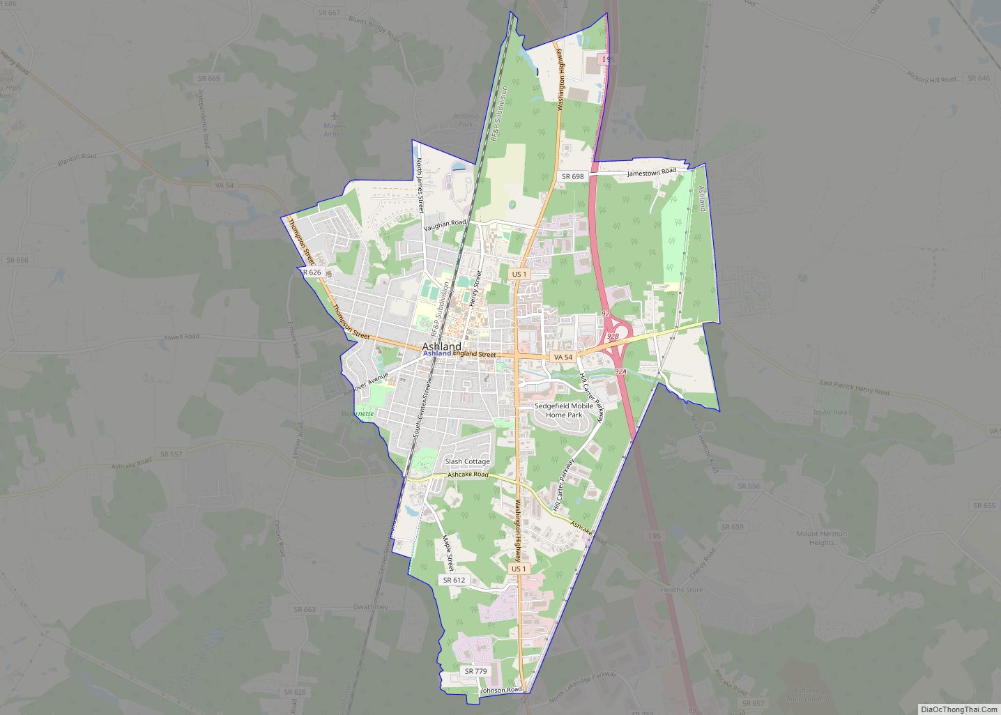
Ashland is a town in Hanover County, Virginia, United States, located 16 miles (26 km) north of Richmond along Interstate 95 and U.S. Route 1. As of the 2020 census it had a population of 7,565, up from 7,225 at the 2010 census. Ashland is named after the Lexington, Kentucky estate of Hanover County native and … Read more

Map of Ashburn CDP, Virginia

Map of Ashburn CDP, Virginia

Ashburn is a census-designated place (CDP) in Loudoun County, Virginia, United States. At the 2010 United States Census, its population was 43,511, up from 3,393 twenty years earlier. It is 30 miles (48 km) northwest of Washington, D.C., and part of the Washington metropolitan area. Ashburn is a major hub for Internet traffic, due to its … Read more

Map of Arrington CDP

Map of Arrington CDP

Arrington CDP overview: Name: Arrington CDP LSAD Code: 57 LSAD Description: CDP (suffix) State: Virginia County: Nelson County FIPS code: 5103208 Online Interactive Map Arrington online map. Source: Basemap layers from Google Map, Open Street Map (OSM), Arcgisonline, Wmflabs. Boundary Data from Database of Global Administrative Areas. Arrington location map. Where is Arrington CDP? Arrington … Read more

Map of Arlington CDP, Virginia

Map of Arlington CDP, Virginia

Arlington CDP overview: Name: Arlington CDP LSAD Code: 57 LSAD Description: CDP (suffix) State: Virginia County: Arlington County FIPS code: 5103000 Online Interactive Map Arlington online map. Source: Basemap layers from Google Map, Open Street Map (OSM), Arcgisonline, Wmflabs. Boundary Data from Database of Global Administrative Areas. Arlington location map. Where is Arlington CDP? Arlington … Read more

Map of Arcola CDP, Virginia

Map of Arcola CDP, Virginia

Arcola is a census-designated place in Loudoun County, Virginia, United States. The population as of the 2010 United States Census was 233. Arcola CDP overview: Name: Arcola CDP LSAD Code: 57 LSAD Description: CDP (suffix) State: Virginia County: Loudoun County Elevation: 285 ft (87 m) Total Area: 2.31 sq mi (5.98 km²) Land Area: 2.29 sq mi (5.92 km²) Water Area: 0.02 sq mi (0.06 km²) … Read more

Map of Aquia Harbour CDP

Map of Aquia Harbour CDP

Aquia Harbour is a census-designated place (CDP) in Stafford County, Virginia, United States, 13 miles (21 km) north of Fredericksburg. The population was 6,727 at the 2010 census. Aquia Church, erected in 1757 and now a National Historic Landmark, is located west of the community. Aquia Harbour CDP overview: Name: Aquia Harbour CDP LSAD Code: 57 … Read more

Map of Bealeton CDP

Map of Bealeton CDP

Bealeton CDP overview: Name: Bealeton CDP LSAD Code: 57 LSAD Description: CDP (suffix) State: Virginia County: Fauquier County FIPS code: 5105336 Online Interactive Map Bealeton online map. Source: Basemap layers from Google Map, Open Street Map (OSM), Arcgisonline, Wmflabs. Boundary Data from Database of Global Administrative Areas. Bealeton location map. Where is Bealeton CDP? Bealeton … Read more

Map of Bayside CDP, Virginia

Map of Bayside CDP, Virginia

Bayside is a census-designated place (CDP) in Accomack County, Virginia, United States. It was first listed as a CDP in 2010. Per the 2020 census, the population was 107. Bayside CDP overview: Name: Bayside CDP LSAD Code: 57 LSAD Description: CDP (suffix) State: Virginia County: Accomack County Elevation: 3 m (10 ft) Total Area: 107 FIPS code: … Read more