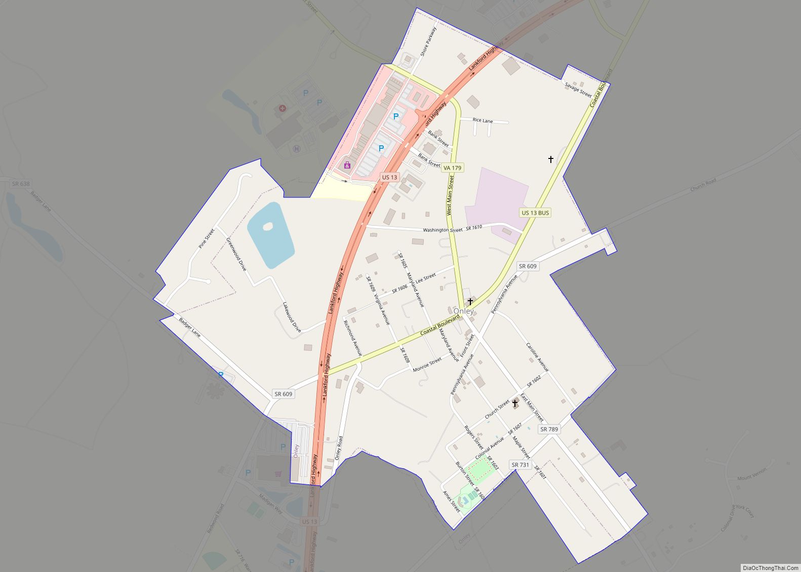
Map of Lee Mont CDP

Map of Lee Mont CDP

Lee Mont is a census-designated place (CDP) in Accomack County, Virginia, United States. Per the 2020 census, the population was 102. Lee Mont CDP overview: Name: Lee Mont CDP LSAD Code: 57 LSAD Description: CDP (suffix) State: Virginia County: Accomack County Elevation: 4 m (13 ft) Total Area: 102 FIPS code: 5144952 GNISfeature ID: 2584865 Online Interactive … Read more

Map of Lebanon town, Virginia

Map of Lebanon town, Virginia

Lebanon is a town in Russell County, Virginia, United States. The population was 3,424 at the 2010 census. It is the county seat of Russell County. Lebanon town overview: Name: Lebanon town LSAD Code: 43 LSAD Description: town (suffix) State: Virginia County: Russell County Elevation: 2,060 ft (628 m) Total Area: 4.83 sq mi (12.52 km²) Land Area: 4.82 sq mi (12.47 km²) … Read more

Map of Laymantown CDP

Map of Laymantown CDP

Laymantown is a census-designated place (CDP) in southern Botetourt County, Virginia, United States. The population was 1,867 at the 2020 census. The community is located along State Route 658 (Laymantown Road). It is part of the Roanoke Metropolitan Statistical Area. Laymantown CDP overview: Name: Laymantown CDP LSAD Code: 57 LSAD Description: CDP (suffix) State: Virginia … Read more

Map of Lawrenceville town, Virginia

Map of Lawrenceville town, Virginia

Lawrenceville is a town in Brunswick County, Virginia, United States. Per the 2020 census, the population was 1,014. Located by the Meherrin River, it is the county seat of Brunswick County. In colonial times, Lieutenant Governor Alexander Spotswood had a stockade built nearby, called Fort Christanna, where converted Native American allies were housed and educated. … Read more

Map of Low Moor CDP, Virginia

Map of Low Moor CDP, Virginia

Low Moor is a census-designated place (CDP) in Alleghany County, Virginia. The population was 258 at the 2010 census. Low Moor CDP overview: Name: Low Moor CDP LSAD Code: 57 LSAD Description: CDP (suffix) State: Virginia County: Alleghany County Elevation: 1,122 ft (342 m) Total Area: 0.8 sq mi (2.2 km²) Land Area: 0.8 sq mi (2.1 km²) Water Area: 0.0 sq mi (0.0 km²) Total … Read more

Map of Lovingston CDP

Map of Lovingston CDP

Lovingston CDP overview: Name: Lovingston CDP LSAD Code: 57 LSAD Description: CDP (suffix) State: Virginia County: Nelson County FIPS code: 5147224 Online Interactive Map Lovingston online map. Source: Basemap layers from Google Map, Open Street Map (OSM), Arcgisonline, Wmflabs. Boundary Data from Database of Global Administrative Areas. Lovingston location map. Where is Lovingston CDP? Lovingston … Read more

Map of Lovettsville town

Map of Lovettsville town

Lovettsville is a town in Loudoun County, located near the very northern tip of the Commonwealth of Virginia, United States. Settled primarily by German immigrants, the town was originally established in 1836. The population was 1,613 at the 2010 census and an estimated 2,198 in 2019. Lovettsville town overview: Name: Lovettsville town LSAD Code: 43 … Read more

Map of Louisa town, Virginia

Map of Louisa town, Virginia

Louisa (originally named Louisa Court House) is a town in Louisa County, Virginia, United States. The population was 1,555 at the 2010 census. It is the county seat of Louisa County. Louisa town overview: Name: Louisa town LSAD Code: 43 LSAD Description: town (suffix) State: Virginia County: Louisa County Founded: 1873 Elevation: 466 ft (142 m) Total … Read more

Map of Loudoun Valley Estates CDP

Map of Loudoun Valley Estates CDP

Loudoun Valley Estates is a census-designated place (CDP) in Loudoun County, Virginia, United States. The population as of the 2010 United States Census was 3,656. It is a Toll Brothers community located near the planned Ashburn Metro station complex and Moorefield Station town center in the southern part of Ashburn, Virginia. Loudoun Valley Estates is … Read more

Map of Lorton CDP, Virginia

Map of Lorton CDP, Virginia

Lorton is a census-designated place (CDP) in Fairfax County, Virginia, United States. The population was 20,072 as of the 2020 census. Lorton CDP overview: Name: Lorton CDP LSAD Code: 57 LSAD Description: CDP (suffix) State: Virginia County: Fairfax County Elevation: 144 ft (44 m) Total Area: 5.4 sq mi (13.9 km²) Land Area: 5.3 sq mi (13.7 km²) Water Area: 0.08 sq mi (0.2 km²) Total … Read more

Map of Long Branch CDP, Virginia

Map of Long Branch CDP, Virginia

Long Branch is a census-designated place in Fairfax County, Virginia, bordering the city of Fairfax. The population as of the 2010 census was 7,593. Long Branch CDP overview: Name: Long Branch CDP LSAD Code: 57 LSAD Description: CDP (suffix) State: Virginia County: Fairfax County Elevation: 360 ft (110 m) Total Area: 2.48 sq mi (6.42 km²) Land Area: 2.46 sq mi (6.38 km²) … Read more

Map of Loch Lomond CDP

Map of Loch Lomond CDP

Loch Lomond is a census-designated place (CDP) in Prince William County, Virginia, United States. The population was 3,701 at the 2010 census. It is named after a loch in northern Scotland, Loch Lomond. Loch Lomond CDP overview: Name: Loch Lomond CDP LSAD Code: 57 LSAD Description: CDP (suffix) State: Virginia County: Prince William County Elevation: … Read more