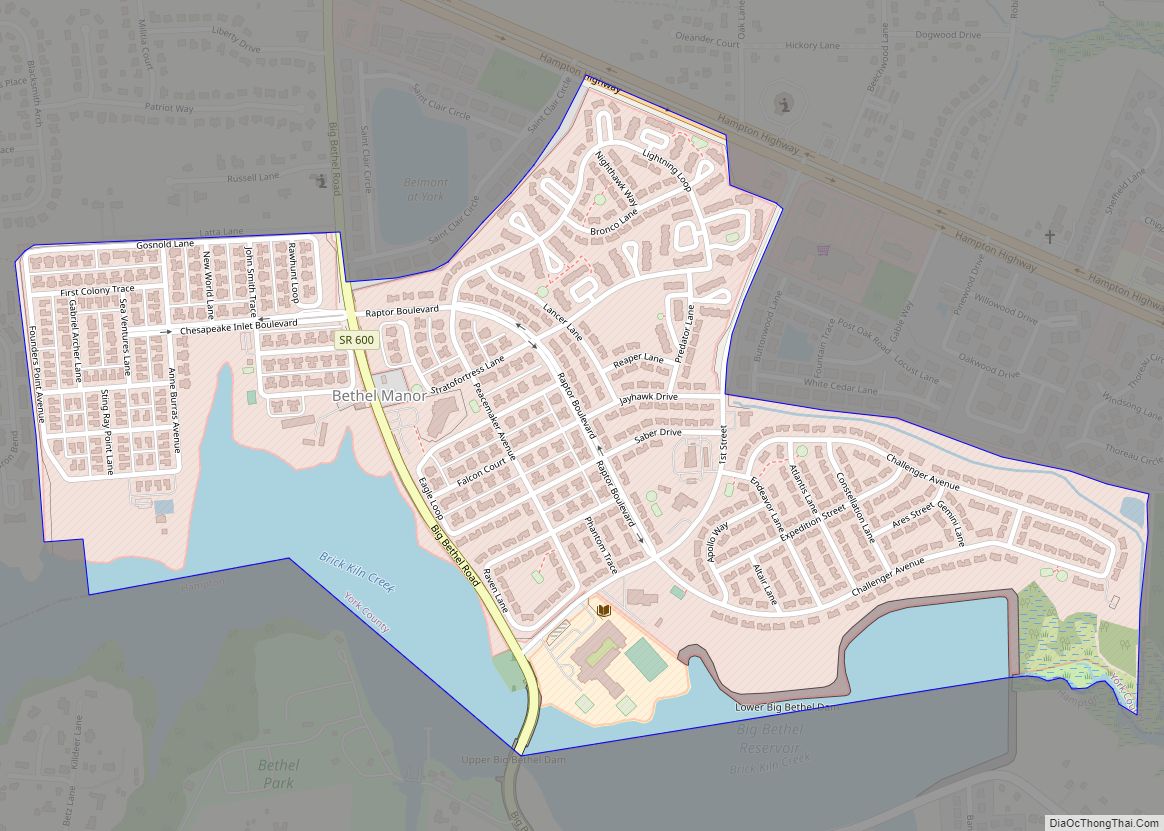
Map of Belmont Estates CDP

Map of Belmont Estates CDP

Belmont Estates is a census-designated place in Rockingham County, Virginia. The population as of the 2010 Census was 1,263. It is a suburban bedroom community just to the west of Harrisonburg. Belmont Estates CDP overview: Name: Belmont Estates CDP LSAD Code: 57 LSAD Description: CDP (suffix) State: Virginia County: Rockingham County Total Area: 1,263 ZIP … Read more

Map of Bellwood CDP, Virginia

Map of Bellwood CDP, Virginia

Bellwood is a census-designated place (CDP) in Chesterfield County, Virginia, United States. The population was 6,352 at the 2010 census. The community takes its name from Bellwood, one of the James River Plantations. Bellwood CDP overview: Name: Bellwood CDP LSAD Code: 57 LSAD Description: CDP (suffix) State: Virginia County: Chesterfield County Elevation: 95 ft (29 m) Total … Read more

Map of Belle Haven CDP

Map of Belle Haven CDP

Belle Haven is a census-designated place (CDP) in Fairfax County, Virginia, United States. Nearby CDPs are Huntington (northwest), Groveton (southwest) and Fort Hunt (south). The population of Belle Haven was 6,518 at the 2010 census. The CDP is located just south of Old Town Alexandria and bounded on the west by Richmond Highway (U.S. 1) … Read more

Map of Bealeton CDP

Map of Bealeton CDP

Bealeton CDP overview: Name: Bealeton CDP LSAD Code: 57 LSAD Description: CDP (suffix) State: Virginia County: Fauquier County FIPS code: 5105336 Online Interactive Map Bealeton online map. Source: Basemap layers from Google Map, Open Street Map (OSM), Arcgisonline, Wmflabs. Boundary Data from Database of Global Administrative Areas. Bealeton location map. Where is Bealeton CDP? Bealeton … Read more

Map of Bayside CDP, Virginia

Map of Bayside CDP, Virginia

Bayside is a census-designated place (CDP) in Accomack County, Virginia, United States. It was first listed as a CDP in 2010. Per the 2020 census, the population was 107. Bayside CDP overview: Name: Bayside CDP LSAD Code: 57 LSAD Description: CDP (suffix) State: Virginia County: Accomack County Elevation: 3 m (10 ft) Total Area: 107 FIPS code: … Read more

Map of Basye CDP

Map of Basye CDP

Basye is a census-designated place (CDP) in Shenandoah County, Virginia, United States. The population was 1,374 at the 2020 census. As of the 2000 census, the CDP was known as Basye-Bryce Mountain. Basye CDP overview: Name: Basye CDP LSAD Code: 57 LSAD Description: CDP (suffix) State: Virginia County: Shenandoah County Total Area: 8.8 sq mi (22.8 km²) Land … Read more

Map of Bassett CDP, Virginia

Map of Bassett CDP, Virginia

Bassett CDP overview: Name: Bassett CDP LSAD Code: 57 LSAD Description: CDP (suffix) State: Virginia County: Henry County FIPS code: 5104872 Online Interactive Map Bassett online map. Source: Basemap layers from Google Map, Open Street Map (OSM), Arcgisonline, Wmflabs. Boundary Data from Database of Global Administrative Areas. Bassett location map. Where is Bassett CDP? Bassett … Read more

Map of Baskerville CDP

Map of Baskerville CDP

Baskerville is a census-designated place in Mecklenburg County, Virginia. The population as of the 2010 Census was 128. The state’s Baskerville Correctional Center is nearby, but not within the CDP. Elm Hill and Eureka are listed on the National Register of Historic Places. Baskerville CDP overview: Name: Baskerville CDP LSAD Code: 57 LSAD Description: CDP … Read more

Map of Benns Church CDP

Map of Benns Church CDP

Benns Church is a census-designated place (CDP) in Isle of Wight County, Virginia, United States. It is located at the junction of U.S. Route 258 and State Routes 10 and 32, southeast of Smithfield. The population as of the 2010 census was 872. The community is named for Benn’s United Methodist Church, which lies at … Read more

Map of Belview CDP, Virginia

Map of Belview CDP, Virginia

Belview is a census-designated place in Montgomery County, Virginia, United States, just southeast of Radford Army Ammunition Plant. The population as of the 2010 Census was 891. Belview CDP overview: Name: Belview CDP LSAD Code: 57 LSAD Description: CDP (suffix) State: Virginia County: Montgomery County ZIP code: 24141 FIPS code: 5106512 GNISfeature ID: 2584807 Online … Read more

Map of Blairs CDP

Map of Blairs CDP

Blairs is a census-designated place (CDP) in Pittsylvania County, Virginia, United States. The population as of the 2010 Census was 916. Chatham-Blairs is also the name of a political district in south-central Pittsylvania County, Virginia. Blairs CDP overview: Name: Blairs CDP LSAD Code: 57 LSAD Description: CDP (suffix) State: Virginia County: Pittsylvania County FIPS code: … Read more

Map of Blackstone town

Map of Blackstone town

Blackstone, formerly named Blacks and Whites, and then Bellefonte, is a town in Nottoway County in the U.S. state of Virginia. The population was 3,621 at the 2010 census. Blackstone town overview: Name: Blackstone town LSAD Code: 43 LSAD Description: town (suffix) State: Virginia County: Nottoway County Elevation: 453 ft (138 m) Total Area: 4.51 sq mi (11.69 km²) Land … Read more