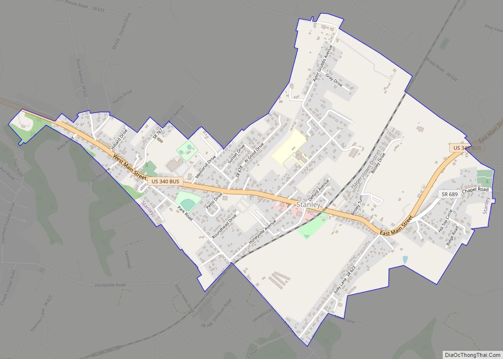
Map of Sterling CDP, Virginia
Sterling, Virginia, refers most specifically to a census-designated place (CDP) in Loudoun County, Virginia, United States. The population of the CDP as of the 2010 United States Census was 27,822. The CDP boundaries are confined to a relatively small area between Virginia State Route 28 on the west and Virginia State Route 7 on the ... Read more
Map of Sterling CDP, Virginia
Map of Stephens City town
Stephens City (/ˈstiːvənz/ STEE-vənz) is an incorporated town in the southern part of Frederick County, Virginia, United States, with a population of 1,829 at the time of the 2010 census. and an estimated population in 2018 of 2,041. Founded by Peter Stephens in the 1730s, the colonial town was chartered and named for Lewis Stephens (Peter’s ... Read more
Map of Stephens City town
Map of Stanleytown CDP
Stanleytown is a census-designated place (CDP) in Henry County, Virginia, United States. The population was 1,422 at the 2010 census. It is part of the Martinsville Micropolitan Statistical Area. Stanleytown CDP overview: Name: Stanleytown CDP LSAD Code: 57 LSAD Description: CDP (suffix) State: Virginia County: Henry County Elevation: 781 ft (238 m) Total Area: 2.7 sq mi (7.0 km²) Land ... Read more
Map of Stanleytown CDP
Map of Tasley CDP
Tasley is a census-designated place (CDP) in Accomack County, Virginia, United States. It was first listed as a CDP in 2010. Per the 2020 census, the population was 222. Tasley CDP overview: Name: Tasley CDP LSAD Code: 57 LSAD Description: CDP (suffix) State: Virginia County: Accomack County Elevation: 39 ft (12 m) Total Area: 222 FIPS code: ... Read more
Map of Tasley CDP
Map of Tappahannock town
Tappahannock is the oldest town in Essex County, Virginia, United States. The population was 2,375 at the 2010 census, up from 2,068 at the 2000 census. Located on the Rappahannock River, Tappahannock is the county seat of Essex County. Its name comes from an Algonquian language word lappihanne (also noted as toppehannock), meaning “Town on ... Read more
Map of Tappahannock town
Map of Tangier town
Tangier is a town in Accomack County, Virginia, United States, on Tangier Island in Chesapeake Bay. The population was 727 at the 2010 census. Since 1850, the island’s landmass has been reduced by 67%. Under the mid-range sea level rise scenario, much of the remaining landmass is expected to be lost in the next 50 ... Read more
Map of Tangier town
Map of Sussex CDP, Virginia
Sussex is a census-designated place (CDP) in and the county seat of Sussex County, Virginia, United States. The population as of the 2020 Census was 181. The Sussex County Courthouse Historic District was listed on the National Register of Historic Places in 1973. Sussex CDP overview: Name: Sussex CDP LSAD Code: 57 LSAD Description: CDP ... Read more
Map of Sussex CDP, Virginia
Map of Surry town
Surry (formerly Cross Roads, McIntosh’s Cross Roads, McIntoshs Cross Roads, Scuffletown, Smithville, Surry Court House, and The Crossroads) is an incorporated town in Surry County, Virginia, United States. The population was 244 at the 2010 census. It is the county seat of Surry County. Its name is derived from the historic county of Surrey in ... Read more
Map of Surry town
Map of Sugarland Run CDP
Sugarland Run is a planned community and census-designated place in Loudoun County, Virginia, United States. The population at the 2010 census was 11,799. In 2020, it was estimated to be 12,956. Sugarland Run is part of the Washington metropolitan area and is 26 miles (42 km) by road northwest of Washington, D.C. Sugarland Run CDP overview: ... Read more
Map of Sugarland Run CDP
Map of Sugar Grove CDP, Virginia
Sugar Grove is a census-designated place (CDP) in Smyth County, Virginia, United States. The population was 758 at the 2010 census. Sugar Grove CDP overview: Name: Sugar Grove CDP LSAD Code: 57 LSAD Description: CDP (suffix) State: Virginia County: Smyth County Elevation: 2,585 ft (788 m) Total Area: 8.4 sq mi (21.7 km²) Land Area: 8.4 sq mi (21.7 km²) Water Area: 0.0 sq mi ... Read more
Map of Sugar Grove CDP, Virginia
Map of Sudley CDP
Sudley is a census-designated place (CDP) in Prince William County, Virginia, United States. As of the 2010 census, Sudley comprises what in the 2000 census were the Sudley and West Gate CDPs. Sudley’s population including West Gate was 16,203 at the 2010 census, and excluding West Gate was 7,719 at the 2000 census. Sudley contains ... Read more
Map of Sudley CDP
Map of Stuarts Draft CDP
Stuarts Draft CDP overview: Name: Stuarts Draft CDP LSAD Code: 57 LSAD Description: CDP (suffix) State: Virginia County: Augusta County FIPS code: 5176272 Online Interactive Map Stuarts Draft online map. Source: Basemap layers from Google Map, Open Street Map (OSM), Arcgisonline, Wmflabs. Boundary Data from Database of Global Administrative Areas. Stuarts Draft location map. Where ... Read more
Map of Stuarts Draft CDP