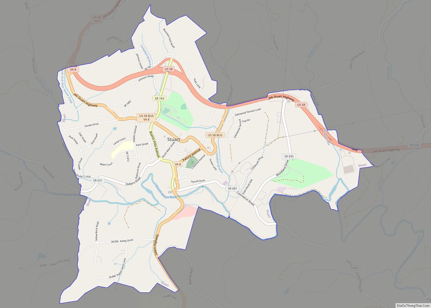
Map of Pimmit Hills CDP

Map of Pimmit Hills CDP

Pimmit Hills is a census-designated place (CDP) in Fairfax County, Virginia, United States. The population was 6,094 at the 2010 census. In practical terms, it is more of a neighborhood within a densely populated urban area than a traditional town. It is found within the triangle made by the intersection of three highways: Interstate 495 … Read more

Map of Phenix town

Map of Phenix town

Phenix is a town in Charlotte County, Virginia, United States. The population was 226 at the 2010 census. Phenix town overview: Name: Phenix town LSAD Code: 43 LSAD Description: town (suffix) State: Virginia County: Charlotte County Elevation: 522 ft (159 m) Total Area: 1.15 sq mi (2.99 km²) Land Area: 1.15 sq mi (2.99 km²) Water Area: 0.00 sq mi (0.00 km²) Total Population: 226 Population … Read more

Map of Pennington Gap town

Map of Pennington Gap town

Pennington Gap is the most populous town in Lee County, Virginia, United States. The population was 1,781 at the 2010 census. The Lee Regional Medical Center was in Pennington Gap until it closed in October 2013, and the United States Penitentiary, Lee is nearby. The Pennington Gap post office was established in 1891. Pennington Gap … Read more

Map of Penhook CDP

Map of Penhook CDP

Penhook CDP overview: Name: Penhook CDP LSAD Code: 57 LSAD Description: CDP (suffix) State: Virginia County: Franklin County FIPS code: 5161464 Online Interactive Map Penhook online map. Source: Basemap layers from Google Map, Open Street Map (OSM), Arcgisonline, Wmflabs. Boundary Data from Database of Global Administrative Areas. Penhook location map. Where is Penhook CDP? Penhook … Read more

Map of Pembroke town, Virginia

Map of Pembroke town, Virginia

Pembroke ( /ˈpɪmbrʊk/ PIM-bruuk) is a town in Giles County, Virginia, United States. The population was 1,128 at the 2010 census. It is part of the Blacksburg–Christiansburg Metropolitan Statistical Area. Pembroke town overview: Name: Pembroke town LSAD Code: 43 LSAD Description: town (suffix) State: Virginia County: Giles County Elevation: 1,654 ft (504 m) Total Area: 1.09 sq mi (2.81 km²) … Read more

Map of Pearisburg town

Map of Pearisburg town

Pearisburg is a town in Giles County, Virginia, and the county seat. The population was 2,786 at the time of the 2010 census. Pearisburg is part of the Blacksburg–Christiansburg Metropolitan Statistical Area. Pearisburg town overview: Name: Pearisburg town LSAD Code: 43 LSAD Description: town (suffix) State: Virginia County: Giles County Elevation: 1,808 ft (551 m) Total Area: … Read more

Map of Quantico town, Virginia

Map of Quantico town, Virginia

Quantico (/ˈkwɒntɪkoʊ/ or /ˈkwɒnɪkoʊ/; formerly Potomac) is a town in Prince William County, Virginia, United States. The population was 480 at the 2010 census. Quantico is approximately 35 miles southwest of Washington, DC, bordered by the Potomac River to the east and the Quantico Creek to the north. The word Quantico is a corruption of … Read more

Map of Quantico Base CDP

Map of Quantico Base CDP

Marine Corps Base Quantico (commonly abbreviated MCB Quantico) is a United States Marine Corps installation located near Triangle, Virginia, covering nearly 55,148 acres (86.169 sq mi) of southern Prince William County, Virginia, northern Stafford County, and southeastern Fauquier County. Used primarily for training purposes, MCB Quantico is known as the “Crossroads of the Marine Corps”. Quantico Station … Read more

Map of Purcellville town

Map of Purcellville town

Purcellville is a town in Loudoun County, Virginia. The population was 8,929 according to the 2020 Census. Purcellville is the major population center for Western Loudoun and the Loudoun Valley. Many of the older structures remaining in Purcellville reflect the Victorian architecture popular during the early twentieth century. Purcellville town overview: Name: Purcellville town LSAD … Read more

Map of Pungoteague CDP

Map of Pungoteague CDP

Pungoteague is a census-designated place (CDP) in Accomack County, Virginia, United States. It was first listed as a CDP in 2010. Per the 2020 census, the population was 346. The name itself is a derivative of the Indian term “Pungotekw,” which means Sand Fly River and is the name used by the earliest inhabitants. In … Read more

Map of Pulaski town, Virginia

Map of Pulaski town, Virginia

Pulaski is a town in Pulaski County, Virginia, United States. The population was 9,086 at the 2010 census. It is the county seat of Pulaski County. Pulaski is part of the Blacksburg–Christiansburg Metropolitan Statistical Area. Pulaski town overview: Name: Pulaski town LSAD Code: 43 LSAD Description: town (suffix) State: Virginia County: Pulaski County Elevation: 1,903 ft … Read more

Map of Prince George CDP

Map of Prince George CDP

Prince George is a census-designated place (CDP) in and the county seat of Prince George County, Virginia, United States. The population as of the 2010 Census was 2,066. It is in the metro area of Richmond, Virginia. The elevation is at 131 feet. The Prince George County Courthouse Historic District was listed on the National … Read more