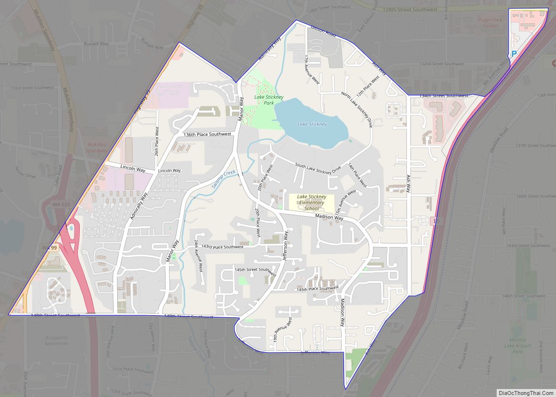
Map of East Cathlamet CDP

Map of East Cathlamet CDP

East Cathlamet is a census-designated place (CDP) in Wahkiakum County, Washington, on the eastern border of the town of Cathlamet. The population was 491 as of the 2010 census. The East Cathlamet community is part of the Wahkiakum School District, a K-12 school district of about 430 students. The name “Kathlamet” (Cathlamet) comes from the … Read more

Map of Duvall city

Map of Duvall city

Duvall is a city in King County, Washington, United States, located on SR 203 halfway between Monroe and Carnation. The population was 8,034 at the 2020 census. Duvall city overview: Name: Duvall city LSAD Code: 25 LSAD Description: city (suffix) State: Washington County: King County Elevation: 89 ft (27 m) Total Area: 2.47 sq mi (6.40 km²) Land Area: 2.45 sq mi … Read more

Map of DuPont city, Washington

Map of DuPont city, Washington

DuPont is a city in Pierce County, Washington, United States. The population was 10,151 at the 2020 census. Originally a company town, the city is named after the DuPont chemical company which operated an explosives manufacturing plant in the area from 1909 to 1975. DuPont city overview: Name: DuPont city LSAD Code: 25 LSAD Description: … Read more

Map of Duluth CDP, Washington

Map of Duluth CDP, Washington

Duluth is a census-designated place (CDP) in Clark County, Washington, United States. The population was 1,544 at the 2010 census. It is located 11 miles (18 km) north of downtown Vancouver, Washington, with access from Exit 11 on Interstate 5. Duluth CDP overview: Name: Duluth CDP LSAD Code: 57 LSAD Description: CDP (suffix) State: Washington County: … Read more

Map of Donald CDP, Washington

Map of Donald CDP, Washington

Donald is a census-designated place and unincorporated community in Yakima County, Washington, United States. The population was 91 at the 2010 census. Donald was founded in 1910 and was named after George Donald, an early railroad pioneer and the president of the North Yakima and Valley Railway Company. The town site, primarily a rural railroad … Read more

Map of Dollars Corner CDP

Map of Dollars Corner CDP

Dollars Corner is a census-designated place (CDP) in Clark County, Washington, United States. The population was 1,108 at the 2010 census. Dollars Corner CDP overview: Name: Dollars Corner CDP LSAD Code: 57 LSAD Description: CDP (suffix) State: Washington County: Clark County Elevation: 220 ft (67 m) Total Area: 3.9 sq mi (10.2 km²) Land Area: 3.9 sq mi (10.2 km²) Water Area: 0.0 sq mi … Read more

Map of Dixie CDP

Map of Dixie CDP, Washington

Dixie is a census-designated place (CDP) in Walla Walla County, Washington, United States. The population was 197 at the 2010 census. A post office called Dixie has been in operation since 1881. The community has one elementary school, which is part of the Walla Walla School District and feeds on to Pioneer Middle School and … Read more

Map of Disautel CDP

Map of Disautel CDP

Disautel is a census-designated place (CDP) in Okanogan County, Washington, United States, within the Greater Omak Area. The population was 78 at the 2010 census. Established in 1919, the community is located approximately 15 miles (24 km) east of Omak, along what is now Washington State Route 155. It was formerly a logging town that was … Read more

Map of Desert Aire CDP

Map of Desert Aire CDP

Desert Aire is a census-designated place (CDP) in Grant County, Washington, United States. Desert Aire’s elevation is 560 ft (170 m). The population was 1,626 at the 2010 census, up from 1,124 at the 2000 census. Desert Aire CDP overview: Name: Desert Aire CDP LSAD Code: 57 LSAD Description: CDP (suffix) State: Washington County: Grant County Elevation: … Read more

Map of Des Moines city, Washington

Map of Des Moines city, Washington

Des Moines (/dəˈmɔɪnz/ də-MOYNZ) is a city in King County, Washington, United States. The population was 32,888 as of the 2020 census. The city is located on the east shore of Puget Sound, near the center of the Seattle metropolitan area. It is bordered by the suburbs of Federal Way to the south, Kent to … Read more

Map of East Renton Highlands CDP

Map of East Renton Highlands CDP

East Renton Highlands is a census-designated place (CDP) in King County, Washington, United States, located between Issaquah and Renton. The population was 11,937 at the 2020 census. East Renton Highlands CDP overview: Name: East Renton Highlands CDP LSAD Code: 57 LSAD Description: CDP (suffix) State: Washington County: King County Elevation: 525 ft (160 m) Total Area: 11.4 sq mi … Read more

Map of East Port Orchard CDP

Map of East Port Orchard CDP

East Port Orchard is a census-designated place (CDP) in Kitsap County, Washington, United States. The population was 5,919 at the 2010 census. East Port Orchard CDP overview: Name: East Port Orchard CDP LSAD Code: 57 LSAD Description: CDP (suffix) State: Washington County: Kitsap County Elevation: 295 ft (90 m) Total Area: 2.5 sq mi (6.5 km²) Land Area: 2.5 sq mi (6.5 km²) … Read more