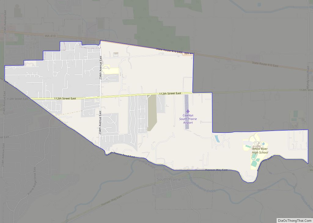
Map of Qui-nai-elt Village CDP
Qui-nai-elt Village is a census-designated place (CDP) in Grays Harbor County, Washington, United States. The population was 54 at the 2010 census. The community is in the southwestern part of the Quinault Indian Nation in western Grays Harbor County, about 2 miles (3 km) east of the Pacific Ocean. It is bordered to the south by ... Read more
Map of Qui-nai-elt Village CDP
Map of Port Gamble Tribal Community CDP
Port Gamble Tribal Community is a census-designated place (CDP) corresponding to the Port Gamble S’Klallam Reservation in Kitsap County, Washington, United States. The population was 916 at the 2010 census. Port Gamble Tribal Community CDP overview: Name: Port Gamble Tribal Community CDP LSAD Code: 57 LSAD Description: CDP (suffix) State: Washington County: Kitsap County Elevation: ... Read more
Map of Port Gamble Tribal Community CDP
Map of Queets CDP
Queets is an unincorporated community and census-designated place (CDP) in Grays Harbor and Jefferson counties, Washington, United States. The population was 174 at the 2010 census. The primary residents of the community are Native Americans of the Quinault Indian Nation. Queets CDP overview: Name: Queets CDP LSAD Code: 57 LSAD Description: CDP (suffix) State: Washington ... Read more
Map of Queets CDP
Map of River Road CDP, Washington
River Road is a census-designated place (CDP) in Clallam County, Washington, United States. The population was 454 at the 2010 census. It is a primarily residential area next to the city of Sequim. River Road CDP overview: Name: River Road CDP LSAD Code: 57 LSAD Description: CDP (suffix) State: Washington County: Clallam County Elevation: 315 ft ... Read more
Map of River Road CDP, Washington
Map of Ritzville city
Ritzville (/ˈrɪtsvɪl/) is a city in Adams County, Washington, United States. The population was 1,767 at the 2020 census. It is the county seat of Adams County. The city is part of the Othello, WA Micropolitan Area, which comprises all of Adams County, and is part of the larger Moses Lake-Othello, WA Combined Statistical Area. ... Read more
Map of Ritzville city
Map of Ridgefield city, Washington
Ridgefield is a city in northern Clark County, Washington, United States. The population was 10,319 at the time of the 2020 census, up from 4,763 in 2010, making it the fastest growing city in the state of Washington. Located within the Portland metropolitan area, Ridgefield is notable for the significant Native American history and connection ... Read more
Map of Ridgefield city, Washington
Map of Richland city, Washington
Richland (/ˈrɪtʃlənd/) is a city in Benton County, Washington, United States. It is located in southeastern Washington at the confluence of the Yakima and the Columbia Rivers. As of the 2020 census, the city’s population was 60,560. Along with the nearby cities of Pasco and Kennewick, Richland is one of the Tri-Cities, and is home ... Read more
Map of Richland city, Washington
Map of Republic city, Washington
Republic is a city in Ferry County, Washington, United States. The population was 1,073 at the 2010 census, a 12.5% increase over the 2000 census. It is the county seat of Ferry County. It was the largest mining camp in the Republic Mining District, and home to the “Hot Air Line” railway. Republic city overview: ... Read more
Map of Republic city, Washington
Map of Renton city
Renton is a city in King County, Washington, United States, and an inner-ring suburb of Seattle. Situated 11 miles (18 km) southeast of downtown Seattle, Renton straddles the southeast shore of Lake Washington, at the mouth of the Cedar River. As of the 2020 census, the population of Renton was 106,785, up from 90,927 at the ... Read more
Map of Renton city
Map of Redmond city, Washington
Redmond is a city in King County, Washington, United States, located 15 miles (24 km) east of Seattle. The population was 73,256 at the 2020 census, up from 54,144 in 2010. Redmond is best known as the home of Microsoft and Nintendo of America. With an annual bike race on city streets and the state’s only ... Read more
Map of Redmond city, Washington
Map of Reardan town
Reardan town overview: Name: Reardan town LSAD Code: 43 LSAD Description: town (suffix) State: Washington County: Lincoln County FIPS code: 5357465 Online Interactive Map Reardan online map. Source: Basemap layers from Google Map, Open Street Map (OSM), Arcgisonline, Wmflabs. Boundary Data from Database of Global Administrative Areas. Reardan location map. Where is Reardan town? Reardan ... Read more
Map of Reardan town
Map of Rocky Point CDP, Washington
Rocky Point is a census-designated place (CDP) in Kitsap County, Washington, United States. Rocky Point CDP overview: Name: Rocky Point CDP LSAD Code: 57 LSAD Description: CDP (suffix) State: Washington County: Kitsap County Elevation: 20 ft (6 m) Total Area: 0.76 sq mi (1.96 km²) Land Area: 0.75 sq mi (1.93 km²) Water Area: 0.008 sq mi (0.02 km²) Total Population: 1,564 Population Density: 2,096/sq mi (809.4/km²) ... Read more
Map of Rocky Point CDP, Washington