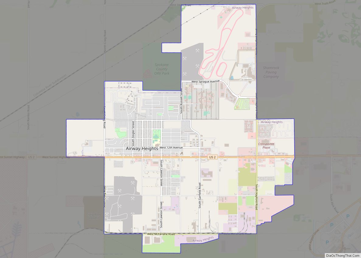
Map of Poulsbo city

Map of Poulsbo city

Poulsbo (/ˈpɔːlzboʊ/ PAWLZ-boh) is a city on Liberty Bay in Kitsap County, Washington, United States. It is the smallest of the four cities in Kitsap County. The population was 9,200 at the 2010 census and an estimated 10,927 in 2018. The area was historically inhabited by the Suquamish people, many of whom moved to the … Read more

Map of Porter CDP, Washington

Map of Porter CDP, Washington

Porter is an unincorporated community and census-designated place (CDP) in Grays Harbor County, Washington, United States. The population was 207 at the 2010 census. Prior to 2010 it was part of the Malone-Porter CDP; Malone and Porter are now separate CDPs. They are located just off U.S. Route 12, southeast of Elma and northwest of … Read more

Map of Port Townsend city

Map of Port Townsend city

Port Townsend /ˈtaʊnzənd/ is a city on the Quimper Peninsula in Jefferson County, Washington, United States. The population was 10,148 at the 2020 United States Census. It is the county seat and only incorporated city of Jefferson County. In addition to its natural scenery at the northeast tip of the Olympic Peninsula, the city is … Read more

Map of Raft Island CDP

Map of Raft Island CDP

Raft Island is a private island and CDP located near the Pierce County community of Rosedale, Washington, United States. Gig Harbor, Washington is the nearest incorporated town, although unincorporated Artondale is much closer. The island features approximately 200 homes on 160 acres. All of these homes are served through the Gig Harbor post office. Raft … Read more

Map of Port Orchard city

Map of Port Orchard city

Port Orchard is a city in and the county seat of Kitsap County, Washington, United States. It is located 13 miles (21 km) due west of West Seattle and is connected to Seattle and Vashon Island via the Washington State Ferries run to Southworth. It is named after Port Orchard, the strait that separates Bainbridge Island … Read more

Map of Quincy city, Washington

Map of Quincy city, Washington

Quincy is a city in Grant County, Washington, United States. The population was 7,543 at the 2020 census. Quincy city overview: Name: Quincy city LSAD Code: 25 LSAD Description: city (suffix) State: Washington County: Grant County Elevation: 1,302 ft (397 m) Total Area: 6.13 sq mi (15.88 km²) Land Area: 6.05 sq mi (15.67 km²) Water Area: 0.08 sq mi (0.21 km²) Total Population: 7,543 Population … Read more

Map of Port Ludlow CDP

Map of Port Ludlow CDP

Port Ludlow is an unincorporated community and census-designated place (CDP) in Jefferson County, Washington, United States. It is also the name of the marine inlet on which the community is located. The CDP’s population was 2,603 at the 2010 census, up from 1,968 at the 2000 census. Originally a logging and sawmill community, its economy … Read more

Map of Quilcene CDP

Map of Quilcene CDP

Quilcene is an unincorporated community and census-designated place (CDP) in Jefferson County, Washington, United States. The population was 596 at the 2010 census. The community is located on the Olympic Peninsula at the head of Quilcene Bay, an arm of the seawater-filled glacial valley of Hood Canal. Each year many visitors enjoy the panoramic views … Read more

Map of Port Hadlock-Irondale CDP

Map of Port Hadlock-Irondale CDP

Port Hadlock-Irondale is a census-designated place (CDP) in Jefferson County, Washington, United States. The population was 3,580 at the 2010 census. Port Hadlock-Irondale CDP overview: Name: Port Hadlock-Irondale CDP LSAD Code: 57 LSAD Description: CDP (suffix) State: Washington County: Jefferson County Elevation: 120 ft (40 m) Total Area: 7.8 sq mi (20.1 km²) Land Area: 6.7 sq mi (17.3 km²) Water Area: 1.1 sq mi … Read more

Map of Riverside town, Washington

Map of Riverside town, Washington

Riverside town overview: Name: Riverside town LSAD Code: 43 LSAD Description: town (suffix) State: Washington County: Okanogan County FIPS code: 5358795 Online Interactive Map Riverside online map. Source: Basemap layers from Google Map, Open Street Map (OSM), Arcgisonline, Wmflabs. Boundary Data from Database of Global Administrative Areas. Riverside location map. Where is Riverside town? Riverside … Read more

Map of Riverbend CDP, Washington

Map of Riverbend CDP, Washington

Riverbend is an unincorporated community and census-designated place (CDP) in King County, Washington, United States. The population was 2,132 at the 2010 census. Based on per capita income, one of the more reliable measures of affluence, Riverbend ranks 87th of 522 areas in the state of Washington to be ranked. Riverbend CDP overview: Name: Riverbend … Read more

Map of River Road CDP, Washington

Map of River Road CDP, Washington

River Road is a census-designated place (CDP) in Clallam County, Washington, United States. The population was 454 at the 2010 census. It is a primarily residential area next to the city of Sequim. River Road CDP overview: Name: River Road CDP LSAD Code: 57 LSAD Description: CDP (suffix) State: Washington County: Clallam County Elevation: 315 ft … Read more