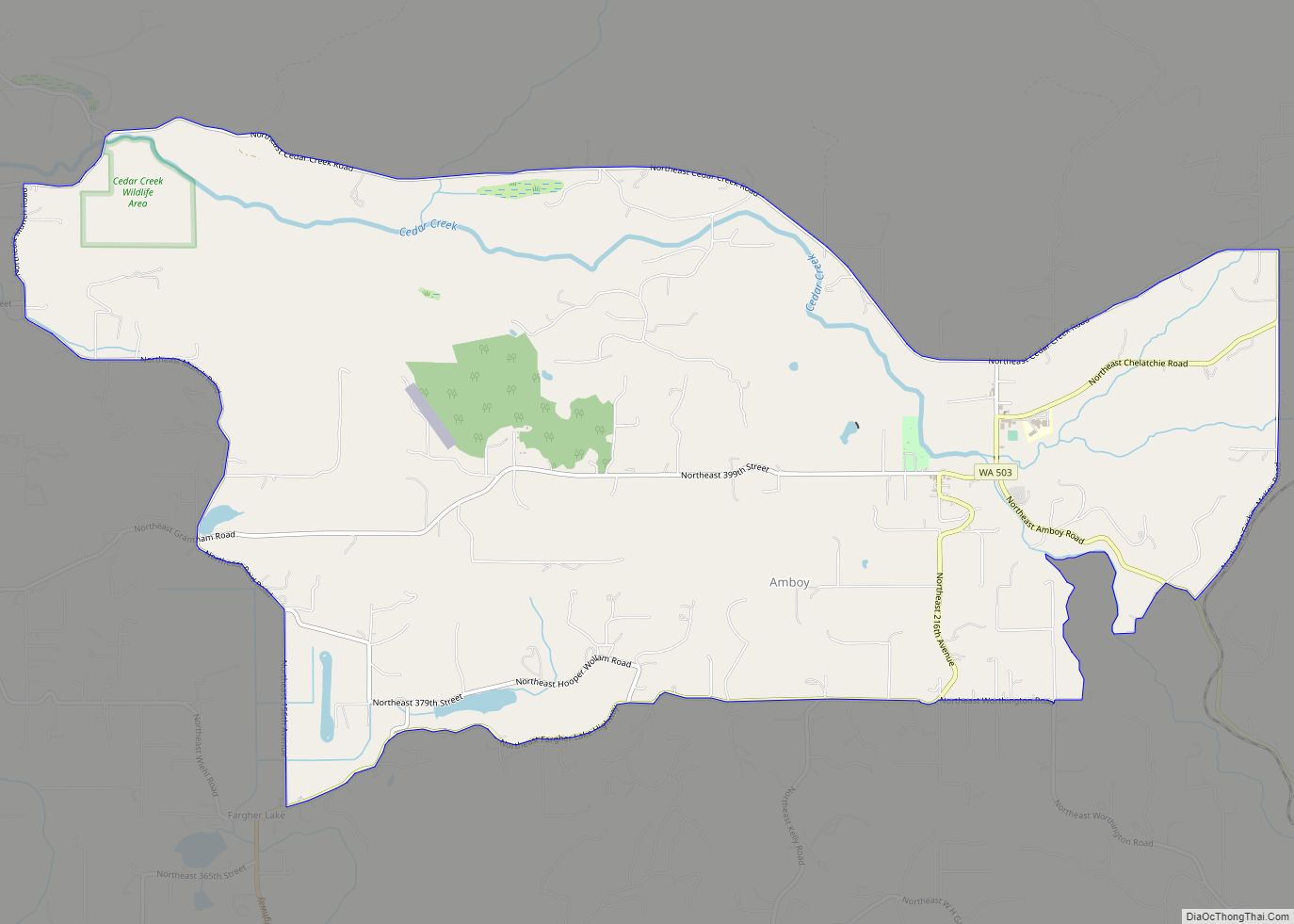
Map of Almira town
Almira town overview: Name: Almira town LSAD Code: 43 LSAD Description: town (suffix) State: Washington County: Lincoln County FIPS code: 5301500 Online Interactive Map Almira online map. Source: Basemap layers from Google Map, Open Street Map (OSM), Arcgisonline, Wmflabs. Boundary Data from Database of Global Administrative Areas. Almira location map. Where is Almira town? Almira ... Read more
Map of Almira town
Map of Ashford CDP, Washington
Ashford is a census-designated place (CDP) mostly within Pierce County, Washington, United States. Its population was 217 as of the 2010 census. The town is west of the main (Nisqually River) entrance to Mount Rainier National Park. Surrounding mountains and the narrow Nisqually River valley are heavily forested. Some of Ashford is across the Nisqually ... Read more
Map of Ashford CDP, Washington
Map of Barney’s Junction CDP
Barney’s Junction is a census-designated place in Ferry County, Washington, in the United States. Barney’s Junction CDP overview: Name: Barney’s Junction CDP LSAD Code: 57 LSAD Description: CDP (suffix) State: Washington County: Ferry County Elevation: 1,365 ft (416 m) Total Area: 0.26 sq mi (0.67 km²) Land Area: 0.26 sq mi (0.67 km²) Water Area: 0.0 sq mi (0.0 km²) Total Population: 146 Population Density: 561/sq mi ... Read more
Map of Barney’s Junction CDP
Map of Baring CDP, Washington
Baring is an unincorporated community and census-designated place (CDP) in King County, Washington, United States. The population was 220 at the 2010 United States Census. It is located on U.S. Highway 2 about 23 miles (37 km) west of Stevens Pass, along a very flat and straight three-mile section of highway that has been dubbed the ... Read more
Map of Baring CDP, Washington
Map of Barberton CDP, Washington
Barberton is a census-designated place (CDP) in Clark County, Washington, United States. The population was 5,661 at the 2010 census, up from 4,617 at the 2000 census. Based on per capita income, one of the more reliable measures of affluence, Barberton ranks 90th of 522 areas in the state of Washington to be ranked. Barberton ... Read more
Map of Barberton CDP, Washington
Map of Banks Lake South CDP
Banks Lake South is a census-designated place (CDP) in Grant County, Washington, United States. The population was 174 at the 2010 census. Banks Lake South CDP overview: Name: Banks Lake South CDP LSAD Code: 57 LSAD Description: CDP (suffix) State: Washington County: Grant County Elevation: 1,634 ft (498 m) Total Area: 2.9 sq mi (7.5 km²) Land Area: 2.4 sq mi (6.3 km²) ... Read more
Map of Banks Lake South CDP
Map of Bangor Base CDP
Bangor Base is a census-designated place (CDP) in Kitsap County, Washington, within U.S. Naval Base Kitsap on the Kitsap Peninsula. Its population was 6,054 at the 2010 census. Bangor Base CDP overview: Name: Bangor Base CDP LSAD Code: 57 LSAD Description: CDP (suffix) State: Washington County: Kitsap County Elevation: 380 ft (120 m) Total Area: 11.14 sq mi (28.84 km²) ... Read more
Map of Bangor Base CDP
Map of Bainbridge Island city
Bainbridge Island is a city and island in Kitsap County, Washington. It is located in Puget Sound. The population was 23,025 at the 2010 census and an estimated 25,298 in 2019, making Bainbridge Island the second largest city in Kitsap County. The island is separated from the Kitsap Peninsula by Port Orchard, with Bremerton lying ... Read more
Map of Bainbridge Island city
Map of Auburn city, Washington
Auburn is a city in King County, Washington, United States (with a small portion crossing into neighboring Pierce County). The population was 87,256 at the 2020 Census. Auburn is a suburb in the Seattle metropolitan area, and is currently ranked as the 14th largest city in the state of Washington. Auburn is bordered by the ... Read more
Map of Auburn city, Washington
Map of Asotin city
Asotin /əˈsoʊtən/ is the county seat of the county of the same name, in the state of Washington, United States. The population of the city was 1,204 at the 2020 census. It is part of the Lewiston, ID-WA Metropolitan Statistical Area. Asotin city overview: Name: Asotin city LSAD Code: 25 LSAD Description: city (suffix) State: ... Read more
Map of Asotin city
Map of Bell Hill CDP
Bell Hill is an unincorporated community and census-designated place (CDP) in Clallam County, Washington, United States. The population was 837 at the 2010 census, up from 731 at the 2000 census. Located just south of the city of Sequim, Bell Hill has become a fast-growing destination for the very wealthy, with a high population of ... Read more
Map of Bell Hill CDP
Map of Belfair CDP
Belfair is a census-designated place in Mason County, Washington, United States. Located at the mouth of the Union River at Hood Canal, it serves as the commercial center of North Mason County. The population of the surrounding area grows in the summertime, as the Canal and the Olympic Peninsula are popular with tourists. The population ... Read more
Map of Belfair CDP