Map of Fern Prairie CDP
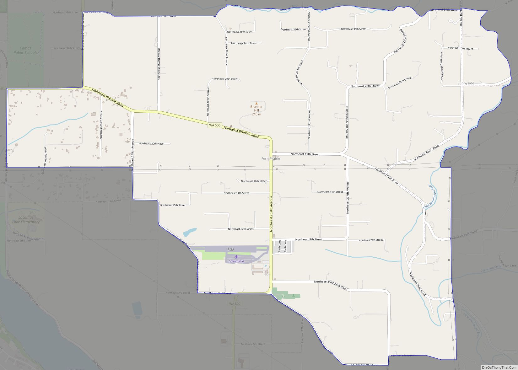
Fern Prairie is a census-designated place (CDP) in Clark County, Washington, United States. The population was 1,884 at the 2010 census. It is located in southern Clark County, 16 miles (26 km) east of downtown Vancouver and 4 miles (6 km) north of Camas. Fern Prairie CDP overview: Name: Fern Prairie CDP LSAD Code: 57 LSAD Description: ... Read more
Map of Fern Prairie CDP
Map of Fort Lewis CDP
Fort Lewis is a United States Army base located 9.1 miles (14.6 km) south-southwest of Tacoma, Washington. Fort Lewis was merged with McChord Air Force Base on 1 February 2010 to form Joint Base Lewis–McChord. Fort Lewis, named after Meriwether Lewis of the Lewis and Clark Expedition, was one of the largest and most modern military ... Read more
Map of Fort Lewis CDP
Map of Garrett CDP, Washington
Garrett is a census-designated place (CDP) in Walla Walla County, Washington, United States. The population was 1,419 at the 2010 census. Garrett CDP overview: Name: Garrett CDP LSAD Code: 57 LSAD Description: CDP (suffix) State: Washington County: Walla Walla County Elevation: 768 ft (234 m) Total Area: 2.1 sq mi (5.5 km²) Land Area: 2.1 sq mi (5.5 km²) Water Area: 0.0 sq mi (0.0 km²) ... Read more
Map of Garrett CDP, Washington
Map of Friday Harbor town
Friday Harbor town overview: Name: Friday Harbor town LSAD Code: 43 LSAD Description: town (suffix) State: Washington County: San Juan County FIPS code: 5325615 Online Interactive Map Friday Harbor online map. Source: Basemap layers from Google Map, Open Street Map (OSM), Arcgisonline, Wmflabs. Boundary Data from Database of Global Administrative Areas. Friday Harbor location map. ... Read more
Map of Friday Harbor town
Map of Freeland CDP, Washington
Freeland is an unincorporated community and census-designated place (CDP) on Whidbey Island in Island County, Washington, United States. At the time of the 2010 census the population was 7,812. The town received its name based on its origins as a socialist commune in the early 1900s: in the eyes of its founders, the land of ... Read more
Map of Freeland CDP, Washington
Map of Frederickson CDP
Frederickson is a census-designated place (CDP) in Pierce County, Washington, United States. The population was 24,906 at the 2020 census. Frederickson CDP overview: Name: Frederickson CDP LSAD Code: 57 LSAD Description: CDP (suffix) State: Washington County: Pierce County Elevation: 400 ft (122 m) Total Area: 7.3 sq mi (19.0 km²) Land Area: 7.3 sq mi (18.9 km²) Water Area: 0.0 sq mi (0.1 km²) Total Population: ... Read more
Map of Frederickson CDP
Map of Fox Island CDP
Fox Island is an island and census-designated place (CDP) in Pierce County, Washington, United States, in Puget Sound. It is located approximately 5 miles (8 km) from Gig Harbor. The island was named Fox by Charles Wilkes during the United States Exploring Expedition, to honor J.L. Fox, an assistant surgeon on the expedition. The population was ... Read more
Map of Fox Island CDP
Map of Graham CDP, Washington
Graham is a census-designated place (CDP) in Pierce County, Washington, United States. It is located 16 miles southeast of Tacoma. The population was 23,491 at the 2010 census and grew to 32,658 at the 2020 census. Graham CDP overview: Name: Graham CDP LSAD Code: 57 LSAD Description: CDP (suffix) State: Washington County: Pierce County Elevation: ... Read more
Map of Graham CDP, Washington
Map of Gorst CDP
Gorst is a census-designated place (CDP) at the head of Sinclair Inlet in Kitsap County, Washington, United States. The population was 592 at the 2010 census. Gorst, located on the shores of Puget Sound, is primarily a town consisting of stores, auto dealerships and espresso stands. A residential area, located west of the water along ... Read more
Map of Gorst CDP
Map of Gold Bar city
Gold Bar is a city in Snohomish County, Washington, United States. It is located on the Skykomish River between Sultan and Index, connected by U.S. Route 2. The population was 2,403 at the 2020 census. Gold Bar city overview: Name: Gold Bar city LSAD Code: 25 LSAD Description: city (suffix) State: Washington County: Snohomish County ... Read more
Map of Gold Bar city
Map of Glenwood CDP, Washington
Glenwood CDP overview: Name: Glenwood CDP LSAD Code: 57 LSAD Description: CDP (suffix) State: Washington FIPS code: 5327225 Online Interactive Map Glenwood online map. Source: Basemap layers from Google Map, Open Street Map (OSM), Arcgisonline, Wmflabs. Boundary Data from Database of Global Administrative Areas. Glenwood location map. Where is Glenwood CDP? Glenwood Road Map Glenwood ... Read more
Map of Glenwood CDP, Washington
Map of Glacier CDP
Glacier is a census-designated place in the North Fork Nooksack River Valley, at an elevation of 906 ft., just 10 miles northwest of the Mount Baker Summit towering nearly 10,000 ft above it, in Whatcom County, Washington, United States. The population was 211 at the 2010 census. Glacier is the community closest to Mt. Baker, ... Read more
Map of Glacier CDP