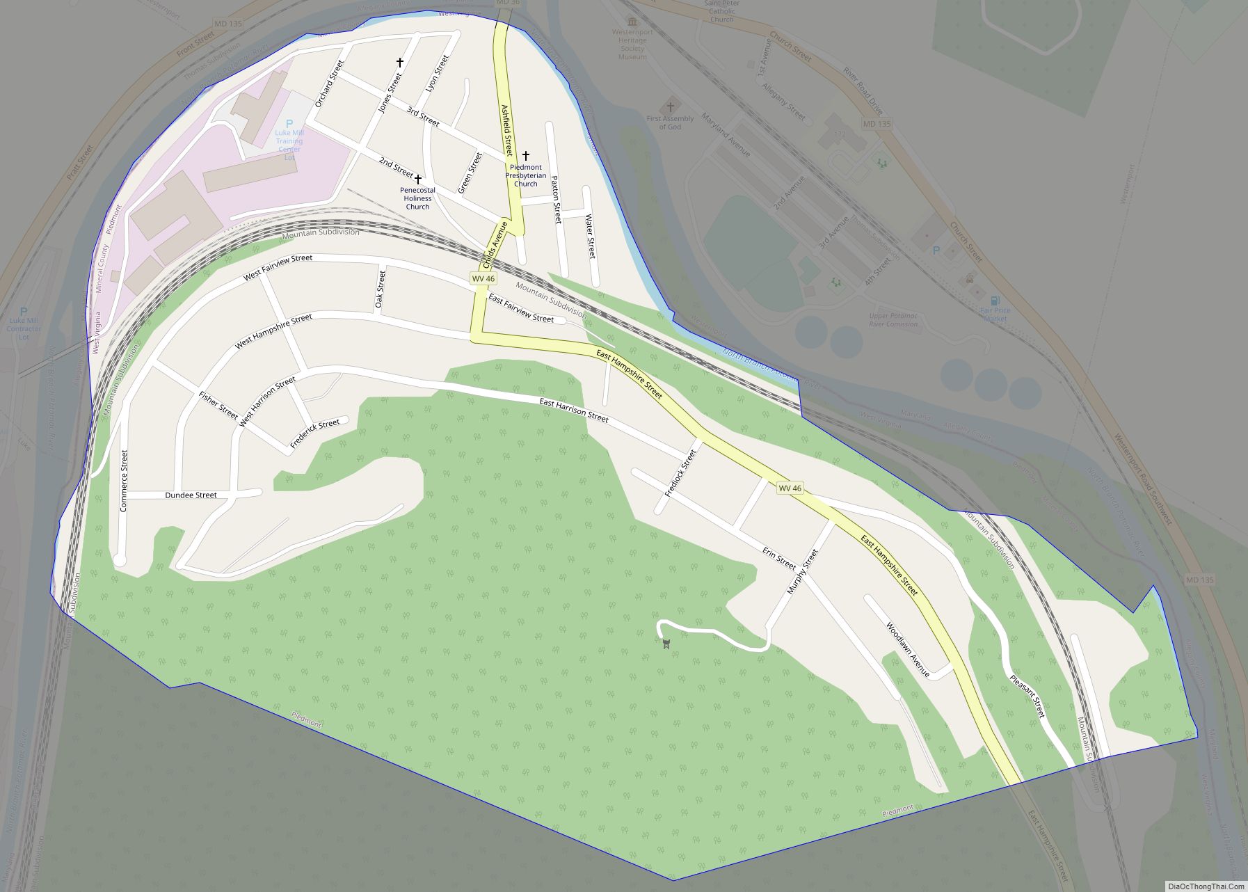
Map of Pennsboro city
Pennsboro is a city in Ritchie County, West Virginia, United States. The population was 1,050 at the 2020 census. The city is located at the junction of U.S. Route 50 and West Virginia Route 74; the North Bend Rail Trail also passes through the city. The town was platted circa 1820 by Charles Penn, and ... Read more
Map of Pennsboro city
Map of Pratt town, West Virginia
Pratt is a town in Kanawha County, West Virginia, United States, along the Kanawha River. The population was 482 at the 2020 census. Pratt town overview: Name: Pratt town LSAD Code: 43 LSAD Description: town (suffix) State: West Virginia County: Kanawha County Elevation: 633 ft (193 m) Total Area: 0.29 sq mi (0.76 km²) Land Area: 0.29 sq mi (0.74 km²) Water Area: ... Read more
Map of Pratt town, West Virginia
Map of Pea Ridge CDP, West Virginia
Pea Ridge is a census-designated place in Cabell County, West Virginia, United States. As of the 2020 census, the population was 6,602. It is part of the Huntington–Ashland metropolitan area. Pea Ridge CDP overview: Name: Pea Ridge CDP LSAD Code: 57 LSAD Description: CDP (suffix) State: West Virginia County: Cabell County Elevation: 627 ft (191 m) Total ... Read more
Map of Pea Ridge CDP, West Virginia
Map of Powellton CDP
Powellton is a census-designated place (CDP) in Fayette County, West Virginia, United States. The population was 619 at the 2010 census. The community most likely was named after Godwin H. Powell, a businessperson in the coal-mining industry. Powellton CDP overview: Name: Powellton CDP LSAD Code: 57 LSAD Description: CDP (suffix) State: West Virginia County: Fayette ... Read more
Map of Powellton CDP
Map of Pax town
Pax is a town in Fayette County, West Virginia, United States. The current mayor of Pax is William F. Hughes. The population was 167 at the 2010 census. The community most likely derives its name from nearby Packs Branch creek. Pax town overview: Name: Pax town LSAD Code: 43 LSAD Description: town (suffix) State: West ... Read more
Map of Pax town
Map of Paw Paw town, West Virginia
Paw Paw is a town in Morgan County, West Virginia, United States. The population was 410 at the 2020 census. The town is known for the nearby Paw Paw Tunnel. Paw Paw was incorporated by the Circuit Court of Morgan County on April 8, 1891, and named for the pawpaw, a wild fruit that grows ... Read more
Map of Paw Paw town, West Virginia
Map of Poca town
Poca is a town in Putnam County, West Virginia, United States. The population was 875 at the 2020 census. It is part of the Huntington–Ashland metropolitan area. The town derives its name from the Pocatalico River. Poca town overview: Name: Poca town LSAD Code: 43 LSAD Description: town (suffix) State: West Virginia County: Putnam County ... Read more
Map of Poca town
Map of Pleasant Valley city, West Virginia
Pleasant Valley is a city in Marion County, West Virginia, United States. The population was 3,506 at the 2020 census. Pleasant Valley city overview: Name: Pleasant Valley city LSAD Code: 25 LSAD Description: city (suffix) State: West Virginia County: Marion County Elevation: 1,030 ft (314 m) Total Area: 3.41 sq mi (8.82 km²) Land Area: 3.23 sq mi (8.37 km²) Water Area: 0.18 sq mi ... Read more
Map of Pleasant Valley city, West Virginia
Map of Piney View CDP
Piney View is a census-designated place (CDP) in Raleigh County, West Virginia, United States. The population was 989 at the 2010 census. Piney View CDP overview: Name: Piney View CDP LSAD Code: 57 LSAD Description: CDP (suffix) State: West Virginia County: Raleigh County Elevation: 2,336 ft (712 m) Total Area: 4.1 sq mi (10.5 km²) Land Area: 4.1 sq mi (10.4 km²) Water ... Read more
Map of Piney View CDP
Map of Pineville town, West Virginia
Pineville is a town in and the county seat of Wyoming County, West Virginia, United States, situated along the Guyandotte River. The population was 648 at the 2020 census. Pineville town overview: Name: Pineville town LSAD Code: 43 LSAD Description: town (suffix) State: West Virginia County: Wyoming County Elevation: 1,299 ft (396 m) Total Area: 0.81 sq mi (2.10 km²) ... Read more
Map of Pineville town, West Virginia
Map of Racine CDP, West Virginia
Racine is a census-designated place (CDP) in Boone County, West Virginia, United States. As of the 2010 census, its population was 256. The community was named after Racine, Ohio, the native home of first settlers. Racine is home to the Racine Volunteer Fire Department which covers 174 square miles (450 km) in its first response area. ... Read more
Map of Racine CDP, West Virginia
Map of Rachel CDP, West Virginia
Rachel is a census-designated place (CDP) in Marion County, West Virginia, United States. It is located along Buffalo Creek, 2 miles (3.2 km) east-southeast of Mannington. Rachel has a post office with ZIP code 26587. As of the 2010 census, its population was 248. Rachel is located on U.S. 250 between Farmington and Mannington. Rachel CDP ... Read more
Map of Rachel CDP, West Virginia