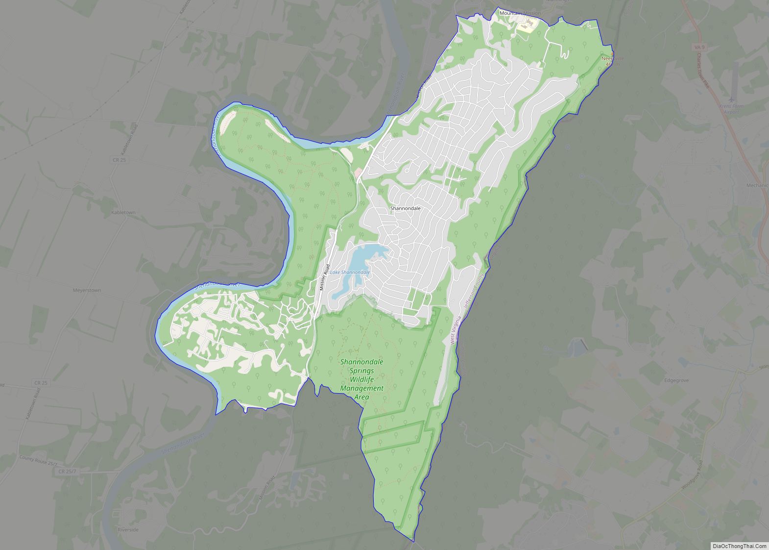
Map of Romney city
Romney is a town in and the county seat of Hampshire County, West Virginia, United States. The population was 1,722 at the 2020 census. It is part of the Winchester, Virginia metropolitan area. Established in 1762 along with Shepherdstown, they are the oldest towns in West Virginia. Romney city overview: Name: Romney city LSAD Code: ... Read more
Map of Romney city
Map of Shrewsbury CDP, West Virginia
Shrewsbury is a census-designated place (CDP) and unincorporated community in Kanawha County, West Virginia, United States. Shrewsbury is located on the north bank of the Kanawha River along U.S. Route 60. As of the 2010 census, its population was 652. Like the nearby community of Dickinson, Shrewsbury was given its name due to the early ... Read more
Map of Shrewsbury CDP, West Virginia
Map of Roderfield CDP
Roderfield is a census-designated place (CDP) in McDowell County, West Virginia, United States. Roderfield is 7 miles (11 km) west-northwest of Welch. Roderfield has a post office with ZIP code 24881. As of the 2010 census, its population is 188. The community was named after Roderfield Iager, the original owner of the town site. Roderfield CDP ... Read more
Map of Roderfield CDP
Map of Shinnston city
Shinnston is a city and former coal town in Harrison County, West Virginia, United States, along the West Fork River. In 1778, Levi Shinn constructed his log home along what is now Route 19; today it is the oldest standing structure in north-central West Virginia. As of the 2020 census, Shinnston had a population of ... Read more
Map of Shinnston city
Map of Robinette CDP
Robinette is an unincorporated community and census-designated place (CDP) in Logan County, West Virginia, United States, along Buffalo Creek. Its population was 663 as of the 2010 census. Prior to 2010, Robinette was part of the Amherstdale-Robinette CDP. Robinette CDP overview: Name: Robinette CDP LSAD Code: 57 LSAD Description: CDP (suffix) State: West Virginia County: ... Read more
Map of Robinette CDP
Map of Star City town, West Virginia
Star City is a town in Monongalia County, West Virginia, United States. The population was 1,779 at the 2020 census. It is included in the Morgantown, West Virginia Metropolitan Statistical Area. Star City town overview: Name: Star City town LSAD Code: 43 LSAD Description: town (suffix) State: West Virginia County: Monongalia County Elevation: 955 ft (291 m) ... Read more
Map of Star City town, West Virginia
Map of Stanaford CDP
Stanaford is a census-designated place (CDP) and coal town in Raleigh County, West Virginia, United States. The population was 1,350 at the 2010 census. The community was named after nearby Stanaford Branch. Stanaford CDP overview: Name: Stanaford CDP LSAD Code: 57 LSAD Description: CDP (suffix) State: West Virginia County: Raleigh County Elevation: 2,402 ft (732 m) Total ... Read more
Map of Stanaford CDP
Map of St. Marys city, West Virginia
St. Marys is a city and the county seat of Pleasants County, West Virginia, United States. The population was 1,847 at the 2020 census. It is part of the Parkersburg–Vienna metropolitan area. St. Marys was established in 1849 by Alexander Creel, who is said to have had a vision of Mary while passing the townsite ... Read more
Map of St. Marys city, West Virginia
Map of St. George CDP, West Virginia
St. George CDP overview: Name: St. George CDP LSAD Code: 57 LSAD Description: CDP (suffix) State: West Virginia FIPS code: 5471284 Online Interactive Map St. George online map. Source: Basemap layers from Google Map, Open Street Map (OSM), Arcgisonline, Wmflabs. Boundary Data from Database of Global Administrative Areas. St. George location map. Where is St. ... Read more
Map of St. George CDP, West Virginia
Map of St. Albans city, West Virginia
St. Albans is a city in western Kanawha County, West Virginia, United States, at the confluence of the Kanawha and Coal rivers. The population was 10,861 at the 2020 census. It is part of the Charleston metropolitan area. St. Albans city overview: Name: St. Albans city LSAD Code: 25 LSAD Description: city (suffix) State: West ... Read more
Map of St. Albans city, West Virginia
Map of Springfield CDP, West Virginia
Springfield is a census-designated place (CDP) in northwestern Hampshire County in the U.S. state of West Virginia. As of the 2010 census, Springfield had a population of 477. Springfield is located north of Romney along West Virginia Route 28 at its junction with Green Spring Road (West Virginia Secondary Route 1) and Springfield Pike (West ... Read more
Map of Springfield CDP, West Virginia
Map of Spencer city, West Virginia
Spencer is a city in and the county seat of Roane County, West Virginia, United States. Originally known as “California,” Spencer was chartered in 1858, and named after Spencer Roane (1762–1822), a distinguished jurist from Virginia, who served on the Virginia Supreme Court of Appeals, and for whom Roane County was named. The population was ... Read more
Map of Spencer city, West Virginia