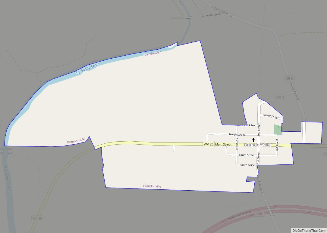
Map of Pea Ridge CDP, West Virginia

Map of Pea Ridge CDP, West Virginia

Pea Ridge is a census-designated place in Cabell County, West Virginia, United States. As of the 2020 census, the population was 6,602. It is part of the Huntington–Ashland metropolitan area. Pea Ridge CDP overview: Name: Pea Ridge CDP LSAD Code: 57 LSAD Description: CDP (suffix) State: West Virginia County: Cabell County Elevation: 627 ft (191 m) Total … Read more

Map of Powellton CDP

Map of Powellton CDP

Powellton is a census-designated place (CDP) in Fayette County, West Virginia, United States. The population was 619 at the 2010 census. The community most likely was named after Godwin H. Powell, a businessperson in the coal-mining industry. Powellton CDP overview: Name: Powellton CDP LSAD Code: 57 LSAD Description: CDP (suffix) State: West Virginia County: Fayette … Read more

Map of Pax town

Map of Pax town

Pax is a town in Fayette County, West Virginia, United States. The current mayor of Pax is William F. Hughes. The population was 167 at the 2010 census. The community most likely derives its name from nearby Packs Branch creek. Pax town overview: Name: Pax town LSAD Code: 43 LSAD Description: town (suffix) State: West … Read more

Map of Point Pleasant city, West Virginia

Map of Point Pleasant city, West Virginia

Point Pleasant is a city in and the county seat of Mason County, West Virginia, United States, at the confluence of the Ohio and Kanawha Rivers. The population was 4,101 at the 2020 census. It is the principal city of the Point Pleasant micropolitan area extending into Ohio. The town is known for the Mothman, … Read more

Map of Paw Paw town, West Virginia

Map of Paw Paw town, West Virginia

Paw Paw is a town in Morgan County, West Virginia, United States. The population was 410 at the 2020 census. The town is known for the nearby Paw Paw Tunnel. Paw Paw was incorporated by the Circuit Court of Morgan County on April 8, 1891, and named for the pawpaw, a wild fruit that grows … Read more

Map of Poca town

Map of Poca town

Poca is a town in Putnam County, West Virginia, United States. The population was 875 at the 2020 census. It is part of the Huntington–Ashland metropolitan area. The town derives its name from the Pocatalico River. Poca town overview: Name: Poca town LSAD Code: 43 LSAD Description: town (suffix) State: West Virginia County: Putnam County … Read more

Map of Pleasant Valley city, West Virginia

Map of Pleasant Valley city, West Virginia

Pleasant Valley is a city in Marion County, West Virginia, United States. The population was 3,506 at the 2020 census. Pleasant Valley city overview: Name: Pleasant Valley city LSAD Code: 25 LSAD Description: city (suffix) State: West Virginia County: Marion County Elevation: 1,030 ft (314 m) Total Area: 3.41 sq mi (8.82 km²) Land Area: 3.23 sq mi (8.37 km²) Water Area: 0.18 sq mi … Read more

Map of Piney View CDP

Map of Piney View CDP

Piney View is a census-designated place (CDP) in Raleigh County, West Virginia, United States. The population was 989 at the 2010 census. Piney View CDP overview: Name: Piney View CDP LSAD Code: 57 LSAD Description: CDP (suffix) State: West Virginia County: Raleigh County Elevation: 2,336 ft (712 m) Total Area: 4.1 sq mi (10.5 km²) Land Area: 4.1 sq mi (10.4 km²) Water … Read more

Map of Pineville town, West Virginia

Map of Pineville town, West Virginia

Pineville is a town in and the county seat of Wyoming County, West Virginia, United States, situated along the Guyandotte River. The population was 648 at the 2020 census. Pineville town overview: Name: Pineville town LSAD Code: 43 LSAD Description: town (suffix) State: West Virginia County: Wyoming County Elevation: 1,299 ft (396 m) Total Area: 0.81 sq mi (2.10 km²) … Read more

Map of Pine Grove town, West Virginia

Map of Pine Grove town, West Virginia

Pine Grove is a town in Wetzel County, West Virginia, United States. The population was 363 at the 2020 census. The community was named for a grove of pine trees near the original town site. The town is one mile north of Dominion Energy’s large Hastings Extraction Station, which separates natural gas into various subproducts … Read more

Map of Pinch CDP

Map of Pinch CDP

Pinch is a census-designated place (CDP) in Kanawha County, West Virginia, United States. The population was 3,262 at the 2010 census. The community was named after nearby Pinch Creek. Pinch CDP overview: Name: Pinch CDP LSAD Code: 57 LSAD Description: CDP (suffix) State: West Virginia County: Kanawha County Elevation: 715 ft (218 m) Total Area: 3.6 sq mi (9.3 km²) … Read more

Map of Piedmont town, West Virginia

Map of Piedmont town, West Virginia

Piedmont is a town in Mineral County, West Virginia, United States. It is part of the Cumberland, MD–WV metropolitan statistical area. The population was 716 at the 2020 census. Piedmont was chartered in 1856 and the town is the subject of Colored People: A Memoir by Piedmont native Henry Louis Gates Jr. Piedmont town overview: … Read more