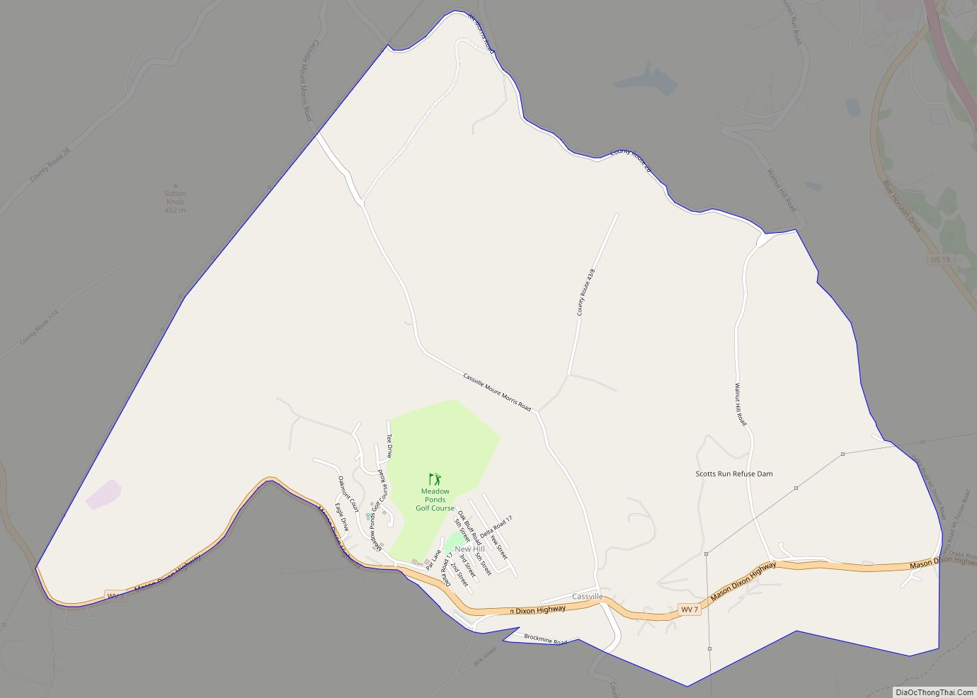
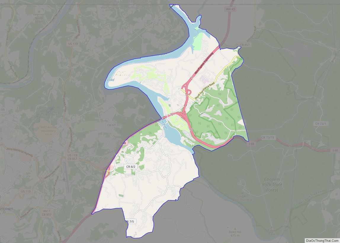
Map of Buckhannon city
Buckhannon is the only incorporated city in, and the county seat of, Upshur County, West Virginia, United States, along the Buckhannon River. The population was 5,299 as of the 2020 census. The city is located 60 miles southwest of Morgantown, 115 miles northeast of the capital city of Charleston, and 140 miles south of Pittsburgh, ... Read more
Map of Buckhannon city
Map of Ceredo city
Ceredo is a town in Wayne County, West Virginia, United States, situated along the Ohio River. The population was 1,450 at the 2010 census. Ceredo is a part of the Huntington-Ashland, WV-KY-OH Metropolitan Statistical Area (MSA). As of the 2000 census, the MSA had a population of 288,649. The city is also near the location ... Read more
Map of Ceredo city
Map of Century CDP, West Virginia
Century is a census-designated place and coal town in Barbour County, West Virginia, United States. Its population was 115 as of the 2010 census. The community’s coal deposits were believed to be abundant enough to last a century, hence the name. Century CDP overview: Name: Century CDP LSAD Code: 57 LSAD Description: CDP (suffix) State: ... Read more
Map of Century CDP, West Virginia
Map of Clearview village, West Virginia
Clearview is a village in Ohio County, West Virginia, United States. It is part of the Wheeling, West Virginia Metropolitan Statistical Area. The population was 565 at the 2010 census. Clearview village overview: Name: Clearview village LSAD Code: 47 LSAD Description: village (suffix) State: West Virginia County: Ohio County Elevation: 1,093 ft (333 m) Total Area: 0.40 sq mi ... Read more
Map of Clearview village, West Virginia
Map of Clay town, West Virginia
Clay is a town in and the county seat of Clay County, West Virginia, United States. The population was 399 at the 2020 census. It is the only incorporated town in Clay County. Clay town overview: Name: Clay town LSAD Code: 43 LSAD Description: town (suffix) State: West Virginia County: Clay County Elevation: 709 ft (216 m) ... Read more
Map of Clay town, West Virginia
Map of Chester city, West Virginia
Chester is a city in northern Hancock County, West Virginia, United States, along the Ohio River. The population was 2,214 at the 2020 census. Located immediately south of Ohio and just west of Pennsylvania, Chester is the northernmost city in West Virginia. It is a part of the Weirton–Steubenville metropolitan area, and is home to ... Read more
Map of Chester city, West Virginia
Map of Cheat Lake CDP
Cheat Lake is a census-designated place in Monongalia County, West Virginia, United States, surrounding the Cheat Lake reservoir. The population was 9,930 at the 2020 census. It is included in the Morgantown metropolitan area. Cheat Lake CDP overview: Name: Cheat Lake CDP LSAD Code: 57 LSAD Description: CDP (suffix) State: West Virginia County: Monongalia County ... Read more
Map of Cheat Lake CDP
Map of Crab Orchard CDP, West Virginia
Crab Orchard is a census-designated place (CDP) in Raleigh County, West Virginia, United States. The population was 2,678 at the 2010 census. Crab Orchard CDP overview: Name: Crab Orchard CDP LSAD Code: 57 LSAD Description: CDP (suffix) State: West Virginia County: Raleigh County Elevation: 2,287 ft (697 m) Total Area: 2.2 sq mi (5.8 km²) Land Area: 2.2 sq mi (5.8 km²) Water ... Read more
Map of Crab Orchard CDP, West Virginia
Map of Chattaroy CDP
Chattaroy is a census-designated place (CDP) in Mingo County, West Virginia, United States. The population was 756 at the 2010 census. The community’s name is an accurate preservation of the Native American name of the nearby Big Sandy River, Chattaroy. Chattaroy CDP overview: Name: Chattaroy CDP LSAD Code: 57 LSAD Description: CDP (suffix) State: West ... Read more
Map of Chattaroy CDP
Map of Cowen town
Cowen is a town in Webster County, West Virginia, United States. The population was 488 at the 2020 census. Cowen town overview: Name: Cowen town LSAD Code: 43 LSAD Description: town (suffix) State: West Virginia County: Webster County Elevation: 2,270 ft (692 m) Total Area: 0.63 sq mi (1.63 km²) Land Area: 0.63 sq mi (1.63 km²) Water Area: 0.00 sq mi (0.00 km²) Total Population: ... Read more
Map of Cowen town
Map of Charles Town city
Charles Town is a city in and the county seat of Jefferson County, West Virginia, United States. The population was 6,534 at the 2020 census. The city is named for its founder Charles Washington, youngest brother of President George Washington. It is part of the northwestern fringes of the Washington metropolitan area. Charles Town city ... Read more
Map of Charles Town city
Map of Comfort CDP, West Virginia
Comfort is a census-designated place (CDP) in Boone County, West Virginia, United States. Comfort is located on West Virginia Route 3, 12 miles (19 km) northeast of Madison. Comfort has a post office with ZIP code 25049. As of the 2010 census, its population is 306. Comfort is the home of Sherman Elementary School. Comfort CDP ... Read more
Map of Comfort CDP, West Virginia