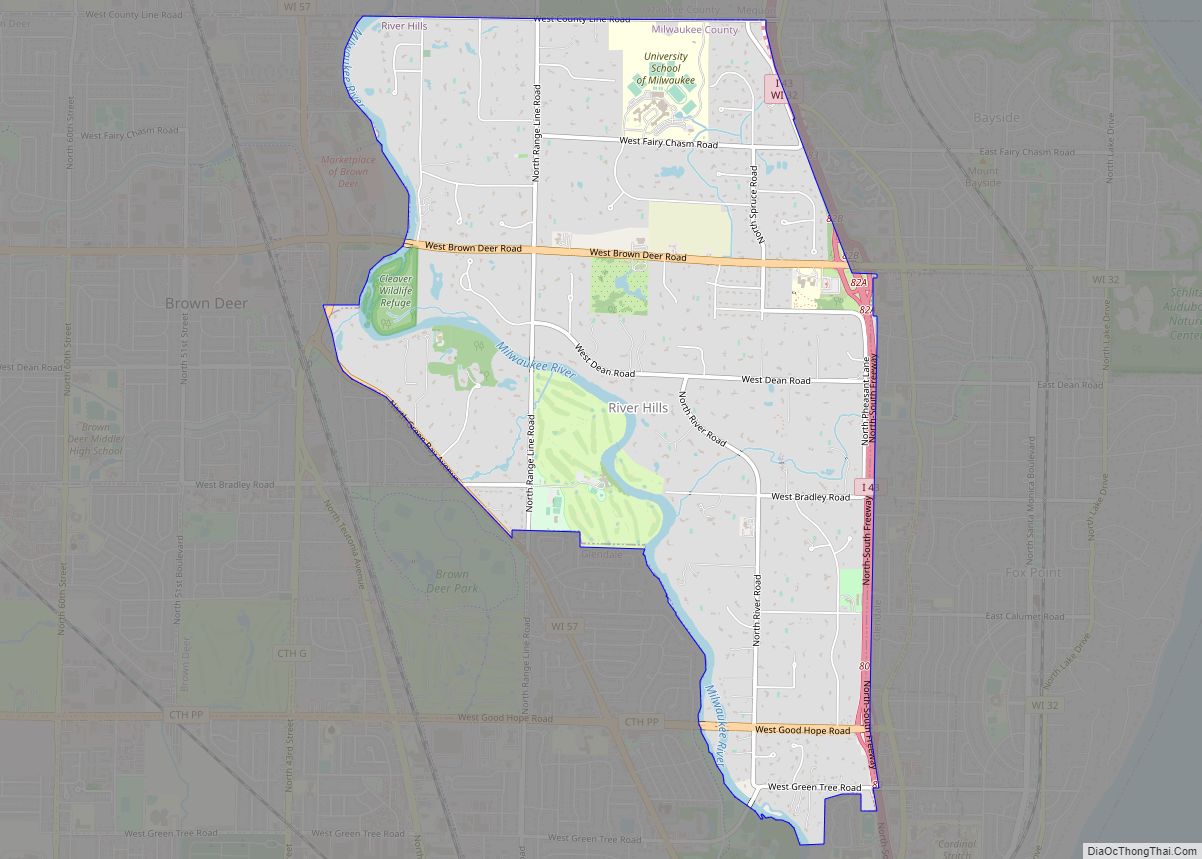
Map of Rudolph village, Wisconsin
The Town of Rudolph is located in Wood County, Wisconsin, in the United States. As of the 2000 census, the town population was 1,161. The Village of Rudolph is located within the town. Rudolph village overview: Name: Rudolph village LSAD Code: 47 LSAD Description: village (suffix) State: Wisconsin County: Wood County Total Area: 29.7 sq mi (77.0 km²) ... Read more
Map of Rudolph village, Wisconsin
Map of Richland Center city
Richland Center is a city in Richland County, Wisconsin, United States that also serves as the county seat. The population was 5,114 at the 2020 census. Richland Center city overview: Name: Richland Center city LSAD Code: 25 LSAD Description: city (suffix) State: Wisconsin County: Richland County Elevation: 728 ft (222 m) Total Area: 4.77 sq mi (12.36 km²) Land Area: ... Read more
Map of Richland Center city
Map of Rothschild village
Rothschild is a village in Marathon County, Wisconsin, United States. It is part of the Wausau, Wisconsin Metropolitan Statistical Area. The population was 5,567 at the 2020 census. Rothschild is the northern terminus of Interstate 39, which starts in Normal, Illinois. Rothschild village overview: Name: Rothschild village LSAD Code: 47 LSAD Description: village (suffix) State: ... Read more
Map of Rothschild village
Map of Richfield village, Wisconsin
Richfield is a village in Washington County, Wisconsin, United States. The population was 11,739 at the 2020 census. The previously unincorporated communities of Hubertus and Pleasant Hill are located in the village, as well as the communities of Colgate and Lake Five, which are partially located in Richfield. Richfield village overview: Name: Richfield village LSAD ... Read more
Map of Richfield village, Wisconsin
Map of Rosholt village, Wisconsin
Rosholt is a village in Portage County, Wisconsin, United States. The population was 478 at the 2020 census. Rosholt village overview: Name: Rosholt village LSAD Code: 47 LSAD Description: village (suffix) State: Wisconsin County: Portage County Elevation: 1,138 ft (347 m) Total Area: 1.09 sq mi (2.81 km²) Land Area: 1.05 sq mi (2.72 km²) Water Area: 0.04 sq mi (0.09 km²) Total Population: 478 Population ... Read more
Map of Rosholt village, Wisconsin
Map of Rice Lake city, Wisconsin
Rice Lake is a city in Barron County, Wisconsin, United States. As of the 2020 census, the city had a total population of 9,040. The city is located mostly within the Town of Rice Lake. Rice Lake city overview: Name: Rice Lake city LSAD Code: 25 LSAD Description: city (suffix) State: Wisconsin County: Barron County ... Read more
Map of Rice Lake city, Wisconsin
Map of Rosendale village, Wisconsin
Rosendale is a town in Fond du Lac County, Wisconsin, United States. The population was 783 at the 2000 census. The village of Rosendale is located partially within the town. The unincorporated communities of Rosendale Center and West Rosendale are also located in the town. Rosendale village overview: Name: Rosendale village LSAD Code: 47 LSAD ... Read more
Map of Rosendale village, Wisconsin
Map of Rib Mountain CDP
Rib Mountain is a census-designated place (CDP) in the town of Rib Mountain in Marathon County, Wisconsin, United States. The population was 6,061 at the 2020 census. The community is named for Rib Mountain. Rib Mountain CDP overview: Name: Rib Mountain CDP LSAD Code: 57 LSAD Description: CDP (suffix) State: Wisconsin County: Marathon County Total ... Read more
Map of Rib Mountain CDP
Map of Rome CDP, Wisconsin
Rome is a census-designated place (CDP) in the town of Sullivan in Jefferson County, Wisconsin, United States, along the Bark River. The population was 752 at the 2020 census. Rome CDP overview: Name: Rome CDP LSAD Code: 57 LSAD Description: CDP (suffix) State: Wisconsin County: Jefferson County Elevation: 840 ft (260 m) Total Area: 3.945 sq mi (10.22 km²) Land ... Read more
Map of Rome CDP, Wisconsin
Map of Rockland village, Wisconsin
Rockland is a village in eastern La Crosse County, Wisconsin, United States, along the La Crosse River. It is part of the La Crosse, Wisconsin Metropolitan Statistical Area. The population was 765 at the 2020 census. Rockland village overview: Name: Rockland village LSAD Code: 47 LSAD Description: village (suffix) State: Wisconsin County: La Crosse County ... Read more
Map of Rockland village, Wisconsin
Map of Rockdale village, Wisconsin
Rockdale is a village in Dane County, Wisconsin, United States. The population was 207 at the 2020 census. The village is split in half by the Koshkonong Creek. It is part of the Madison Metropolitan Statistical Area. Rockdale village overview: Name: Rockdale village LSAD Code: 47 LSAD Description: village (suffix) State: Wisconsin County: Dane County ... Read more
Map of Rockdale village, Wisconsin
Map of Rock Springs village, Wisconsin
Rock Springs is a village in Sauk County, Wisconsin, United States, along the Baraboo River. The population was 362 at the 2010 census. Rock Springs village overview: Name: Rock Springs village LSAD Code: 47 LSAD Description: village (suffix) State: Wisconsin County: Sauk County Elevation: 974 ft (297 m) Total Area: 1.33 sq mi (3.45 km²) Land Area: 1.30 sq mi (3.37 km²) Water ... Read more
Map of Rock Springs village, Wisconsin