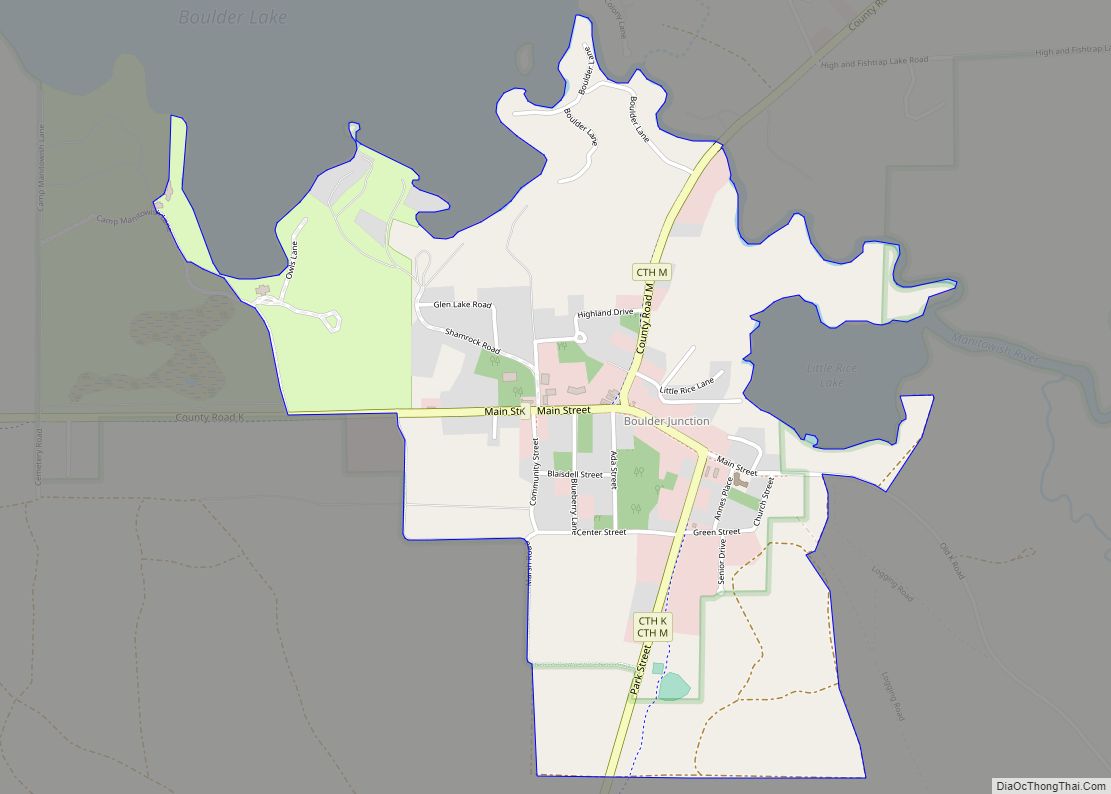
Map of Boaz village, Wisconsin
Boaz is a village in Richland County, Wisconsin, United States. According to the 2010 census, the population of the village was 156. Boaz village overview: Name: Boaz village LSAD Code: 47 LSAD Description: village (suffix) State: Wisconsin County: Richland County Elevation: 751 ft (229 m) Total Area: 0.36 sq mi (0.93 km²) Land Area: 0.36 sq mi (0.93 km²) Water Area: 0.00 sq mi (0.00 km²) ... Read more
Map of Boaz village, Wisconsin
Map of Bluffview CDP
Bluffview is a census-designated place in the town of Sumpter, Sauk County, Wisconsin, United States, with a North Freedom address. Bluffview CDP overview: Name: Bluffview CDP LSAD Code: 57 LSAD Description: CDP (suffix) State: Wisconsin County: Sauk County Elevation: 860 ft (260 m) Total Area: 0.388 sq mi (1.00 km²) Land Area: 0.385 sq mi (1.00 km²) Water Area: 0.003 sq mi (0.008 km²) Total Population: ... Read more
Map of Bluffview CDP
Map of Blue Mounds village
Blue Mounds is a town in Dane County, Wisconsin, United States. The population was 899 at the 2020 census. The Village of Blue Mounds is located within the town. Blue Mounds village overview: Name: Blue Mounds village LSAD Code: 47 LSAD Description: village (suffix) State: Wisconsin County: Dane County Total Area: 899 FIPS code: 5508475 ... Read more
Map of Blue Mounds village
Map of Bloomington village, Wisconsin
Bloomington is a town in Grant County, Wisconsin, United States. The population was 399 at the 2000 census. The Village of Bloomington is located within the town. Bloomington village overview: Name: Bloomington village LSAD Code: 47 LSAD Description: village (suffix) State: Wisconsin County: Grant County FIPS code: 5508375 Online Interactive Map Bloomington online map. Source: ... Read more
Map of Bloomington village, Wisconsin
Map of Bloomfield village, Wisconsin
Bloomfield is a village in Walworth County, Wisconsin, United States. The village was created on December 20, 2011, from unincorporated areas of the Town of Bloomfield. It includes all of the Pell Lake census-designated place and part of the Powers Lake census-designated place. Bloomfield village overview: Name: Bloomfield village LSAD Code: 47 LSAD Description: village ... Read more
Map of Bloomfield village, Wisconsin
Map of Brice Prairie CDP
Brice Prairie is a census-designated place (CDP) in La Crosse County, Wisconsin, United States. The population was 1,887 at the 2010 census. Brice Prairie is located in the town of Onalaska. Brice Prairie CDP overview: Name: Brice Prairie CDP LSAD Code: 57 LSAD Description: CDP (suffix) State: Wisconsin County: La Crosse County Elevation: 666 ft (203 m) ... Read more
Map of Brice Prairie CDP
Map of Burnett CDP
Burnett is an unincorporated census-designated place located in the town of Burnett, Dodge County, Wisconsin, United States. Burnett is located on Wisconsin Highway 26 5.5 miles (8.9 km) northwest of Horicon. Burnett has a post office with ZIP code 53922. As of the 2010 census, its population is 256. Burnett CDP overview: Name: Burnett CDP LSAD ... Read more
Map of Burnett CDP
Map of Boyceville village
Boyceville is a village in Dunn County, Wisconsin, United States. The population was 1,100 at the 2020 census. Boyceville village overview: Name: Boyceville village LSAD Code: 47 LSAD Description: village (suffix) State: Wisconsin County: Dunn County Elevation: 945 ft (288 m) Total Area: 3.79 sq mi (9.83 km²) Land Area: 3.76 sq mi (9.74 km²) Water Area: 0.04 sq mi (0.09 km²) Total Population: 1,100 Population ... Read more
Map of Boyceville village
Map of Buffalo City
Buffalo City is a city in Buffalo County in the U.S. state of Wisconsin. The population was 1,023 at the 2010 census. Buffalo City city overview: Name: Buffalo City city LSAD Code: 25 LSAD Description: city (suffix) State: Wisconsin County: Buffalo County Elevation: 669 ft (204 m) Total Area: 4.00 sq mi (10.35 km²) Land Area: 1.64 sq mi (4.26 km²) Water Area: ... Read more
Map of Buffalo City
Map of Brownsville village, Wisconsin
Brownsville is a village in Dodge County, Wisconsin, United States. The population was 581 at the 2010 census. Brownsville village overview: Name: Brownsville village LSAD Code: 47 LSAD Description: village (suffix) State: Wisconsin County: Dodge County Elevation: 997 ft (304 m) Total Area: 0.61 sq mi (1.59 km²) Land Area: 0.61 sq mi (1.59 km²) Water Area: 0.00 sq mi (0.00 km²) Total Population: 581 Population ... Read more
Map of Brownsville village, Wisconsin
Map of Catawba village, Wisconsin
Catawba is a village in Price County, Wisconsin, United States. The population was 110 at the 2010 census. The village is located within the Town of Catawba. Catawba village overview: Name: Catawba village LSAD Code: 47 LSAD Description: village (suffix) State: Wisconsin County: Price County Total Area: 4.44 sq mi (11.49 km²) Land Area: 4.44 sq mi (11.49 km²) Water Area: ... Read more
Map of Catawba village, Wisconsin
Map of Cataract CDP
Cataract is a census-designated place (CDP) in the Town of Little Falls in Monroe County, Wisconsin, United States. As of the 2010 census, its population was 186. Cataract CDP overview: Name: Cataract CDP LSAD Code: 57 LSAD Description: CDP (suffix) State: Wisconsin County: Monroe County Elevation: 850 ft (260 m) Total Area: 0.594 sq mi (1.54 km²) Land Area: 0.594 sq mi ... Read more
Map of Cataract CDP