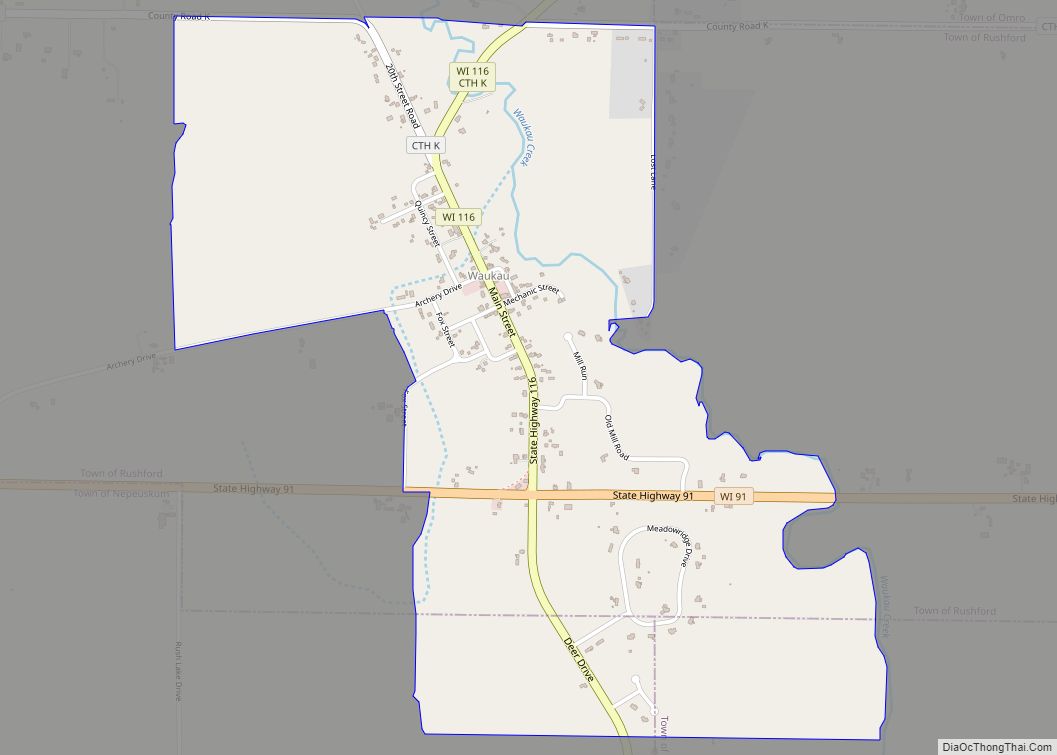
Map of Waterloo city, Wisconsin
Waterloo is a city in Jefferson County in the U.S. state of Wisconsin. As of the census of 2020, the population was 3,483. The name Waterloo was suggested by Mr. Wilt, a Frenchman living here, who was one of Napoleon’s soldiers, at the battle of Waterloo. Waterloo is located in the Watertown-Fort Atkinson micropolitan area ... Read more
Map of Waterloo city, Wisconsin
Map of Waterford village, Wisconsin
The Town of Waterford is a town in Racine County, Wisconsin, United States. The population was 6,514 at the 2020 census. The Village of Waterford is partly within the town. The unincorporated communities of Buena Park, Caldwell, and Tichigan are in the town. Waterford village overview: Name: Waterford village LSAD Code: 47 LSAD Description: village ... Read more
Map of Waterford village, Wisconsin
Map of Whitehall city, Wisconsin
Whitehall is a city in Trempealeau County, Wisconsin, United States, along the Trempealeau River. The population was 1,645 at the 2020 census. It is the county seat of Trempealeau County. Whitehall is situated on the former Green Bay and Western Railroad midway between La Crosse and Eau Claire. Whitehall city overview: Name: Whitehall city LSAD ... Read more
Map of Whitehall city, Wisconsin
Map of Whitefish Bay village
Whitefish Bay is a village in Milwaukee County, Wisconsin, United States. The population was 14,954 at the 2020 census. Whitefish Bay village overview: Name: Whitefish Bay village LSAD Code: 47 LSAD Description: village (suffix) State: Wisconsin County: Milwaukee County Elevation: 650 ft (198 m) Total Area: 2.12 sq mi (5.48 km²) Land Area: 2.12 sq mi (5.48 km²) Water Area: 0.00 sq mi (0.00 km²) Total ... Read more
Map of Whitefish Bay village
Map of White Lake village, Wisconsin
White Lake is a village in Langlade County, Wisconsin, United States. The population was 363 at the 2010 census. The White Lake Volunteer Fire Department is located within the village. White Lake village overview: Name: White Lake village LSAD Code: 47 LSAD Description: village (suffix) State: Wisconsin County: Langlade County Elevation: 1,286 ft (391.9728 m) Total Area: ... Read more
Map of White Lake village, Wisconsin
Map of Wheeler village, Wisconsin
Wheeler is a village in Dunn County, Wisconsin, United States, along the Hay River. The population was 348 at the 2010 census. Wheeler village overview: Name: Wheeler village LSAD Code: 47 LSAD Description: village (suffix) State: Wisconsin County: Dunn County Elevation: 942 ft (287 m) Total Area: 0.87 sq mi (2.25 km²) Land Area: 0.82 sq mi (2.13 km²) Water Area: 0.05 sq mi (0.12 km²) ... Read more
Map of Wheeler village, Wisconsin
Map of Weyerhaeuser village
Weyerhaeuser is a village in Rusk County, Wisconsin, United States. The population was 238 at the 2010 census. Weyerhaeuser village overview: Name: Weyerhaeuser village LSAD Code: 47 LSAD Description: village (suffix) State: Wisconsin County: Rusk County Elevation: 1,188 ft (362 m) Total Area: 0.95 sq mi (2.45 km²) Land Area: 0.94 sq mi (2.42 km²) Water Area: 0.01 sq mi (0.03 km²) Total Population: 238 Population ... Read more
Map of Weyerhaeuser village
Map of Weyauwega city
Weyauwega is a city in Waupaca County, Wisconsin, United States. The population was 1,900 at the 2010 census. The city is located mostly within the Town of Weyauwega, though it is politically independent of the town. Small portions extend north into the adjacent Town of Royalton. The city is commonly referred to as “Wega” by ... Read more
Map of Weyauwega city
Map of Weston village, Wisconsin
Weston is a village in Marathon County, Wisconsin. It is part of the Wausau Metropolitan Statistical Area. The population was 14,868 at the time of the 2010 census. Weston village overview: Name: Weston village LSAD Code: 47 LSAD Description: village (suffix) State: Wisconsin County: Marathon County Elevation: 1,250 ft (381 m) Total Area: 21.64 sq mi (56.05 km²) Land Area: ... Read more
Map of Weston village, Wisconsin
Map of Westfield village, Wisconsin
Westfield is a village in Marquette County, Wisconsin, United States. The population was 1,254 at the 2010 census. The village is located mostly within the Town of Westfield. A small portion extends east into the adjacent Town of Harris. The Marquette County fairgrounds is located within the village limits on the south side. Westfield village ... Read more
Map of Westfield village, Wisconsin
Map of Westby city, Wisconsin
Westby is a city in Vernon County, Wisconsin, United States. The population was 2,332 as of the 2020 census. The name “Westby” is a Norwegian name and literally translates to “Western city”. Westby city overview: Name: Westby city LSAD Code: 25 LSAD Description: city (suffix) State: Wisconsin County: Vernon County Incorporated: 1896 Elevation: 1,299 ft (396 m) ... Read more
Map of Westby city, Wisconsin
Map of Westboro CDP, Wisconsin
Westboro is an unincorporated census-designated place located in the town of Westboro, Taylor County, Wisconsin, United States. Westboro is located near Wisconsin Highway 13 5 miles (8.0 km) northwest of Rib Lake. Westboro has a post office with ZIP code 54490. As of the 2010 census, its population is 190. Westboro CDP overview: Name: Westboro CDP ... Read more
Map of Westboro CDP, Wisconsin