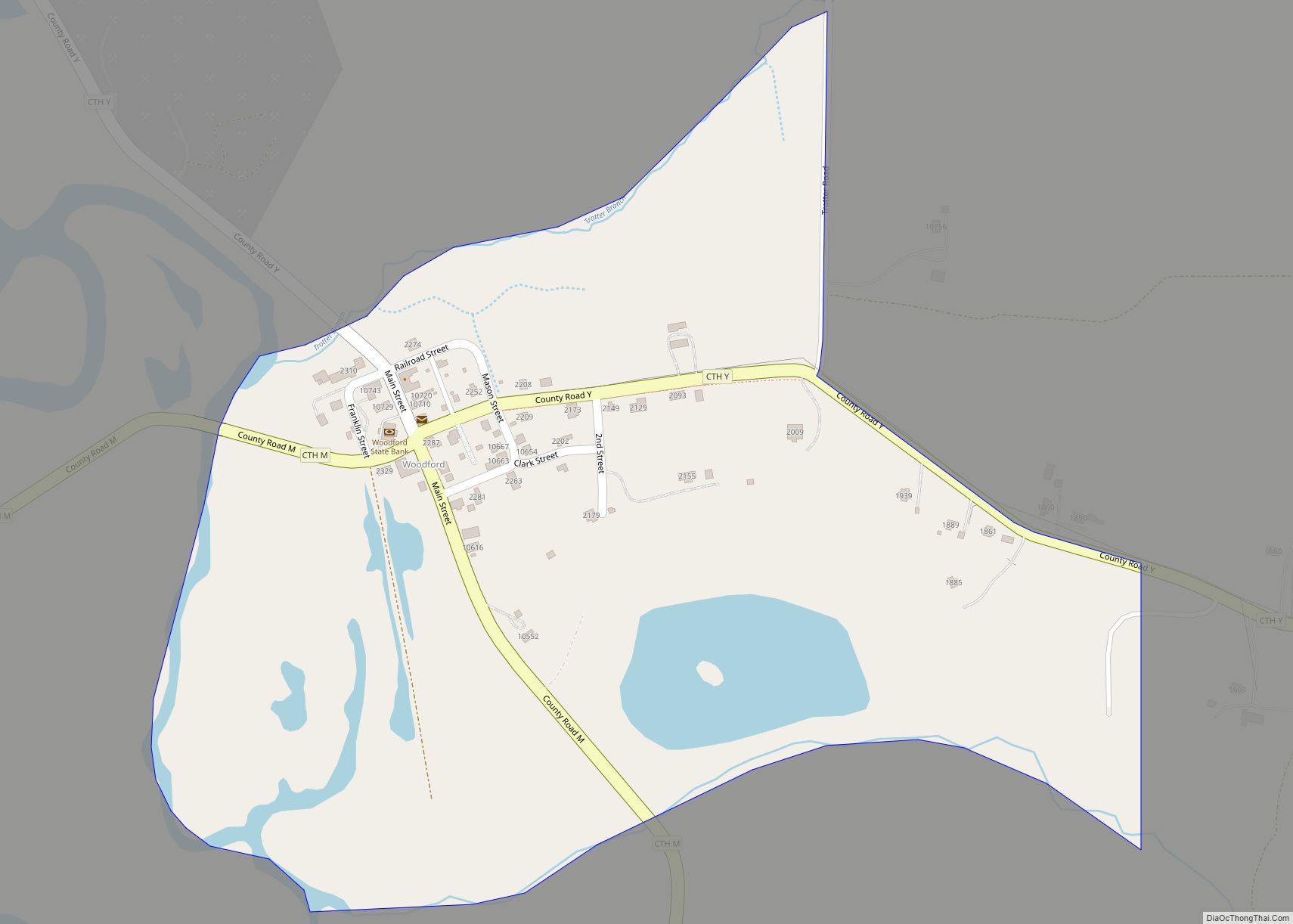
Map of Winneconne village
Winneconne is a town in Winnebago County, Wisconsin, United States. The population was 2,350 at the 2010 census. The Village of Winneconne is located within the town, on both sides of the Wolf River. The unincorporated community of Butte des Morts, named for a French and Native American trading war, is also located in the ... Read more
Map of Winneconne village
Map of Windsor village, Wisconsin
Windsor is a village and former town in Dane County, Wisconsin. The population was 8,754 at the time of the 2020 census. The communities of Lake Windsor, Morrisonville, and Token Creek are located within the village. Windsor voted to incorporate as a village on November 3, 2015; prior to its incorporation, it was a town, ... Read more
Map of Windsor village, Wisconsin
Map of Wind Point village
Wind Point is a village in Racine County, Wisconsin, United States. The population was 1,651 at the 2020 census. Wind Point village overview: Name: Wind Point village LSAD Code: 47 LSAD Description: village (suffix) State: Wisconsin County: Racine County Elevation: 614 ft (187 m) Total Area: 1.29 sq mi (3.34 km²) Land Area: 1.27 sq mi (3.28 km²) Water Area: 0.03 sq mi (0.07 km²) Total ... Read more
Map of Wind Point village
Map of Wind Lake CDP
Wind Lake is a census-designated place (CDP) in Racine County, Wisconsin, United States. The population was 5,355 at the 2020 census. Wind Lake is in the town of Norway. Wind Lake CDP overview: Name: Wind Lake CDP LSAD Code: 57 LSAD Description: CDP (suffix) State: Wisconsin County: Racine County Elevation: 794 ft (242 m) Total Area: 7.259 sq mi ... Read more
Map of Wind Lake CDP
Map of Zoar CDP, Wisconsin
Zoar (Menominee: Saqnawæpaniw) is a census-designated place (CDP) and unincorporated community in Menominee County, Wisconsin, United States. The population was 107 at the 2020 census. Zoar is located along Wisconsin Highway 47, approximately 3 miles (4.8 km) northwest of Neopit. Situated within traditional Menominee territory, it is known in the Menominee language as Saqnawehnaen, a name ... Read more
Map of Zoar CDP, Wisconsin
Map of Yuba village
Yuba is a village in Richland County, Wisconsin, United States. The population was 74 at the 2010 census. Yuba is 11 miles southwest of Hillsboro and 17 miles north of Richland Center. County Hwy C runs through the village. South of Yuba, looking north Inside St. Wenceslaus Church North of Yuba (population 77), looking south ... Read more
Map of Yuba village
Map of Yorkville village, Wisconsin
Yorkville is a village in Racine County, Wisconsin, United States. The population was 3,246 at the 2020 census. The unincorporated communities of Ives Grove, Sylvania, and Yorkville are located in the town. Yorkville village overview: Name: Yorkville village LSAD Code: 47 LSAD Description: village (suffix) State: Wisconsin County: Racine County Elevation: 709 ft (216 m) Total Area: ... Read more
Map of Yorkville village, Wisconsin
Map of Wyocena village
Wyocena is a town in Columbia County, Wisconsin, United States. The population was 619 at the 2000 Census. The Village of Wyocena is located within the town. Wyocena village overview: Name: Wyocena village LSAD Code: 47 LSAD Description: village (suffix) State: Wisconsin County: Columbia County FIPS code: 5589300 Online Interactive Map Wyocena online map. Source: ... Read more
Map of Wyocena village
Map of Wyeville village
Wyeville is a village in Monroe County, Wisconsin, United States. It is located on Wisconsin Highway 21. The population was 147 at the 2010 census. Wyeville village overview: Name: Wyeville village LSAD Code: 47 LSAD Description: village (suffix) State: Wisconsin County: Monroe County Elevation: 919 ft (280 m) Total Area: 0.56 sq mi (1.46 km²) Land Area: 0.56 sq mi (1.46 km²) Water ... Read more
Map of Wyeville village
Map of Abrams CDP
Abrams is an unincorporated community census-designated place located in the town of Abrams, Oconto County, Wisconsin, United States. Abrams is located near U.S. Route 41 and U.S. Route 141 8 miles (13 km) south-southeast of Oconto Falls. Abrams has a post office with ZIP code 54101. As of the 2020 census, its population was 358. Abrams ... Read more
Map of Abrams CDP
Map of Abbotsford city
Abbotsford is a city in Clark (mostly) and Marathon counties in the U.S. state of Wisconsin. The population was 2,275 at the 2020 census. Of this, 1,665 were in Clark County, and 610 were in Marathon County. Abbotsford is nicknamed “Wisconsin’s First City” due to its alphabetical place on a list of Wisconsin cities. Abbotsford ... Read more
Map of Abbotsford city
Map of Alma city, Wisconsin
Alma is a city in and the county seat of Buffalo County, Wisconsin, United States. The population was 716 at the 2020 census. The motto for the city of Alma is: “Step into Living History.” Alma city overview: Name: Alma city LSAD Code: 25 LSAD Description: city (suffix) State: Wisconsin County: Buffalo County Elevation: 673 ft ... Read more
Map of Alma city, Wisconsin