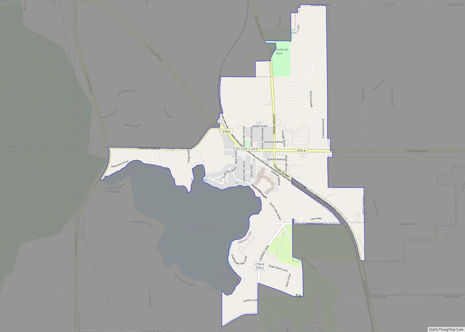
Map of Sister Bay village

Map of Sister Bay village

Sister Bay is a village in Door County, Wisconsin, United States. The population was 876 at the 2010 census. Sister Bay village overview: Name: Sister Bay village LSAD Code: 47 LSAD Description: village (suffix) State: Wisconsin County: Door County Elevation: 620 ft (189 m) Total Area: 3.57 sq mi (9.25 km²) Land Area: 2.58 sq mi (6.68 km²) Water Area: 0.99 sq mi (2.57 km²) Total … Read more

Map of Stoughton city

Map of Stoughton city

Stoughton is a city in Dane County, Wisconsin, United States. It straddles the Yahara River about 20 miles southeast of the state capital, Madison. Stoughton is part of the Madison Metropolitan Statistical Area. As of the 2020 census, the population was 13,173. Known for its Norwegian heritage, Stoughton hosts a citywide celebration of Syttende Mai, … Read more

Map of Stone Lake CDP

Map of Stone Lake CDP

Stone Lake is an unincorporated census-designated place in Sawyer and Washburn counties, Wisconsin, United States. Stone Lake is located on the eastern shore of Stone Lake and along Wisconsin Highway 70, 12 miles (19 km) west-northwest of Couderay. The Sawyer County portion of the community is located in the town of Sand Lake, while the Washburn … Read more

Map of Stoddard village

Map of Stoddard village

Stoddard is a village in Vernon County, Wisconsin, United States. The population was 840 at the 2020 census. Stoddard village overview: Name: Stoddard village LSAD Code: 47 LSAD Description: village (suffix) State: Wisconsin County: Vernon County Elevation: 659 ft (201 m) Total Area: 0.71 sq mi (1.84 km²) Land Area: 0.64 sq mi (1.65 km²) Water Area: 0.07 sq mi (0.19 km²) Total Population: 840 Population … Read more

Map of Stockholm village, Wisconsin

Map of Stockholm village, Wisconsin

Stockholm is a village in Pepin County, Wisconsin, United States, founded in 1854 by immigrants from Karlskoga, Sweden, who named it after their country’s capital. The population was 78 at the 2020 census. The village is located within the Town of Stockholm. Stockholm village overview: Name: Stockholm village LSAD Code: 47 LSAD Description: village (suffix) … Read more

Map of Stockbridge village, Wisconsin

Map of Stockbridge village, Wisconsin

Stockbridge is a town in Calumet County, Wisconsin. The population was 1,456 at the time of the 2010 census. The village of Stockbridge, and the unincorporated communities of Kloten, Quinney, and Saint Catherines Bay are located within the town. Stockbridge village overview: Name: Stockbridge village LSAD Code: 47 LSAD Description: village (suffix) State: Wisconsin County: … Read more

Map of Stevens Point city

Map of Stevens Point city

Stevens Point is the county seat of Portage County, Wisconsin, United States. The city was incorporated in 1858. Its 2020 population of 25,666 makes it the largest city in the county. Stevens Point forms the core of the United States Census Bureau’s Stevens Point Micropolitan Statistical Area, which had a 2020 population of 70,377 Stevens … Read more

Map of Steuben village

Map of Steuben village

Steuben is a village in Crawford County, Wisconsin, United States. The population was 131 at the 2010 census. Steuben village overview: Name: Steuben village LSAD Code: 47 LSAD Description: village (suffix) State: Wisconsin County: Crawford County Elevation: 676 ft (206 m) Total Area: 6.19 sq mi (16.04 km²) Land Area: 6.19 sq mi (16.04 km²) Water Area: 0.00 sq mi (0.00 km²) Total Population: 131 Population … Read more

Map of Stetsonville village

Map of Stetsonville village

Stetsonville is a village in Taylor County, Wisconsin, United States. The population was 541 at the 2010 census. Stetsonville village overview: Name: Stetsonville village LSAD Code: 47 LSAD Description: village (suffix) State: Wisconsin County: Taylor County Elevation: 1,453 ft (443 m) Total Area: 0.39 sq mi (1.01 km²) Land Area: 0.39 sq mi (1.01 km²) Water Area: 0.00 sq mi (0.00 km²) Total Population: 541 Population … Read more

Map of Star Prairie village

Map of Star Prairie village

Star Prairie is a town in St. Croix County, Wisconsin, United States. The population was 2,944 at the 2000 census. The Village of Star Prairie is located on the eastern boundary of the town. The unincorporated communities of Huntington and Johannesburg are located in the town. Star Prairie village overview: Name: Star Prairie village LSAD … Read more

Map of Stanley city, Wisconsin

Map of Stanley city, Wisconsin

Stanley is a city in Chippewa and Clark counties in the U.S. state of Wisconsin. The population was 3,608 at the 2010 census. Of this, 3,602 were in Chippewa County, and 6 in Clark County. Stanley city overview: Name: Stanley city LSAD Code: 25 LSAD Description: city (suffix) State: Wisconsin County: Chippewa County, Clark County … Read more

Map of Sullivan village, Wisconsin

Map of Sullivan village, Wisconsin

Sullivan is a town in Jefferson County, Wisconsin, United States. The population was 2,208 at the 2010 census. The village of Sullivan, the census-designated place of Rome, and the unincorporated communities of Heath Mills, Oak Hill, and Slabtown are located in the town. Sullivan village overview: Name: Sullivan village LSAD Code: 47 LSAD Description: village … Read more