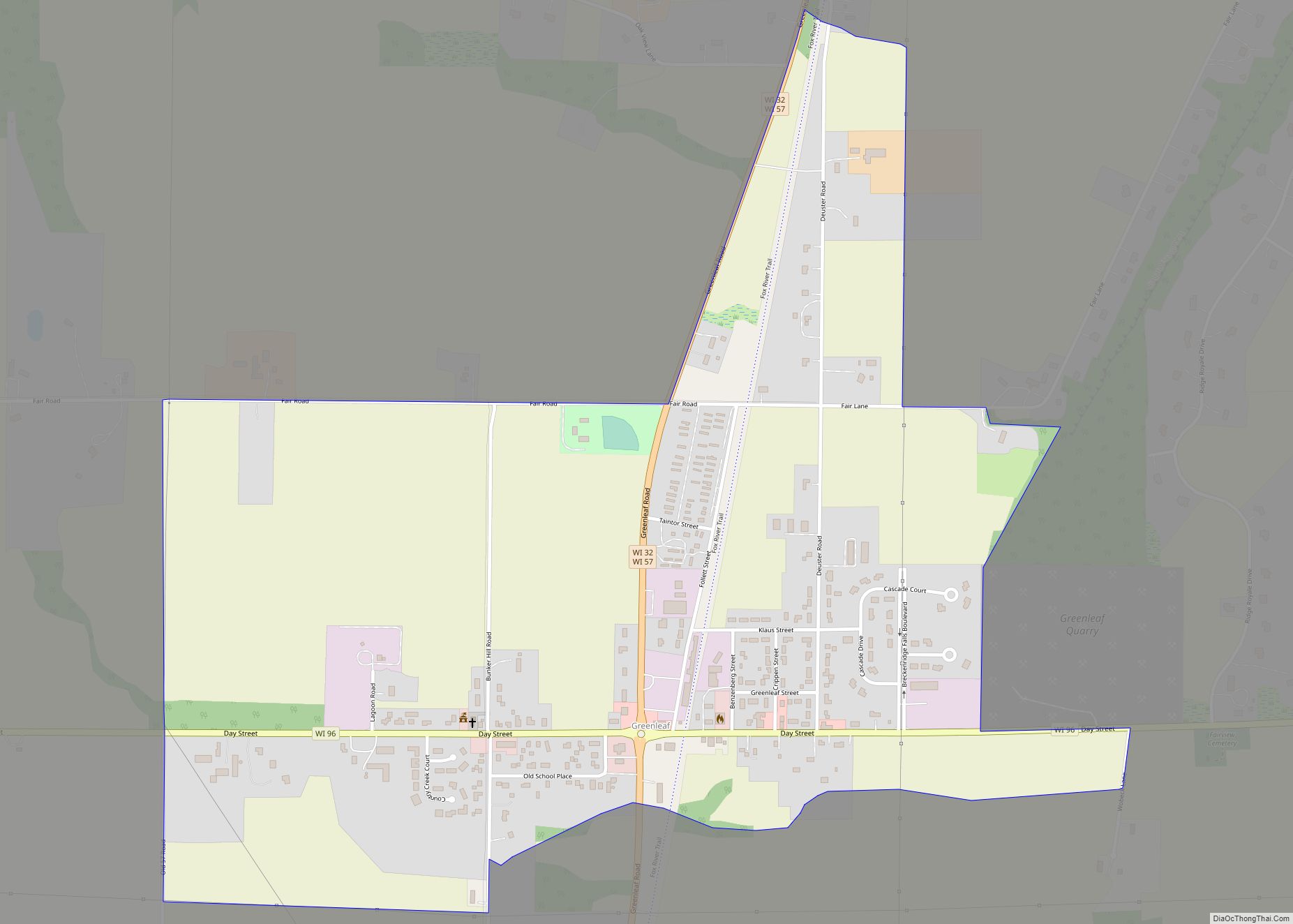
Map of Three Lakes CDP, Wisconsin

Map of Three Lakes CDP, Wisconsin

Three Lakes is an unincorporated census-designated place located in the town of Three Lakes, Oneida County, Wisconsin, United States. Three Lakes is located at the junction of U.S. Route 45 and Wisconsin Highway 32 9 miles (14 km) south-southeast of Eagle River. Three Lakes has a post office with ZIP code 54562. As of the 2010 … Read more

Map of Thorp city, Wisconsin

Map of Thorp city, Wisconsin

Thorp is a city in Clark County in the U.S. state of Wisconsin. The population was 1,621 at the 2010 census. The city is located partially within the Town of Thorp and partially within the Town of Withee. Thorp city overview: Name: Thorp city LSAD Code: 25 LSAD Description: city (suffix) State: Wisconsin County: Clark … Read more

Map of Thornton CDP, Wisconsin

Map of Thornton CDP, Wisconsin

Thornton is a census-designated place in the town of Richmond, Shawano County, Wisconsin, United States. Its population was 65 as of the 2010 census. Thornton CDP overview: Name: Thornton CDP LSAD Code: 57 LSAD Description: CDP (suffix) State: Wisconsin County: Shawano County Elevation: 853 ft (260 m) Total Area: 0.259 sq mi (0.67 km²) Land Area: 0.259 sq mi (0.67 km²) Water Area: … Read more

Map of Thiensville village

Map of Thiensville village

Thiensville is a village in Ozaukee County, Wisconsin, United States. Located on the west bank of a bend in the Milwaukee River, the community is bordered on all sides by the City of Mequon and is a suburb in the Milwaukee metropolitan area. The population was 3,235 at the 2010 census. Thiensville was the site … Read more

Map of Theresa village, Wisconsin

Map of Theresa village, Wisconsin

Theresa is a town in Dodge County, Wisconsin, United States. As of the census in 2000, the town population was 1,080. The Village of Theresa is located within the town. The unincorporated community of Theresa Station is located in the town. The unincorporated community of Hochheim is also located partially in the town. Theresa village … Read more

Map of Turtle Lake CDP, Wisconsin

Map of Turtle Lake CDP, Wisconsin

Turtle Lake is a census-designated place in the town of Richmond, Walworth County, Wisconsin, United States. Its population was 348 as of the 2020 census. Turtle Lake is 141 acres and has a maximum depth of 30 feet. Visitors have access to the lake from a public boat landing. Fish include panfish, largemouth bass, and … Read more

Map of Tunnel City CDP

Map of Tunnel City CDP

Tunnel City is an unincorporated census-designated place in the town of Greenfield, Monroe County, Wisconsin, United States, named after the train tunnel through a hill just to the west of town. Tunnel City CDP overview: Name: Tunnel City CDP LSAD Code: 57 LSAD Description: CDP (suffix) State: Wisconsin County: Monroe County Elevation: 320 m (1,060 ft) Total … Read more

Map of Waldo village, Wisconsin

Map of Waldo village, Wisconsin

Waldo is a village along the Onion River in Sheboygan County, Wisconsin, United States. The population was 503 at the 2010 census. It has a post office with ZIP code 53093. It is included in the Sheboygan, Wisconsin Metropolitan Statistical Area. Waldo village overview: Name: Waldo village LSAD Code: 47 LSAD Description: village (suffix) State: … Read more

Map of Trempealeau village

Map of Trempealeau village

Trempealeau is a village located along the Mississippi River in Trempealeau County in the U.S. state of Wisconsin. The population was 1,843 at the 2020 census. The village is surrounded by the Town of Trempealeau. Trempealeau village overview: Name: Trempealeau village LSAD Code: 47 LSAD Description: village (suffix) State: Wisconsin County: Trempealeau County Elevation: 738 ft … Read more

Map of Wabeno CDP

Map of Wabeno CDP

Wabeno is an unincorporated census-designated place located within the town of Wabeno, in Forest County, Wisconsin, United States. It is located on Wisconsin Highway 32 at the eastern terminus of Wisconsin Highway 52 within the Nicolet National Forest. As of the 2010 census, its population is 575. Wabeno CDP overview: Name: Wabeno CDP LSAD Code: … Read more

Map of Trego CDP, Wisconsin

Map of Trego CDP, Wisconsin

Trego (also Mills, Superior Junction) is an unincorporated census-designated place located in the town of Trego, Washburn County, Wisconsin, United States. Trego is located at the junction of U.S. Highway 53 and U.S. Highway 63, 6 miles (9.7 km) north-northeast of Spooner. Trego has a post office with ZIP code 54888. As of the 2010 census, … Read more

Map of Viroqua city

Map of Viroqua city

Viroqua is the county seat of Vernon County, Wisconsin, United States. The population was 4,504 at the 2020 census. The city is in the town of Viroqua. Viroqua city overview: Name: Viroqua city LSAD Code: 25 LSAD Description: city (suffix) State: Wisconsin County: Vernon County Total Area: 4.36 sq mi (11.29 km²) Land Area: 4.36 sq mi (11.29 km²) Water Area: … Read more