Map of Evanston city, Wyoming
Evanston is a city in and the county seat of Uinta County, Wyoming, United States. The population was 11,747 at the 2020 census. It is located near the border with Utah. Evanston city overview: Name: Evanston city LSAD Code: 25 LSAD Description: city (suffix) State: Wyoming County: Uinta County Elevation: 6,749 ft (2,057 m) Total Area: 10.33 sq mi ... Read more
Map of Evanston city, Wyoming
Map of Ethete CDP
Ethete (Arapaho: Koonoutoseii’) is a census-designated place (CDP) in Fremont County, Wyoming, United States. The population was 1,553 at the 2010 census. The town is located on the Wind River Indian Reservation. It grew up around the Episcopal St. Michael’s Mission. Ethete CDP overview: Name: Ethete CDP LSAD Code: 57 LSAD Description: CDP (suffix) State: ... Read more
Map of Ethete CDP
Map of Glendo town
Glendo is a town in Platte County, Wyoming, United States. The population was 205 at the 2010 census. Glendo town overview: Name: Glendo town LSAD Code: 43 LSAD Description: town (suffix) State: Wyoming County: Platte County Elevation: 4,724 ft (1,440 m) Total Area: 0.59 sq mi (1.53 km²) Land Area: 0.59 sq mi (1.53 km²) Water Area: 0.00 sq mi (0.00 km²) Total Population: 205 Population ... Read more
Map of Glendo town
Map of Encampment town
Encampment (also known as Grand Encampment) is a town in southern Carbon County, Wyoming, United States. The population was 450 at the 2010 census. Encampment town overview: Name: Encampment town LSAD Code: 43 LSAD Description: town (suffix) State: Wyoming County: Carbon County Elevation: 7,277 ft (2,218 m) Total Area: 1.60 sq mi (4.14 km²) Land Area: 1.60 sq mi (4.14 km²) Water Area: ... Read more
Map of Encampment town
Map of Freedom CDP, Wyoming
Freedom is an unincorporated community in both northeastern Caribou County, Idaho, and northwestern Lincoln County, Wyoming, in the United States; the Wyoming portion of the community is also a census-designated place (CDP). The population was 214 at the 2010 census. Freedom CDP overview: Name: Freedom CDP LSAD Code: 57 LSAD Description: CDP (suffix) State: Wyoming ... Read more
Map of Freedom CDP, Wyoming
Map of Elk Mountain town
Elk Mountain is a town in Carbon County, Wyoming, United States. The population was 150 at the 2020 census. The town shares its name with a mountain 7 miles (11 km) to its southwest. Elk Mountain town overview: Name: Elk Mountain town LSAD Code: 43 LSAD Description: town (suffix) State: Wyoming County: Carbon County Elevation: 7,264 ft ... Read more
Map of Elk Mountain town
Map of Edgerton town, Wyoming
Edgerton is a town in Natrona County, Wyoming, United States. It is part of the Casper, Wyoming Metropolitan Statistical Area. The population was 195 at the 2010 census. Edgerton town overview: Name: Edgerton town LSAD Code: 43 LSAD Description: town (suffix) State: Wyoming County: Natrona County Elevation: 4,898 ft (1,493 m) Total Area: 0.30 sq mi (0.77 km²) Land Area: ... Read more
Map of Edgerton town, Wyoming
Map of Fox Farm-College CDP
Fox Farm-College is a census-designated place (CDP) in Laramie County, Wyoming, United States. It is part of the Cheyenne, Wyoming Metropolitan Statistical Area. The population was 3,876 people at the 2020 census. Fox Farm-College CDP overview: Name: Fox Farm-College CDP LSAD Code: 57 LSAD Description: CDP (suffix) State: Wyoming County: Laramie County Total Area: 3.5 sq mi ... Read more
Map of Fox Farm-College CDP
Map of Fort Laramie town
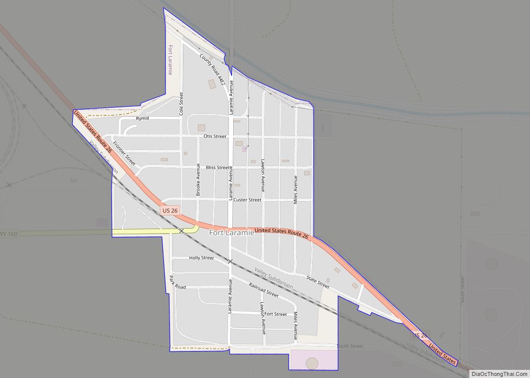
Fort Laramie is a town in Goshen County, Wyoming, United States. The population was 230 at the 2010 census. The town is named after historic Fort Laramie, an important stop on the Oregon, California and Mormon trails, as well as a staging point for various military excursions and treaty signings. The old fort was located ... Read more
Map of Fort Laramie town
Map of Fort Bridger CDP
Fort Bridger is a census-designated place (CDP) in eastern Uinta County, Wyoming, United States. The population was 345 at the 2010 census. The community takes its name from the eponymous Fort Bridger, established in 1842, which is located within the boundaries of the CDP. Fort Bridger CDP overview: Name: Fort Bridger CDP LSAD Code: 57 ... Read more
Map of Fort Bridger CDP
Map of Hanna town, Wyoming
Hanna is a town in Carbon County, Wyoming, United States. The population was 683 at the 2020 census. The town was started as a coal supply location for the Union Pacific Railroad. Much of the old town is built on top of the former workings of the Hanna No. 4 mine. On December 18, 1979, the ... Read more
Map of Hanna town, Wyoming
Map of Guernsey town, Wyoming
Guernsey is a town in Platte County, Wyoming, United States. The population was 1,147 at the 2010 census. The town was named for C. A. Guernsey, a cattle rancher. Guernsey town overview: Name: Guernsey town LSAD Code: 43 LSAD Description: town (suffix) State: Wyoming County: Platte County Elevation: 4,354 ft (1,327 m) Total Area: 1.04 sq mi (2.69 km²) Land ... Read more
Map of Guernsey town, Wyoming