Map of Lusk town
Lusk is a high-plains town in the eastern part of the U.S. state of Wyoming. The town is the seat of Niobrara County. The town was founded in July 1886, by Frank S. Lusk, a renowned Wyoming rancher, partner in the Western Live Stock Company, and stockholder in the Wyoming Central Railway. Cattle ranching remains ... Read more
Map of Lusk town
Map of Lucerne CDP, Wyoming
Lucerne is a census-designated place (CDP) in Hot Springs County, Wyoming, United States. The population was 535 at the 2010 census. Lucerne CDP overview: Name: Lucerne CDP LSAD Code: 57 LSAD Description: CDP (suffix) State: Wyoming County: Hot Springs County Elevation: 4,315 ft (1,315 m) Total Area: 20.6 sq mi (53 km²) Land Area: 19.9 sq mi (52 km²) Water Area: 0.7 sq mi (2 km²) ... Read more
Map of Lucerne CDP, Wyoming
Map of Lovell town
Lovell is the largest town in Big Horn County, Wyoming, United States. The population was 2,360 at the 2010 census. Lovell town overview: Name: Lovell town LSAD Code: 43 LSAD Description: town (suffix) State: Wyoming County: Big Horn County Elevation: 3,832 ft (1,168 m) Total Area: 1.10 sq mi (2.85 km²) Land Area: 1.10 sq mi (2.85 km²) Water Area: 0.00 sq mi (0.00 km²) Total ... Read more
Map of Lovell town
Map of Lonetree CDP
Lonetree is a census-designated place (CDP) in Uinta County, Wyoming, United States. The population was 49 at the 2010 census. Lonetree CDP overview: Name: Lonetree CDP LSAD Code: 57 LSAD Description: CDP (suffix) State: Wyoming County: Uinta County Elevation: 7,556 ft (2,303 m) Total Area: 45.6 sq mi (118.2 km²) Land Area: 45.6 sq mi (118.1 km²) Water Area: 0.0 sq mi (0.1 km²) Total Population: ... Read more
Map of Lonetree CDP
Map of Little America CDP
Little America is a census-designated place (CDP) in Sweetwater County, Wyoming, United States. The population was 68 at the 2010 census. The community got its name from the Little America motel, which was purposefully located in a remote location as a haven, not unlike the Little America base camp the polar explorer Richard E. Byrd ... Read more
Map of Little America CDP
Map of Lingle town
Lingle is a town in Goshen County, Wyoming, United States. The population was 468 at the 2010 census. Former Wyoming Supreme Court Justice Richard V. Thomas was reared in Lingle. Lingle town overview: Name: Lingle town LSAD Code: 43 LSAD Description: town (suffix) State: Wyoming County: Goshen County Elevation: 4,173 ft (1,272 m) Total Area: 0.31 sq mi (0.81 km²) ... Read more
Map of Lingle town
Map of Lander city
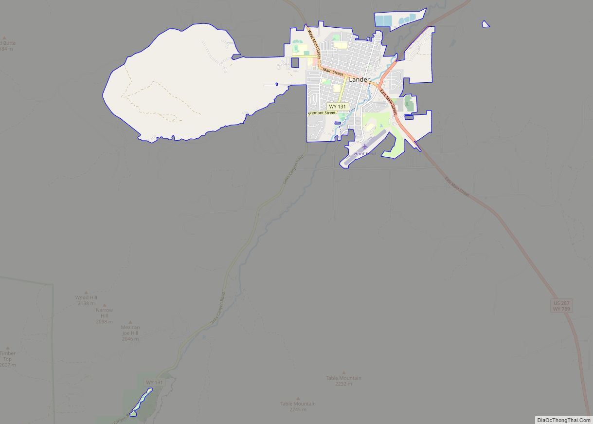
Lander is a city in Wyoming, United States, and the county seat of Fremont County. It is in central Wyoming, along the Middle Fork of the Popo Agie River, just south of the Wind River Indian Reservation. It is a tourism center with several nearby guest ranches. Its population was 7,487 at the 2010 census. ... Read more
Map of Lander city
Map of Lance Creek CDP
Lance Creek is a census-designated place (CDP) in Niobrara County, Wyoming, United States. The population was 43 at the 2010 census. Lance Creek is the namesake of the Lance Formation, a rock formation from the Late Cretaceous that has yielded fossils from a diverse number of species. Lance Creek CDP overview: Name: Lance Creek CDP ... Read more
Map of Lance Creek CDP
Map of Lakeview North CDP
Lakeview North is a census-designated place (CDP) in Platte County, Wyoming, United States. The population was 84 at the 2010 census. Lakeview North CDP overview: Name: Lakeview North CDP LSAD Code: 57 LSAD Description: CDP (suffix) State: Wyoming County: Platte County Total Area: 0.9 sq mi (2.2 km²) Land Area: 0.9 sq mi (2.2 km²) Water Area: 0.0 sq mi (0.0 km²) Total Population: ... Read more
Map of Lakeview North CDP
Map of La Grange town, Wyoming
LaGrange is a town in Goshen County, Wyoming, United States. The population was 448 at the time of the 2010 census. La Grange town overview: Name: La Grange town LSAD Code: 43 LSAD Description: town (suffix) State: Wyoming County: Goshen County Elevation: 4,590 ft (1,399 m) Total Area: 0.39 sq mi (1.00 km²) Land Area: 0.39 sq mi (1.00 km²) Water Area: 0.00 sq mi ... Read more
Map of La Grange town, Wyoming
Map of Marbleton town
Marbleton is a town in Sublette County, Wyoming, United States. The population was 1,094 at the 2010 census. Marbleton town overview: Name: Marbleton town LSAD Code: 43 LSAD Description: town (suffix) State: Wyoming County: Sublette County Elevation: 6,867 ft (2,093 m) Total Area: 0.91 sq mi (2.35 km²) Land Area: 0.91 sq mi (2.35 km²) Water Area: 0.00 sq mi (0.00 km²) Total Population: 1,094 Population ... Read more
Map of Marbleton town
Map of Manville town, Wyoming
Manville is a town in Niobrara County, Wyoming, United States. The population was 95 at the 2010 census. Manville town overview: Name: Manville town LSAD Code: 43 LSAD Description: town (suffix) State: Wyoming County: Niobrara County Elevation: 5,253 ft (1,601 m) Total Area: 0.27 sq mi (0.70 km²) Land Area: 0.27 sq mi (0.70 km²) Water Area: 0.00 sq mi (0.00 km²) Total Population: 95 Population ... Read more
Map of Manville town, Wyoming