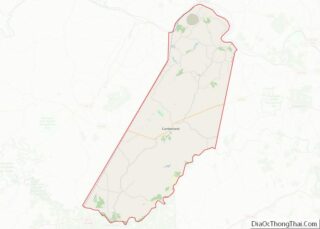
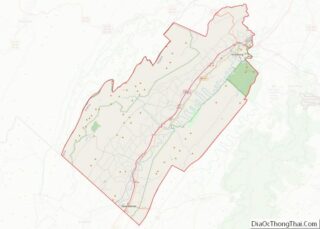
Map of Dodge County

Map of Dodge County, Wisconsin

Dodge County is a county located in the U.S. state of Wisconsin. As of the 2020 census, the population was 89,396. Its county seat is Juneau. The county was created from the Wisconsin Territory in 1836 and organized in 1844. Dodge County comprises the Beaver Dam, WI Micropolitan Statistical Area, which is included in the … Read more

Map of Kenosha County

Map of Kenosha County, Wisconsin

Kenosha County is located in the southeastern corner of the U.S. state of Wisconsin. The population was 169,151 as of the 2020 census, making it the eighth most populous county in Wisconsin. The county shares the same name as the city of Kenosha, the fourth largest city in Wisconsin. Kenosha County is part of the … Read more

Map of Oneida County

Map of Oneida County, Wisconsin

Oneida County is a county in the state of Wisconsin, United States. At the 2020 census, the population was 37,845. Its county seat is Rhinelander. Oneida County overview: Name: Oneida County FIPS code: 55-085 State: Wisconsin Founded: 1887 Named for: Oneida people Seat: Rhinelander Largest city: Rhinelander Total Area: 1,236 sq mi (3,200 km²) Land Area: 1,113 sq mi (2,880 km²) … Read more

Map of Sheboygan County

Map of Sheboygan County, Wisconsin

Sheboygan County is a county in the U.S. state of Wisconsin. It is named after the Sheboygan River. As of the 2020 census, the population was 118,034. Its county seat is Sheboygan. The county was created in 1836 and organized in 1846. At the time, it was located in the Wisconsin Territory. Sheboygan County comprises … Read more

Map of Carbon County

Map of Carbon County, Wyoming

Carbon County overview: Name: Carbon County FIPS code: 56-007 State: Wyoming Founded: December 16, 1868 Named for: Coal deposits Seat: Rawlins Largest city: Rawlins Total Area: 7,964 sq mi (20,630 km²) Land Area: 7,898 sq mi (20,460 km²) Total Population: 14,537 Population Density: 1.8/sq mi (0.70/km²) Carbon County location map. Where is Carbon County? History Carbon County was organized in 1868, one … Read more

Map of Teton County

Map of Teton County, Wyoming

Teton County is a county in the U.S. state of Wyoming. As of the 2020 United States Census, the population was 23,331. Its county seat is Jackson. Its west boundary line is also the Wyoming state boundary shared with Idaho and the southern tip of Montana. Teton County is part of the Jackson, WY-ID Micropolitan … Read more

Map of Chambers County

Map of Chambers County, Alabama

Chambers County is a county located in the east central portion of the U.S. state of Alabama. As of the 2020 census the population was 34,772. Its county seat is LaFayette. Its largest city is Valley. Its name is in honor of Henry H. Chambers, who served as a United States Senator from Alabama. Chambers … Read more

Map of De Kalb County

Map of DeKalb County, Alabama

DeKalb County is a county located in the northeastern part of the U.S. state of Alabama. As of the 2020 census, the population was 71,608. Its county seat is Fort Payne, and it is named after Major General Baron Johan DeKalb. DeKalb County is part of the Huntsville-Decatur-Albertville, AL Combined Statistical Area. DeKalb County overview: … Read more

Map of Lee County

Map of Lee County, Alabama

Lee County is a county located in east central Alabama. As of the 2020 census the population was 174,241. The county seat is Opelika, and the largest city is Auburn. The county was established in 1866 and is named for General Robert E. Lee (1807–1870), who served as General in Chief of the Armies of … Read more

Map of Russell County

Map of Russell County, Alabama

Russell County is a county in the southeastern part of the U.S. state of Alabama. As of the 2020 census, the population was 59,183. Its county seat is Phenix City. Its name is in honor of Colonel Gilbert C. Russell, who fought in the wars against the Creek Indians. Russell County is part of the … Read more

Map of Denali Borough

Map of Denali Borough, Alaska

The Denali Borough is a borough located in the U.S. state of Alaska. As of the 2020 census the population of the borough was 1,619, down from 1,826 in 2010. The borough seat and most populated community is Healy, and its only incorporated place is Anderson. The borough was incorporated in December 1990. The area … Read more

Map of Southeast Fairbanks Census Area

Map of Southeast Fairbanks Census Area, Alaska

Southeast Fairbanks Census Area is a census area located in the U.S. state of Alaska. As of the 2020 census, the population was 6,808, down from 7,029 in 2010. It is part of the unorganized borough and therefore has no borough seat. Its largest communities are Deltana and Tok, both unincorporated CDPs. Southeast Fairbanks Census … Read more