Map of Frisco City town

Map of Frisco City town

Frisco City is a town in Monroe County, Alabama, United States. At the 2020 census, the population was 1,170. Frisco City town overview: Name: Frisco City town LSAD Code: 43 LSAD Description: town (suffix) State: Alabama County: Monroe County Elevation: 404 ft (123 m) Total Area: 4.04 sq mi (10.46 km²) Land Area: 4.03 sq mi (10.43 km²) Water Area: 0.01 sq mi (0.02 km²) Total … Read more

Map of Fredonia CDP

Map of Fredonia CDP, Alabama

Fredonia /friˈdoʊniə/ free-DOH-nia is an unincorporated community and census-designated place in Chambers County, Alabama, United States. Its elevation is 794 feet (242 m), and it is located at 32°59′23″N 85°17′19″W / 32.98972°N 85.28861°W / 32.98972; -85.28861 (32.9898462, -85.2885564). As of the 2010 census, its population was 199. Other names for the community have included “Freedona” and … Read more

Map of Franklin town

Map of Franklin town, Alabama

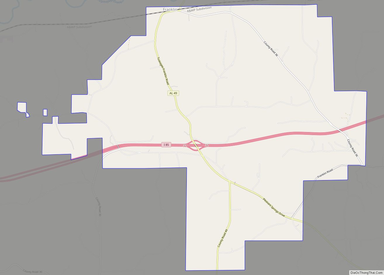
Franklin is a rural town in Macon County, Alabama, United States. As of the 2020 census, the population was 590. Franklin town overview: Name: Franklin town LSAD Code: 43 LSAD Description: town (suffix) State: Alabama County: Macon County Elevation: 220 ft (70 m) Total Area: 15.11 sq mi (39.14 km²) Land Area: 15.07 sq mi (39.04 km²) Water Area: 0.04 sq mi (0.10 km²) Total Population: … Read more

Map of Fulton town

Map of Fulton town, Alabama

Fulton is a town in Clarke County, Alabama, United States. At the 2020 census, the population was 223. Fulton town overview: Name: Fulton town LSAD Code: 43 LSAD Description: town (suffix) State: Alabama County: Clarke County Elevation: 240 ft (73 m) Total Area: 2.45 sq mi (6.35 km²) Land Area: 2.45 sq mi (6.35 km²) Water Area: 0.00 sq mi (0.00 km²) Total Population: 223 Population … Read more

Map of Fruithurst town

Map of Fruithurst town

Fruithurst is a town in Cleburne County, Alabama, United States. At the 2020 census, the population was 235. Fruithurst town overview: Name: Fruithurst town LSAD Code: 43 LSAD Description: town (suffix) State: Alabama County: Cleburne County Elevation: 1,079 ft (329 m) Total Area: 1.00 sq mi (2.59 km²) Land Area: 1.00 sq mi (2.59 km²) Water Area: 0.00 sq mi (0.00 km²) Total Population: 235 Population … Read more

Map of Fruitdale CDP

Map of Fruitdale CDP, Alabama

Fruitdale is a census-designated place and unincorporated community in Washington County, Alabama, United States. Its population was 185 as of the 2010 census. Fruitdale High School serves K-12 students in the area. In November 2022, The town was struck by an EF-3 Tornado. Fruitdale CDP overview: Name: Fruitdale CDP LSAD Code: 57 LSAD Description: CDP … Read more

Map of Gadsden city

Map of Gadsden city, Alabama

Gadsden is a city in and the county seat of Etowah County in the U.S. state of Alabama. It is located on the Coosa River about 56 miles (90 km) northeast of Birmingham and 90 miles (140 km) southwest of Chattanooga, Tennessee. It is the primary city of the Gadsden Metropolitan Statistical Area, which has a population … Read more

Map of Fyffe town

Map of Fyffe town

Fyffe is a town in DeKalb County, Alabama, United States. It was incorporated in 1956. At the 2020 census, the population was 967. Fyffe is located atop Sand Mountain. Fyffe town overview: Name: Fyffe town LSAD Code: 43 LSAD Description: town (suffix) State: Alabama County: DeKalb County Elevation: 1,280 ft (390 m) Total Area: 4.97 sq mi (12.87 km²) Land … Read more

Map of Fultondale city

Map of Fultondale city

Fultondale is a city in Jefferson County, Alabama, United States and a northern suburb of Birmingham. As of the 2010 census, the population of the city is 8,380. Fultondale city overview: Name: Fultondale city LSAD Code: 25 LSAD Description: city (suffix) State: Alabama County: Jefferson County Elevation: 505 ft (154 m) Total Area: 12.14 sq mi (31.43 km²) Land Area: … Read more

Map of Gantt town

Map of Gantt town, Alabama

Gantt is a town in Covington County, Alabama, United States. At the 2020 census, the population was 196. Gantt town overview: Name: Gantt town LSAD Code: 43 LSAD Description: town (suffix) State: Alabama County: Covington County Elevation: 233 ft (71 m) Total Area: 0.68 sq mi (1.77 km²) Land Area: 0.65 sq mi (1.68 km²) Water Area: 0.03 sq mi (0.09 km²) Total Population: 196 Population … Read more

Map of Gallant CDP

Map of Gallant CDP

Gallant, also known as Clear Springs or Greasy Cove, is a census-designated place and unincorporated community in Etowah, and St. Clair counties, Alabama, United States. It lies west of the city of Gadsden, the county seat of Etowah County. As of the 2010 census, its population was 855. It has a post office with the … Read more

Map of Gainesville city

Map of Gainesville town, Alabama

Gainesville is a town in Sumter County, Alabama, United States. Founded in 1832, it was incorporated in 1835. At the 2010 census the population was 208, down from 220. Confederate Lieutenant General Nathan Bedford Forrest surrendered his men near Gainesville on May 19, 1865, at the Civil War’s end. Gainesville town overview: Name: Gainesville town … Read more