Map of Somerville town

Map of Somerville town, Alabama

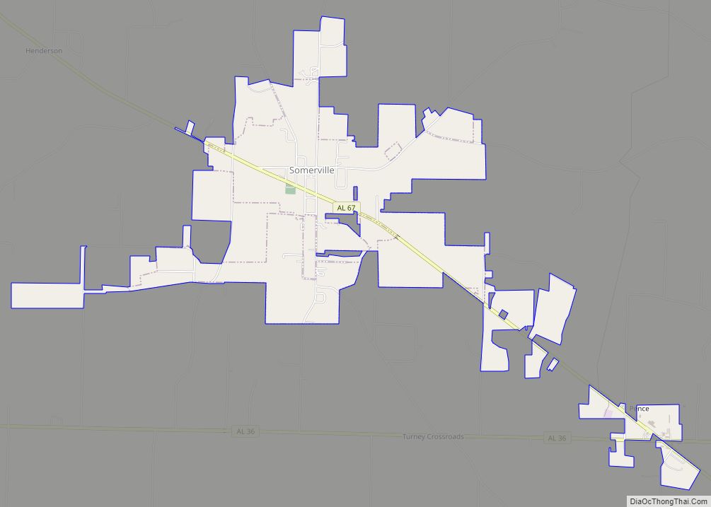
Somerville is a town in Morgan County, Alabama, United States. It is included in the Decatur Metropolitan Area and the Huntsville-Decatur Combined Statistical Area. As of the 2020 census, the population of the town was 796. Somerville town overview: Name: Somerville town LSAD Code: 43 LSAD Description: town (suffix) State: Alabama County: Morgan County Incorporated: … Read more

Map of Snead town

Map of Snead town

Snead is a town in Blount County, Alabama, United States. At the 2020 census, the population was 1,032. Snead town overview: Name: Snead town LSAD Code: 43 LSAD Description: town (suffix) State: Alabama County: Blount County Elevation: 791 ft (241 m) Total Area: 5.54 sq mi (14.34 km²) Land Area: 5.52 sq mi (14.30 km²) Water Area: 0.02 sq mi (0.05 km²) Total Population: 1,032 Population … Read more

Map of Smoke Rise CDP

Map of Smoke Rise CDP

Smoke Rise is a census-designated place (CDP) in Blount County, Alabama, United States. At the 2020 census, the population was 1,661. Smoke Rise CDP overview: Name: Smoke Rise CDP LSAD Code: 57 LSAD Description: CDP (suffix) State: Alabama County: Blount County Elevation: 1,030 ft (314 m) Total Area: 5.82 sq mi (15.06 km²) Land Area: 5.80 sq mi (15.03 km²) Water Area: 0.01 sq mi … Read more

Map of Southside city

Map of Southside city, Alabama

Southside is a city located in Etowah County in the U.S. state of Alabama. It is included in the Gadsden Metropolitan Statistical Area. It incorporated in 1957. The population was 8,412 at the time of the 2010 United States Census. Located 8 to 12 miles (13 to 19 km) south of downtown Gadsden, Southside is one … Read more

Map of South Vinemont town

Map of South Vinemont town

South Vinemont is a town in Cullman County, Alabama, United States. At the 2010 census the population was 749, up from 425 in 2000. Initially incorporated as the town of Vinemont in 1961, state officials informed them the name was already taken and so was later changed to South Vinemont. However, the U.S. Census still … Read more

Map of Spanish Fort city

Map of Spanish Fort city

Spanish Fort is a city in Baldwin County, Alabama, United States, located on the eastern shore of Mobile Bay. The 2020 census lists the population of the city as 10,049. It is a suburb of Mobile and is part of the Daphne-Fairhope-Foley metropolitan area. Spanish Fort city overview: Name: Spanish Fort city LSAD Code: 25 … Read more

Map of Spruce Pine CDP

Map of Spruce Pine CDP, Alabama

Spruce Pine is a census-designated place and unincorporated community in Franklin County, Alabama, United States. Its population was 222 as of the 2010 census. Spruce Pine CDP overview: Name: Spruce Pine CDP LSAD Code: 57 LSAD Description: CDP (suffix) State: Alabama County: Franklin County Elevation: 1,027 ft (313 m) Total Area: 0.93 sq mi (2.41 km²) Land Area: 0.93 sq mi (2.40 km²) … Read more

Map of Springville city

Map of Springville city, Alabama

Springville is a city in St. Clair County, Alabama, United States. It incorporated in December 1880. At the 2020 census the population was 4,786, up from 4,080 in 2010. Springville city overview: Name: Springville city LSAD Code: 25 LSAD Description: city (suffix) State: Alabama County: St. Clair County Incorporated: December 1880 Elevation: 725 ft (221 m) Total … Read more

Map of Spring Garden CDP

Map of Spring Garden CDP, Alabama

Spring Garden is a census-designated place and unincorporated community in Cherokee County, Alabama, United States. Its population was 216 as of the 2020 census. The area was also known as Amberson or Ambersonville in the 19th century. It was erroneously called “Aubersonville” in the 1880 U.S. Census. Spring Garden CDP overview: Name: Spring Garden CDP … Read more

Map of Standing Rock CDP

Map of Standing Rock CDP

Standing Rock is a census-designated place and unincorporated community in Chambers County, Alabama, United States. Its population was 132 as of the 2020 census. Standing Rock CDP overview: Name: Standing Rock CDP LSAD Code: 57 LSAD Description: CDP (suffix) State: Alabama County: Chambers County Elevation: 794 ft (242 m) Total Area: 3.23 sq mi (8.36 km²) Land Area: 3.19 sq mi (8.26 km²) … Read more

Map of St. Stephens CDP

Map of St. Stephens CDP, Alabama

St. Stephens is an unincorporated census-designated place in Washington County, Alabama, United States. Its population is 580. Located near the Tombigbee River in the southwestern part of the state and 67 miles north of Mobile, it is composed of two distinct sites: Old St. Stephens and New St. Stephens. The Old St. Stephens site lies … Read more

Map of St. Florian town

Map of St. Florian town

St. Florian is a town in Lauderdale County, Alabama, United States. It is part of the Florence – Muscle Shoals Metropolitan Statistical Area known as “The Shoals”. As of the 2010 census, the population of the town is 413, up from 335 in 2000. St. Florian town overview: Name: St. Florian town LSAD Code: 43 … Read more