Map of Paris city

Map of Paris city, Arkansas

Paris is a city in Logan County, Arkansas, United States, and serves as the county seat for the northern district of Logan County; its southern district counterpart is Booneville. Its population was 3,176 as of the 2020 U.S. Census. Paris city overview: Name: Paris city LSAD Code: 25 LSAD Description: city (suffix) State: Arkansas County: … Read more

Map of Paragould city

Map of Paragould city

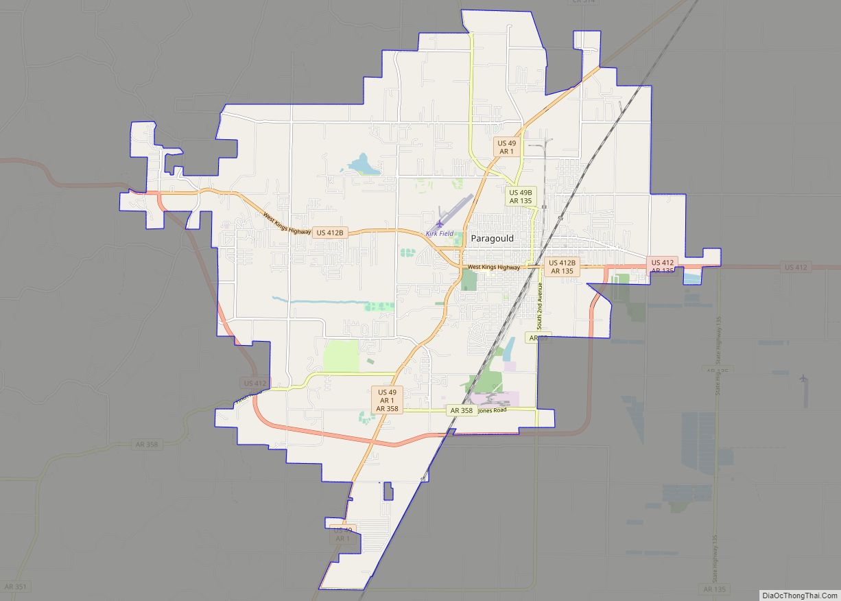
Paragould is the county seat of Greene County, and the 19th-largest city in Arkansas, in the United States. The city is located in northeastern Arkansas on the eastern edge of Crowley’s Ridge, a geologic anomaly contained within the Arkansas delta. Paragould is the principal city of the Paragould, Arkansas Micropolitan Statistical Area and is also … Read more

Map of Patterson city

Map of Patterson city, Arkansas

Patterson is a city in Woodruff County, Arkansas, United States. The population was 452 at the 2010 census. Patterson city overview: Name: Patterson city LSAD Code: 25 LSAD Description: city (suffix) State: Arkansas County: Woodruff County Elevation: 200 ft (61 m) Total Area: 1.13 sq mi (2.93 km²) Land Area: 1.13 sq mi (2.93 km²) Water Area: 0.00 sq mi (0.00 km²) Total Population: 310 Population … Read more

Map of Patmos town

Map of Patmos town

Patmos is a town in Hempstead County, Arkansas, United States. The population was 64 at the 2010 census. It bears the same name as the Greek island of Patmos, where the Book of Revelation was written. Patmos is part of the Hope Micropolitan Statistical Area. Patmos town overview: Name: Patmos town LSAD Code: 43 LSAD … Read more

Map of Parkin city

Map of Parkin city

Parkin is a city in Cross County, Arkansas, United States, along the St. Francis River. The population was 1,105 at the 2010 census, down from 1,602 in 2000. Due to the recent population loss, a large segment of the downtown area has many abandoned and boarded-up buildings. The town has recently become known as a … Read more

Map of Perla town

Map of Perla town

Perla is a town in Hot Spring County, Arkansas, United States. The population was 241 at the 2010 census, up from 115 at the 2000 census. The city’s water association filed for Chapter 9 Bankruptcy in the Western District of Arkansas Bankruptcy Court on May 26, 2019. Perla town overview: Name: Perla town LSAD Code: … Read more

Map of Peach Orchard city

Map of Peach Orchard city

Peach Orchard is a city in Clay County, Arkansas, United States. The population was 135 at the 2010 census. Peach Orchard city overview: Name: Peach Orchard city LSAD Code: 25 LSAD Description: city (suffix) State: Arkansas County: Clay County Elevation: 285 ft (87 m) Total Area: 1.03 sq mi (2.67 km²) Land Area: 1.03 sq mi (2.67 km²) Water Area: 0.00 sq mi (0.00 km²) Total … Read more

Map of Pea Ridge city

Map of Pea Ridge city, Arkansas

Pea Ridge is a city in Benton County, Arkansas, United States. The name Pea Ridge is derived from a combination of the physical location of the original settlement of the town, across the crest of an Ozark Mountains ridge, and for the hog peanuts or turkey peas that had been originally cultivated by Native American … Read more

Map of Perrytown town

Map of Perrytown town

Perrytown is a town in Hempstead County, Arkansas, United States. The population was 272 at the 2010 census. It is part of the Hope Micropolitan Statistical Area and was founded in 1959 by local entrepreneur Perry Campbell. Perrytown town overview: Name: Perrytown town LSAD Code: 43 LSAD Description: town (suffix) State: Arkansas County: Hempstead County … Read more

Map of Perry town

Map of Perry town, Arkansas

Perry is a town in Perry County, Arkansas, United States. The population was 314 at the 2000 census. It is part of the Little Rock–North Little Rock–Conway Metropolitan Statistical Area. Perry town overview: Name: Perry town LSAD Code: 43 LSAD Description: town (suffix) State: Arkansas County: Perry County Elevation: 361 ft (110 m) Total Area: 0.70 sq mi (1.82 km²) … Read more

Map of Perryville city, Arkansas

Map of Perryville city, Arkansas

Perryville is a city in and the county seat of Perry County, Arkansas, United States. The population was 1,460 at the 2010 census, an increase of just two persons from 2000. It is part of the Little Rock–North Little Rock–Conway Metropolitan Statistical Area. Perryville city overview: Name: Perryville city LSAD Code: 25 LSAD Description: city … Read more

Map of Pine Bluff city

Map of Pine Bluff city

Pine Bluff is the eleventh-largest city in the state of Arkansas and the county seat of Jefferson County. It is the principal city of the Pine Bluff Metropolitan Statistical Area and part of the Little Rock–North Little Rock-Pine Bluff Combined Statistical Area. The population of the city was 49,083 in the 2010 Census with 2019 … Read more