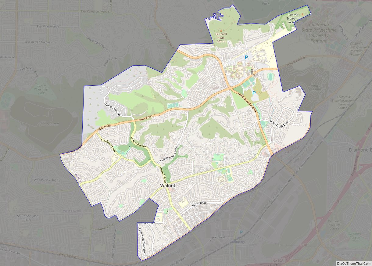
Map of Waterford city

Map of Waterford city, California

Waterford is the eighth largest city in Stanislaus County, California, United States. The population was 9,120 at the 2020 census, up from 8,456 as of the 2010 census. Waterford is part of the Modesto Metropolitan Statistical Area. Waterford city overview: Name: Waterford city LSAD Code: 25 LSAD Description: city (suffix) State: California County: Stanislaus County … Read more

Map of Washington CDP, California

Map of Washington CDP, California

Washington (originally, Indiana Camp) is a census-designated place located in Nevada County, California. Washington is located on the banks of the South Yuba River and has a population of approximately two hundred people. There is a hotel/bar and restaurant, grocery store, a one-room schoolhouse that has educated students continuously for one hundred years, and two … Read more

Map of Wasco city

Map of Wasco city, California

Wasco (formerly, Dewey and Deweyville) is a city in the San Joaquin Valley, in Kern County, California, United States. Wasco is located 24 miles (39 km) northwest of Bakersfield, at an elevation of 328 feet (100 m). The population was 25,545 at the 2010 census, up from 21,263 at the 2000 census. Wasco is the headquarters of … Read more

Map of Waterloo CDP, California

Map of Waterloo CDP, California

Waterloo is a census-designated place in San Joaquin County, California. Waterloo sits at an elevation of 62 feet (19 m). The 2020 United States census reported Waterloo’s population was 670. Waterloo CDP overview: Name: Waterloo CDP LSAD Code: 57 LSAD Description: CDP (suffix) State: California County: San Joaquin County Elevation: 62 ft (19 m) Total Area: 5.435 sq mi (14.076 km²) … Read more

Map of Waukena CDP

Map of Waukena CDP

Waukena is a census-designated place in Tulare County, California, United States. Waukena is located on California State Route 137 4 miles (6.4 km) northeast of Corcoran. Waukena has a post office with ZIP code 93282. The population was 108 at the 2010 census. Its name is possible derived from an archaic English interpretation of the Spanish … Read more

Map of Watsonville city

Map of Watsonville city

Watsonville is a city in Santa Cruz County, California, in the Monterey Bay Area of the Central Coast of California. The population was 52,590 at the 2020 census. Predominantly Latino, working-class, and Democratic, Watsonville is a self-designated sanctuary city. Watsonville city overview: Name: Watsonville city LSAD Code: 25 LSAD Description: city (suffix) State: California County: … Read more

Map of Weed city

Map of Weed city, California

Weed is a city in Siskiyou County, California, United States. As of the 2020 Census, the city had a total population of 2,862, down from 2,967 in 2010. There are several unincorporated communities adjacent to, or just outside, Weed proper, including Edgewood, Carrick, and Lake Shastina. These communities generally have mailing addresses that use Weed … Read more

Map of Weaverville CDP

Map of Weaverville CDP, California

Weaverville is a census-designated place and the county seat of Trinity County, California, United States. Its population is 3,667 as of the 2020 census, up from 3,600 from the 2010 census. Weaverville CDP overview: Name: Weaverville CDP LSAD Code: 57 LSAD Description: CDP (suffix) State: California County: Trinity County Elevation: 2,051 ft (625 m) Total Area: 10.424 sq mi … Read more

Map of Wawona CDP

Map of Wawona CDP

Wawona (formerly Big Tree Station, Clark’s Station, Clarks Station, Wah-wo-nah, and Clark’s Ranch) is a census-designated place in Mariposa County, California, United States. The population was 111 at the 2020 census. It is located entirely within Yosemite National Park, as it preceded the founding of the park as a national recreation area. The number of … Read more

Map of Weott CDP

Map of Weott CDP

Weott is a census-designated place in Humboldt County, California. It is located 233 miles (375 km) north of San Francisco and 25 miles (40 km) due east of the Pacific Ocean. Lower Weott is situated at an elevation of 330 feet (100 m) along the Avenue of the Giants scenic highway and in the flood plain of the … Read more

Map of Weldon CDP, California

Map of Weldon CDP, California

Weldon is a census-designated place (CDP) in Kern County, California, United States. It sits at the southeast tip of Lake Isabella. Weldon is located 9 miles (14 km) east-southeast of Wofford Heights, at an elevation of 2,654 feet (809 m). The population was 2,642 at the 2010 census, up from 2,387 at the 2000 census. Weldon CDP … Read more

Map of Weedpatch CDP

Map of Weedpatch CDP

Weedpatch (formerly Weed Patch and Alexander’s Corner) is an unincorporated community and census-designated place (CDP) in Kern County, California, United States. Weedpatch is 10 miles (16 km) south-southeast of Bakersfield. It is considered to be one of the poorest areas in Kern County. As of the 2010 census it had a population of 2,658. Weedpatch CDP … Read more