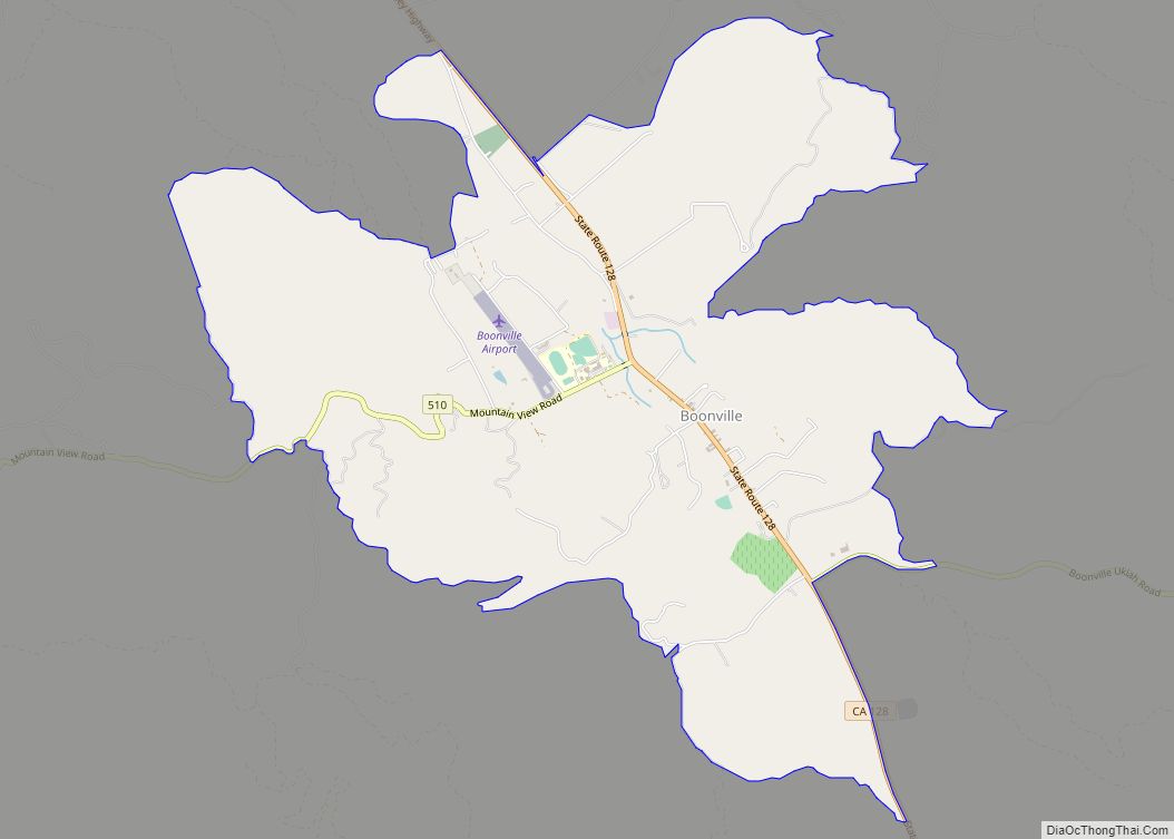
Map of Bostonia CDP

Map of Bostonia CDP

Bostonia is a neighborhood in San Diego County, California, comprising part of the northeastern portion of the city of El Cajon, as well as adjacent unincorporated areas of San Diego County. The portion of Bostonia that lies outside the El Cajon city limits is classified as a census-designated place (CDP) for statistical purposes by the … Read more

Map of Borrego Springs CDP

Map of Borrego Springs CDP

Borrego Springs (borrego is Spanish for “sheep”) is a census-designated place (CDP) in San Diego County, California. The population was 3,429 at the 2010 census, up from 2,535 at the 2000 census, made up of both seasonal and year-round residents. Borrego Springs is surrounded by Anza-Borrego State Park, California’s largest state park. The village of … Read more

Map of Boronda CDP

Map of Boronda CDP

Boronda is an unincorporated community and census-designated place (CDP) in Monterey County, California, United States. The population was 1,760 at the 2020 census. Boronda is located directly west of Salinas and is named after José Eusebio Boronda, a Californio ranchero, and located on the lands of his Rancho Rincón del Sanjón. Boronda CDP overview: Name: … Read more

Map of Bowles CDP

Map of Bowles CDP

Bowles is a census-designated place (CDP) in Fresno County, California, United States. The population was 166 at the 2010 census, down from 182 at the 2000 census. Bowles is located 11 miles (18 km) south of downtown Fresno, at an elevation of 279 feet (85 m). Bowles CDP overview: Name: Bowles CDP LSAD Code: 57 LSAD … Read more

Map of Boulevard CDP

Map of Boulevard CDP

Boulevard is a census-designated place (CDP) in the Mountain Empire area of southeastern San Diego County, California. At the , it had a population of 359 at the 2020 United States census, up from 315 at the 2010 census. The area is rural high desert along the Mexican border near the eastern extent of San … Read more

Map of Boulder Creek CDP

Map of Boulder Creek CDP

Boulder Creek (/ˈbəʊl.dər ˈkriːk/) is a small rural mountain community in the coastal Santa Cruz Mountains. It is a census-designated place (CDP) in Santa Cruz County, California, with a population of 5,429 as of the 2020 census. Throughout its history, Boulder Creek has been home to a logging town and a resort community, as well … Read more

Map of Bradley CDP, California

Map of Bradley CDP, California

Bradley is an unincorporated community and census-designated place (CDP) in Monterey County, California, on the Salinas River 14 miles (23 km) south-southeast of San Ardo and 20 miles (32 km) north of Paso Robles. Bradley sits at an elevation of 548 feet (167 m). The population was 69 at the 2020 census, down from 93 at the 2010 … Read more

Map of Bradbury city

Map of Bradbury city

Bradbury is a city in the San Gabriel Valley region of Los Angeles County, California, United States. It is located in the foothills of the San Gabriel Mountains below Angeles National Forest. Bradbury is bordered by the city of Monrovia to the west and south, and Duarte to the south and east. The population was … Read more

Map of Boyes Hot Springs CDP

Map of Boyes Hot Springs CDP

Boyes Hot Springs (also called Boyes Springs or The Springs)is a census-designated place (CDP) in Sonoma Valley, Sonoma County, California, United States. The population was 6,656 people at the 2010 census. Resorts in Boyes Hot Springs, El Verano, Fetters Hot Springs, and Agua Caliente were popular health retreats for tourists from San Francisco and points … Read more

Map of Brentwood city

Map of Brentwood city, California

Brentwood is a city in Contra Costa County, California, United States. It is located in the East Bay region of the San Francisco Bay Area. The population is 66,854 as of 2022, an increase of 287% from 23,302 at the 2000 census. Brentwood began as a community in the late 19th century. The community is … Read more

Map of Brea city

Map of Brea city

Brea (/ˈbreɪə/; Spanish for “tar”) is a city in northern Orange County, California. The population as of the 2010 census was 39,282. It is 33 miles (53 km) southeast of Los Angeles. Brea is part of the Los Angeles metropolitan area. The city began as a center of crude oil production, was later propelled by citrus … Read more

Map of Brawley city

Map of Brawley city

Brawley (formerly Braly) is a city in Imperial County, California, United States within the Imperial Valley. The population was 24,953 at the 2010 census, up from 22,052 in 2000. Year-round agriculture is an important economic activity in Brawley. The town has a significant cattle and feed industry, and hosts the annual Cattle Call Rodeo. Summer … Read more