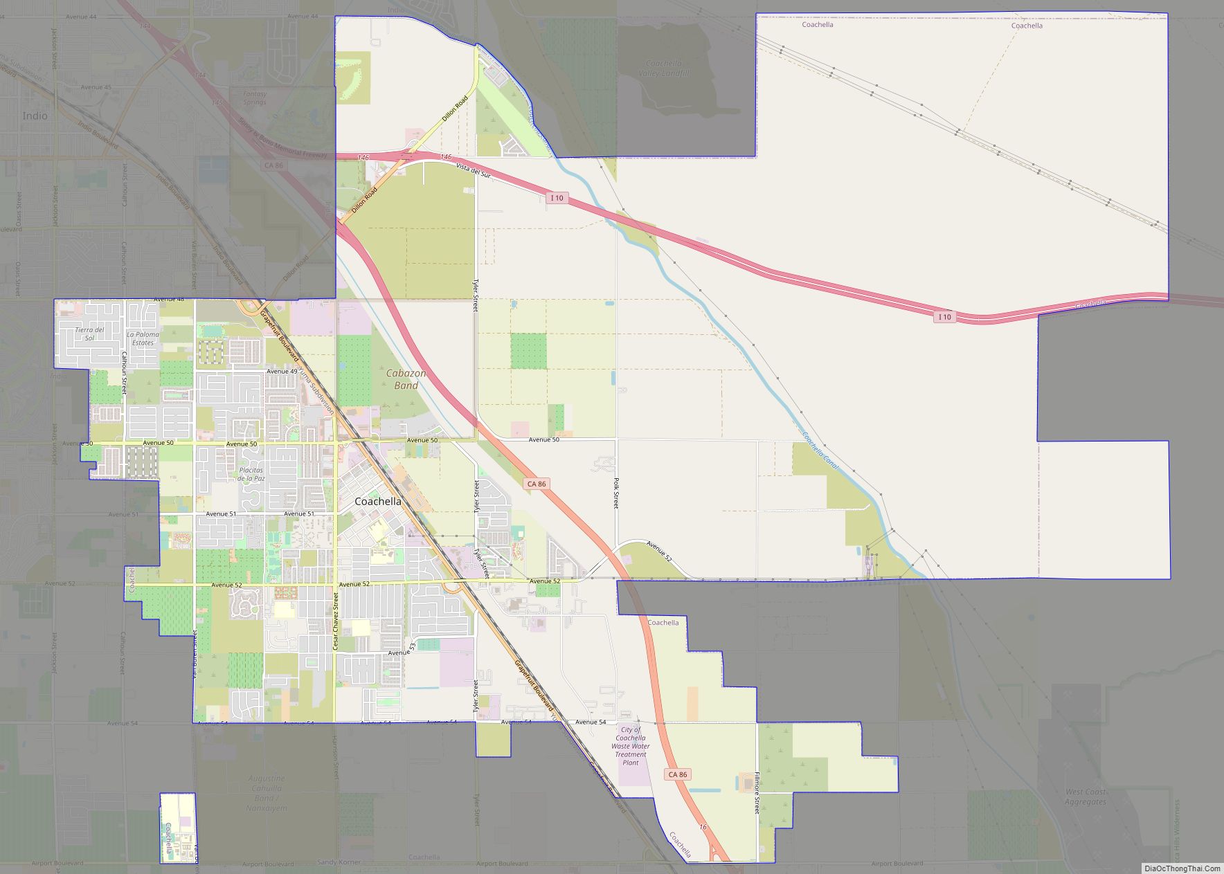
Map of Cohasset CDP

Map of Cohasset CDP, California

Cohasset (formerly, Keefers Ridge and North Point) is a census-designated place in Butte County, California, United States, approximately 17.7 miles (28.5 km) NNE of Chico, California. Its main street is named Cohasset Road, which comes from the Algonquian Indian language and means “long rocky place”. The population was 847 at the 2010 census. The town is … Read more

Map of Coffee Creek CDP

Map of Coffee Creek CDP

Coffee Creek is a census-designated place located within Trinity County in the U.S. state of California. It is located just north of where Coffee Creek flows into the Trinity River along Highway 3 and is the most northern community in Trinity County. It contains the Coffee Creek elementary school. Coffee Creek Road originates at Highway … Read more

Map of Cobb CDP

Map of Cobb CDP, California

Cobb is a census designated place (CDP) in Lake County, California, United States. Cobb is located 1 mile (1.6 km) northwest of Whispering Pines, at an elevation of 2,631 feet (802 m). The population was 1,778 at the 2010 census, up from 1,638 at the 2000 census. Cobb CDP overview: Name: Cobb CDP LSAD Code: 57 LSAD … Read more

Map of Colfax city

Map of Colfax city, California

Colfax (formerly Alden Grove, Alder Grove, Illinoistown, and Upper Corral) is a city in Placer County, California, at the crossroads of Interstate 80 and State Route 174. The population was 1,963 at the 2010 census. The town is named in honor of U.S. Vice President Schuyler Colfax (1869–73), a bronze statue of whom stands at … Read more

Map of Coleville CDP

Map of Coleville CDP

Coleville is an unincorporated community and census-designated place (CDP) in Mono County, California, United States. It is located at an elevation of 5,141 feet (1,567 m) in the Antelope Valley on the West Walker River. The population was 419 at the 2020 census, down from 495 at the 2010 census. The ZIP Code is 96107, and … Read more

Map of Cold Springs CDP

Map of Cold Springs CDP, California

Cold Springs is a census-designated place (CDP) in Tuolumne County, California. Cold Springs sits at an elevation of 5,315 feet (1,620 m). The 2010 United States census reported Cold Springs’s population was 181. Cold Springs CDP overview: Name: Cold Springs CDP LSAD Code: 57 LSAD Description: CDP (suffix) State: California County: Tuolumne County Elevation: 5,315 ft (1,620 m) … Read more

Map of Collierville CDP

Map of Collierville CDP, California

Collierville is a census-designated place in San Joaquin County, California. Collierville sits at an elevation of 62 feet (19 m). The 2020 United States census reported Collierville’s population was 2,698. Collierville CDP overview: Name: Collierville CDP LSAD Code: 57 LSAD Description: CDP (suffix) State: California County: San Joaquin County Elevation: 62 ft (19 m) Total Area: 6.60 sq mi (17.11 km²) … Read more

Map of College City CDP

Map of College City CDP

College City is a census-designated place in Colusa County, California. It lies at an elevation of 72 feet (22 m) above sea level. Its ZIP code is 95912, and its area code is 530. Its population was 290 at the 2010 census. College City CDP overview: Name: College City CDP LSAD Code: 57 LSAD Description: CDP … Read more

Map of Colma town

Map of Colma town

Colma (Ohlone for “Springs”) is a small incorporated town in San Mateo County, California, on the San Francisco Peninsula in the San Francisco Bay Area. The population was 1,507 at the 2020 census. The town was founded as a necropolis in 1924. With most of Colma’s land dedicated to cemeteries, the population of the dead—not … Read more

Map of Columbia CDP, California

Map of Columbia CDP, California

Columbia is a census-designated place (CDP) located in the Sierra Nevada foothills in Tuolumne County, California, United States. It was founded as a boomtown in 1850 when gold was found during the California Gold Rush, and was known as the “Gem of the Southern Mines.” The town’s historic central district is within the Columbia State … Read more

Map of Colton city

Map of Colton city, California

Colton is a city in San Bernardino County, California, United States. Nicknamed “Hub City”, Colton is located in the Inland Empire region of the state and is a suburb of San Bernardino, approximately 4 miles (6.4 km) south of the city’s downtown. The population of Colton is 52,154 according to the 2010 census, up from 47,662 … Read more

Map of Coloma CDP

Map of Coloma CDP, California

Coloma (Nisenan: Cullumah, meaning “beautiful”) is a census-designated place in El Dorado County, California, US. It is approximately 36 miles (58 km) northeast of Sacramento, California. Coloma is most noted for being the site where James W. Marshall found gold in the Sierra Nevada foothills, at Sutter’s Mill on January 24, 1848, leading to the California … Read more