Colma (Ohlone for “Springs”) is a small incorporated town in San Mateo County, California, on the San Francisco Peninsula in the San Francisco Bay Area. The population was 1,507 at the 2020 census. The town was founded as a necropolis in 1924.
With most of Colma’s land dedicated to cemeteries, the population of the dead—not specifically known but speculated to be around 1.5 million—outnumbers that of the living by a ratio of nearly a thousand to one. This has led to Colma being called “the City of the Silent” and has given rise to a humorous motto, formerly featured on the city’s website: “It’s great to be alive in Colma”.
| Name: | Colma town |
|---|---|
| LSAD Code: | 43 |
| LSAD Description: | town (suffix) |
| State: | California |
| County: | San Mateo County |
| Elevation: | 121 ft (37 m) |
| Total Area: | 1.89 sq mi (4.90 km²) |
| Land Area: | 1.89 sq mi (4.90 km²) |
| Water Area: | 0.00 sq mi (0.00 km²) 0% |
| Total Population: | 1,507 |
| Population Density: | 796.93/sq mi (307.78/km²) |
| ZIP code: | 94014 |
| Area code: | 650 |
| FIPS code: | 0614736 |
| GNISfeature ID: | 1658303 |
| Website: | www.colma.ca.gov |
Online Interactive Map
Click on ![]() to view map in "full screen" mode.
to view map in "full screen" mode.
Colma location map. Where is Colma town?


History
The community of Colma was formed in the 19th century as a collection of homes and small businesses along El Camino Real and the adjacent San Francisco and San Jose Railroad line. Several churches, including Holy Angels Catholic Church, were founded in these early years. The community founded its own fire district, which serves the unincorporated area of Colma north of the town limits, as well as the area that became a town in 1924.
Heinrich (Henry) von Kempf moved his wholesale nursery here in the early part of the 20th century, from the land where the Palace of Fine Arts currently sits. The business was growing, and thus required more space for von Kempf’s plants and trees. Von Kempf then began petitioning to turn the Colma community into an agricultural township. He succeeded and became the town of Colma’s first treasurer.
In the early 20th century, Colma was the site of many major boxing events. Middleweight world champion Stanley Ketchel fought six bouts at the Mission Street Arena in Colma, including two world middleweight title bouts against Billy Papke and a world heavyweight title bout against Jack Johnson.
San Francisco cemetery relocations
Colma became the site for numerous cemeteries after San Francisco outlawed new interments within its city limits in 1900, then evicted all existing cemeteries in 1912. In the 1910s, many of the roads to Colma were not maintained. Bodies were transported by street cars in San Francisco down Valencia Street in the Mission District; which resulted in many mortuaries and funeral homes in this location for quick access to Colma. Approximately 150,000 bodies were moved between 1920 and 1941, at a cost of $10 per grave and marker. Many of the remains in Colma came from the Lone Mountain Cemetery complex. Those for whom no one paid the fee were reburied in mass graves, and the markers were recycled in various San Francisco public works. Some examples include drain gutters at Buena Vista Park and bolstering breakwater near the St. Francis Yacht Club. They can be seen at low tide on Ocean Beach. The completion of the relocation was delayed until after World War II. The main rail line between San Francisco and San Jose running through Colma had been bypassed in 1907 for a route closer to the San Francisco Bay shoreline, and the former main line was repurposed as a branch line to move coffins to Colma. Decades later, the right-of-way for the rail line through Colma was purchased by BART for use in the San Francisco International Airport extension project.
The Town of Lawndale was incorporated in 1924, primarily at the behest of the cemetery owners with the cooperation of the handful of residents who lived closest to the cemeteries. The residential and business areas immediately to the north continued to be known as Colma. As another California city named Lawndale already existed, in Los Angeles County, the post office retained the Colma designation, and the town changed its name back to Colma in 1941.
Notable interments
Many, if not most, of the well-known people who died in San Francisco since the first cemeteries opened there have been buried or reburied in Colma, with an additional large number of such burials in Oakland’s Mountain View Cemetery. Some notable people interred in Colma include:
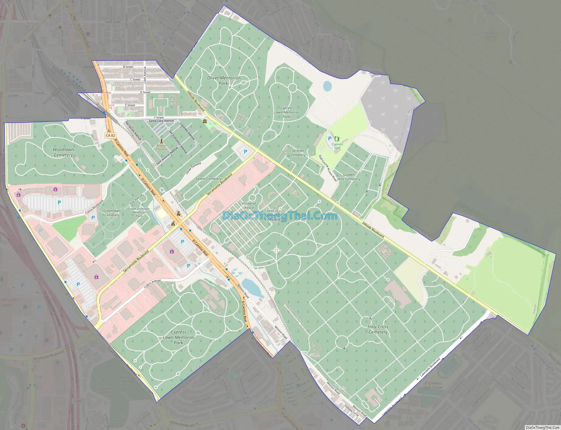
- Cypress Lawn Memorial Park
- William Henry Crocker, business magnate
- Charles de Young, San Francisco Chronicle founder
- Phineas Gage, famous 19th-century medical curiosity
- Edward Gilbert, California politician and co-founder of the Alta California
- William Randolph Hearst, newspaper tycoon
- Ed Lee, first Asian American Mayor of San Francisco
- Willie McCovey, Major League Baseball Hall of Famer
- John McLaren, horticulturist
- Turk Murphy, jazz musician and bandleader
- Hills of Eternity Memorial Park and Home of Peace Cemetery (side-by-side Jewish cemeteries, serving different congregations)
- Wyatt Earp is buried next to his wife, Josephine Marcus Earp
- Julie Rosewald, America’s first female cantor
- Levi Strauss, denim trouser pioneer
- Alice B. Toklas is not buried in Colma, though there is a large Toklas cenotaph for her and markers there for some of her relatives
- Holy Cross Cemetery
- Joseph Alioto, San Francisco mayor
- Jimmy Britt, lightweight boxer
- Pat Brown, 32nd governor of California
- Beniamino Bufano, sculptor, noted for peace monuments and other statues
- Frank “the Crow” Crosetti, New York Yankees shortstop
- Joe DiMaggio, Yankees center fielder
- Abigail Folger, coffee heiress and Manson murder victim
- A.P. Giannini, Bank of America founder
- Vince Guaraldi, jazz musician
- Capt. Michael A. Healy, United States Revenue Cutter Service Officer, and first man of African-American descent to command a ship of the United States government.
- James D. Phelan, senator
- Woodlawn Memorial Park Cemetery
- Thomas Henry Blythe, developer of Palo Verde Valley
- Henry Miller, California cattle rancher
- Emperor Norton, a late-1800s San Francisco celebrity known as “Emperor of these United States and Protector of Mexico”
- José Sarria, LGBT political activist who styled himself “The Widow Norton” in reference to Norton
- Eternal Home Cemetery (Jewish Cemetery)
- Bill Graham, music promoter
- Greek Orthodox Memorial Park
- George Christopher, San Francisco mayor
- Serbian Cemetery
- Boris Pash, Russian-American military intelligence officer
- Gregory Udicki, Serbian Orthodox Bishop of the Diocese of Western America
- Greenlawn Memorial Cemetery
- James Rolph, San Francisco mayor and 27th governor of California
- Japanese Cemetery
- George Shima, businessperson
Colma Road Map
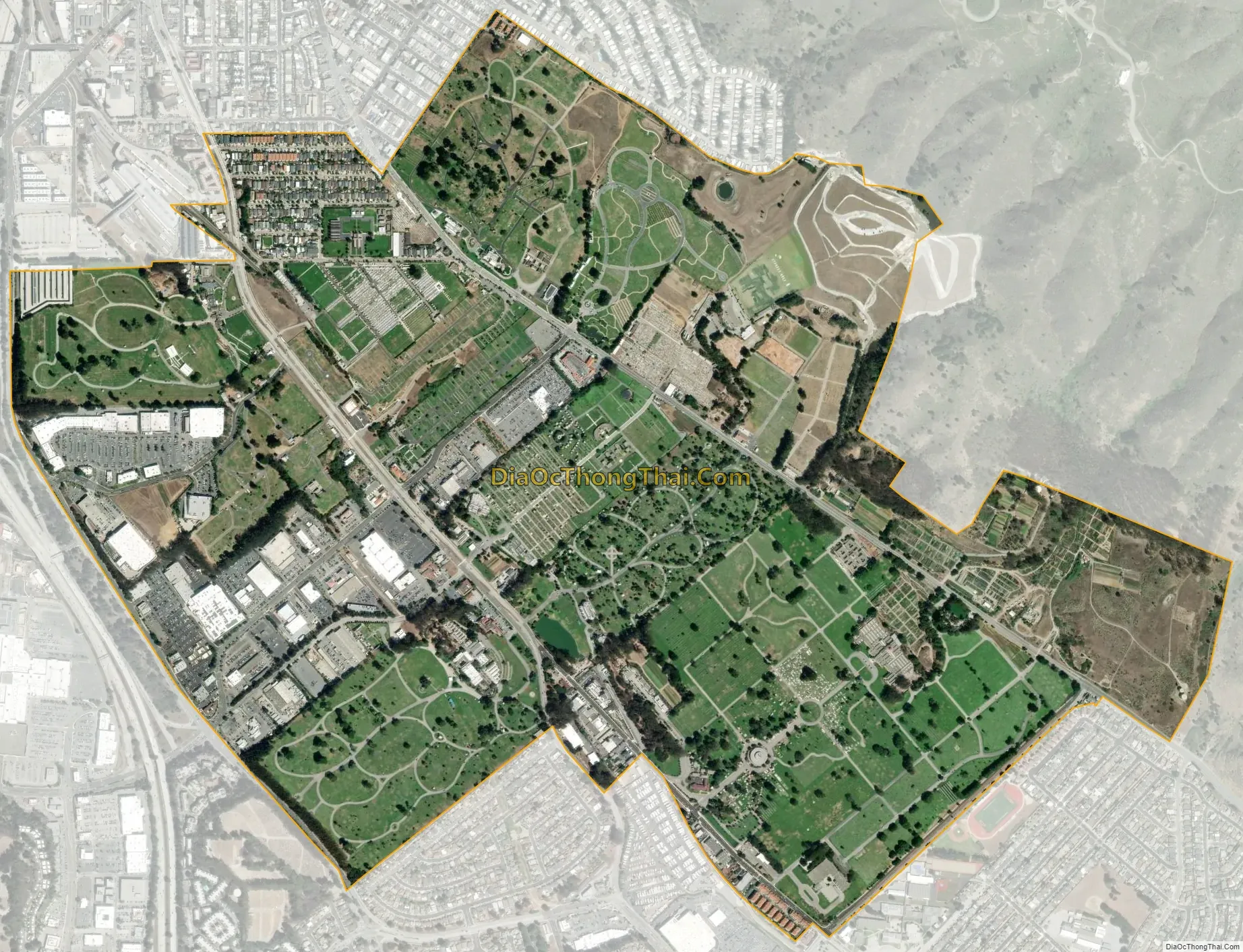
Colma city Satellite Map
Geography
According to the United States Census Bureau, the town has a total area of 1.9 sq mi (4.9 km), all land. The town’s 17 cemeteries comprise approximately 73% of the town’s land area.
Colma is situated on the San Francisco Peninsula at the highest point of the Merced Valley, a gap between San Bruno Mountain and the northernmost foothills of the Santa Cruz Mountain Range. The foothills and eastern flanks of the range are composed largely of poorly consolidated Pliocene-Quaternary freshwater and shallow marine sediments that include the Colma and Merced Formations, recent slope wash, ravine fill, colluvium, and alluvium. These surficial deposits unconformably overlay the much older Jurassic to Cretaceous-aged Franciscan Assemblage. An old landfill about 135 feet deep existed at the site developed by the 260,000 sq ft (24,000 m) mixed-use Metro Center.
Colma Creek flows through the city as it makes its way from San Bruno Mountain to San Francisco Bay.
See also
Map of California State and its subdivision:- Alameda
- Alpine
- Amador
- Butte
- Calaveras
- Colusa
- Contra Costa
- Del Norte
- El Dorado
- Fresno
- Glenn
- Humboldt
- Imperial
- Inyo
- Kern
- Kings
- Lake
- Lassen
- Los Angeles
- Madera
- Marin
- Mariposa
- Mendocino
- Merced
- Modoc
- Mono
- Monterey
- Napa
- Nevada
- Orange
- Placer
- Plumas
- Riverside
- Sacramento
- San Benito
- San Bernardino
- San Diego
- San Francisco
- San Joaquin
- San Luis Obispo
- San Mateo
- Santa Barbara
- Santa Clara
- Santa Cruz
- Shasta
- Sierra
- Siskiyou
- Solano
- Sonoma
- Stanislaus
- Sutter
- Tehama
- Trinity
- Tulare
- Tuolumne
- Ventura
- Yolo
- Yuba
- Alabama
- Alaska
- Arizona
- Arkansas
- California
- Colorado
- Connecticut
- Delaware
- District of Columbia
- Florida
- Georgia
- Hawaii
- Idaho
- Illinois
- Indiana
- Iowa
- Kansas
- Kentucky
- Louisiana
- Maine
- Maryland
- Massachusetts
- Michigan
- Minnesota
- Mississippi
- Missouri
- Montana
- Nebraska
- Nevada
- New Hampshire
- New Jersey
- New Mexico
- New York
- North Carolina
- North Dakota
- Ohio
- Oklahoma
- Oregon
- Pennsylvania
- Rhode Island
- South Carolina
- South Dakota
- Tennessee
- Texas
- Utah
- Vermont
- Virginia
- Washington
- West Virginia
- Wisconsin
- Wyoming


